
Unincorporated communities lacking elected municipal officers and boundaries with legal status, but are not classified as Census-designated places (CDPs). [1]
Unincorporated communities lacking elected municipal officers and boundaries with legal status, but are not classified as Census-designated places (CDPs). [1]

Autauga County is a county located in the central portion of the U.S. state of Alabama. As of the 2020 census the population was 58,805. Its county seat is Prattville.

Baldwin County is a county located in the southwestern part of the U.S. state of Alabama, on the Gulf coast. It is one of only two counties in Alabama that border the Gulf of Mexico, along with Mobile County. As of the 2020 census, the population was 231,767. The county seat is Bay Minette. The county is named after the founder of the University of Georgia, Senator Abraham Baldwin.

Edgewater is a census-designated place in Jefferson County, Alabama, United States. It is northeast from the Birmingham suburb of Pleasant Grove. Its population was 883 at the 2010 census. This area was damaged by tornadoes on April 15, 1956 and April 8, 1998. The 1998 tornado was rated F5 on the Fujita scale.
The following is a set–index article, providing a list of lists, for the cities, towns and villages within the jurisdictional United States. It is divided, alphabetically, according to the state, territory, or district name in which they are located.

Carlton is an census-designated place in Clarke County, Alabama, United States. As of the 2020 census, its population was 46. It was formerly known as Hal's Lake. The Isaac Nettles Gravestones are located in Carlton in the Mount Nebo Baptist Church Cemetery. They are listed on the National Register of Historic Places. There was one convenience store in Carlton until 2009.
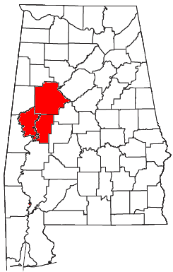
The Tuscaloosa metropolitan area, as defined by the United States Census Bureau, is an area consisting of three counties in west central Alabama, anchored by the city of Tuscaloosa. As of the 2020 census, the MSA had a population of 268,674.
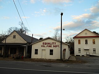
Equality is a census-designated place in Coosa County, Alabama, United States. It was first named as a CDP in the 2020 Census which listed a population of 150. The Equality post office serves the ZIP Code of 36026, and its delivery area includes rural land to the south in Elmore County.

Chunchula is an unincorporated community and census-designated place (CDP) in Mobile County, Alabama, United States. As of the 2020 census, its population was 195. It has a post office with the 36521 ZIP code. The community has one site listed on the Alabama Register of Landmarks and Heritage, the Chunchula School.

Joppa is a census-designated place (CDP) and unincorporated community in Cullman and Marshall counties, Alabama, United States. As of the 2020 census, its population was 556.

Vandiver is a census-designated place (CDP) and unincorporated community in Shelby County, Alabama, United States. Its population was 1168 as of the 2010 census. One structure in Vandiver, the Falkner School, is listed on the Alabama Register of Landmarks and Heritage.

Shelby is a census-designated place and unincorporated community in Shelby County, Alabama, United States. Its population was 1,044 as of the 2010 census. The area is near Lay Lake and Waxahatchee Creek. Shelby Iron Park is located at the heart of the area. Two sites in Shelby, The Brick House and the Old Shelby Hotel, are listed on the Alabama Register of Landmarks and Heritage.

Sterrett is a census-designated place and unincorporated community in Shelby County, Alabama, United States. Its population was 712 as of the 2010 census. Sterrett was named in honor of a prominent local family, which included Alphonso A. Sterrett, who served in the Alabama Legislature. At one point in its history, Sterrett was a center of pottery production in central Alabama. Also known as Jugtown, Sterrett was once home to at least ten potters. The pottery produced here was classified as being part of the East Alabama style of pottery, which used high quality clay and a two-toned glaze decoration. William Hilliard Falkner purchased the Sterrett Pottery Works in 1874 and operated it until 1903. His father, Joel Falkner, was also a potter in Sterrett.
Remlap is a census-designated place in Blount County, Alabama, United States, located along Alabama State Route 75, 11.7 miles (18.8 km) southwest of Oneonta. Remlap has a post office with ZIP code 35133.
Pea Ridge is a census-designated place in Shelby County, Alabama, United States. The community is named for Pea Ridge, the broadest ridge in the Cahaba Coal Field. This ridge divides the waters of the Cahaba River and Little Cahaba River. Pea Ridge has maintained a volunteer fire department since 1972.
Nixburg is a census-designated place in Coosa County, Alabama, United States.
Eagle Point is a census-designated place in Shelby County, Alabama, United States. It was first listed as a CDP prior to the 2020 census and is part of the Birmingham Metropolitan Area. The area was struck by a long-tracked low-end EF3 tornado on March 25, 2021, damaging or destroying several homes and downing trees. Five people were injured by the tornado.