
Metropolitan Manila, formally the National Capital Region and commonly called Metro Manila, is the capital region and largest metropolitan area of the Philippines. The region is located on the eastern shore of Manila Bay, between the Central Luzon and Calabarzon regions. It consists of 16 highly urbanized cities: the City of Manila, Caloocan, Las Piñas, Makati, Malabon, Mandaluyong, Marikina, Muntinlupa, Navotas, Parañaque, Pasay, Pasig, Quezon City, San Juan, Taguig, and Valenzuela, and one municipality: Pateros. The region encompasses an area of 619.57 square kilometers (239.22 sq mi) and a population of 13,484,462 as of 2020. It is the second most populous and the most densely populated region in the Philippines. It is also the 9th most populous metropolitan area in Asia and the 6th most populous urban area in the world.

Makati, officially the City of Makati, is a 1st class highly urbanized city in the National Capital Region of the Philippines.

The Pasig River is a water body in the Philippines that connects Laguna de Bay to Manila Bay. Stretching for 25.2 kilometers (15.7 mi), it bisects the Philippine capital of Manila and its surrounding urban area into northern and southern halves. Its major tributaries are the Marikina River and San Juan River. The total drainage basin of the Pasig River, including the basin of Laguna de Bay, covers 4,678 square kilometers (1,806 sq mi).

Quezon City, also known as the City of Quezon and Q.C., is the most populous city in the Philippines. According to the 2020 census, it has a population of 2,960,048 people. It was founded on October 12, 1939, and was named after Manuel L. Quezon, the second president of the Philippines.

Pasay, officially the City of Pasay, is a 1st class highly urbanized city in the National Capital Region of the Philippines. According to the 2020 census, it has a population of 440,656 people.

Mandaluyong, officially the City of Mandaluyong, is a first class highly urbanized city in the National Capital Region of the Philippines. According to the 2020 census, it has a population of 425,758 people.

Pasig, officially the City of Pasig, is a highly urbanized city in the National Capital Region of the Philippines. According to the 2020 census, it has a population of 803,159 people.
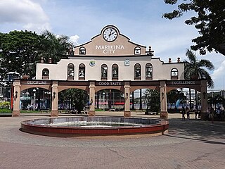
Marikina, officially the City of Marikina, is a 1st class highly urbanized city in the National Capital Region of the Philippines. According to the 2020 census, it has a population of 456,159 people.

Ortigas Center is a central business district located within the joint boundaries of Pasig, Mandaluyong and Quezon City, within the Metro Manila region in the Philippines. With an area of more than 100 hectares, it is Metro Manila's second most important business district after the (Makati CBD). It is governed by Ortigas Center Association, Inc.

Taguig, officially the City of Taguig, is a 1st class highly urbanized city in Metro Manila, Philippines. According to the 2020 census, it has a population of 886,722 people. Located in the northwestern shores of Laguna de Bay, the city is known for Bonifacio Global City, one of the leading financial centers of the Philippines. Originally a fishing village during the Spanish and American colonial periods, it experienced rapid growth when former military reservations were converted by the Bases Conversion and Development Authority (BCDA) into mixed-use planned communities. Taguig became a highly urbanized city with the passage of Republic Act No. 8487 in 2004.

Caloocan, officially the City of Caloocan, is a 1st class highly urbanized city in Metro Manila, Philippines. According to the 2020 census, it has a population of 1,661,584 people making it the fourth-most populous city in the Philippines.

San Juan, officially the City of San Juan, is a 1st class highly urbanized city in the National Capital Region of the Philippines. According to the 2020 census, it has a population of 126,347 people. It is geographically located at Metro Manila's approximate center and is also the country's smallest city in terms of land area.

Taytay, officially the Municipality of Taytay, is a 1st class urban municipality in the province of Rizal, Philippines. It is also known as the Garments Capital of the Philippines. Most occupation of the residents are related to supplying different types of garments related things like blouses, pants, dresses and the garment itself at a very low cost.
Namayan, also called Sapa, Maysapan, and sometimes Lamayan, was an independent indigenous polity on the banks of the Pasig River in the Philippines. It is believed to have achieved its peak in 1175, and to have gone into decline sometime in the 13th century, although it continued to be inhabited until the arrival of European colonizers in the 1570s.

Greenhills is an administrative division in eastern Metro Manila, the Philippines. It is an urban barangay in San Juan and is the largest barangay in the city, covering a total area of 2.09 square kilometers (209 ha) that spans over a third of San Juan's total land area.

The San Juan River is one of the main river systems in Metro Manila, Philippines, and is a major tributary of the Pasig River. It begins near La Mesa Dam as the San Francisco del Monte River, which officially takes the name San Juan River when it meets with Mariblo Creek in Quezon City. As the San Juan River, it passes through Quezon City, San Juan, the Manila district of Santa Mesa and Santa Ana, and Mandaluyong.

Ortigas Avenue is a 12.1 km (7.5 mi) highway running from eastern Metro Manila to western Rizal in the Philippines. It is one of the busiest highways in Metro Manila, serving as the main thoroughfare of the metro's east–west corridor, catering mainly to the traffic to and from Rizal.
Metro Manila, the capital region of the Philippines, is a large metropolitan area that has several levels of subdivisions. Administratively, the region is divided into seventeen primary local government units with their own separate elected mayors and councils who are coordinated by the Metropolitan Manila Development Authority, a national government agency headed by a chairperson directly appointed by the Philippine president. The cities and municipality that form the region's local government units are further divided into several barangays or villages which are headed by an elected barangay captain and barangay council.
Barangay BF Homes Caloocan or Barangay 169 is a barangay of Caloocan, Metro Manila, Philippines. The barangay is known for having jurisdiction of the larger portions of the Banco Filipino-developed real estate projects in Northern Manila, and is considered the most affluent barangay in Caloocan.

Plainview is an administrative division in eastern Metro Manila, the Philippines. It is an urban barangay in Mandaluyong and is home to the city's seat of government and government center. It is the fourth largest barangay in the city.


