Punturin, Valenzuela

Last updated
Punturin
504Punturin Road, Valenzuela City 09.jpg
Faustino Street
Punturin, Valenzuela
Ph fil congress valenzuela 1d.png
Red pog.svg
Punturin
Location of Punturin in the 1st legislative district of Valenzuela
Coordinates: 14°44′17″N120°59′52″E / 14.73806°N 120.99778°E / 14.73806; 120.99778
Country Philippines
Region National Capital Region
City Valenzuela
Congressional districtsPart of the 1st district of Valenzuela
Government
   Barangay chairmanAngelito Ramirez Mariano
Area
  Total1.622 km2 (0.626 sq mi)
Population
 (2015)
  Total20,930
  Density13,000/km2 (33,000/sq mi)

Punturin is one of the 33 barangays that comprises the City of Valenzuela, Philippines. It is a mix of industrial and residential areas like its neighboring barangays of Bignay and Lawang Bato.

Contents

History

In the early times, Punturin was a pure, virgin forest with hills surrounding its vast landscape. Creeks enclosed some of the areas which are directly connected to the Meycauayan River.

The name of the place originated from the word Maraming Puntod which means an abundance of hills because of its enveloping terrain.

With the onset of civilization, the people decide to clear the wilderness for more agricultural lands to till. Wood materials gathered from the forest were used in setting up their homes. Fishing was also a primary means of livelihood because of the abundant aquatic resources from the river.

Punturin was used to be a part of Barrio Lawang Bato but as the number of residents increased, it was decided by the old inhabitants to separate the northern part of the area. The barangay was officially established on April 4, 1945 under Mayor Avelino Deato.

Today, Punturin is well known for its industrial areas and its fast-growing population due to different residential areas established within the barangay.

They celebrate fiesta every first day of May, the feast of St. Joseph the Worker. Famous delicacies include kuchinta, bibingka, puto or sweet rice desserts. An estimated 20,930 residents live in Punturin in this 162.20 square hectare barangay. [1]

Education

Elementary and high school education is accessible for the residents of Punturin. It has two public elementary school and one public high school under the Division of City Schools of Valenzuela. Vicente P. Trinidad National High School, named after the former Brgy. Capt. Vicente Trinidad, is a public high school that serves not only the residents of Punturin, but also its neighboring barangays. Senior high school education is also offered in VPTNHS, but the first senior high school institution in Punturin was in St. Gregory College of Valenzuela. Punturin had also numerous day care centers managed by the City Social Welfare and Development Office.

Public schools

Private schools

Residential areas

Religion

Majority of the residents of the barangay are Roman Catholics. The patron saint of Punturin is St. Joseph the Worker with its feast day celebrated every May 1. Other religions that established churches within Punturin are Iglesia ni Cristo and Members Church of God International among others.

Famous landmarks

Government

Places of worship

Transport terminals

Related Research Articles

<span class="mw-page-title-main">Malabon</span> Highly urbanized city in Metro Manila, Philippines

Malabon, officially the City of Malabon, is a 1st class highly urbanized city in the National Capital Region of the Philippines. According to the 2020 census, it has a population of 380,522 people.

<span class="mw-page-title-main">Valenzuela, Metro Manila</span> Highly urbanized city in Metro Manila, Philippines

Valenzuela, officially the City of Valenzuela, is a 1st class highly urbanized city in the National Capital Region of the Philippines. According to the 2020 census, it has a population of 714,978 people.

<span class="mw-page-title-main">Meycauayan</span> Component city in Bulacan, Philippines

Meycauayan, officially the City of Meycauayan, is a 1st class component city in the province of Bulacan, Philippines. According to the 2020 census, it has a population of 225,673 people. It is one of the oldest towns in the province.

<span class="mw-page-title-main">Bato, Camarines Sur</span> Municipality in Camarines Sur, Philippines

Bato, officially the Municipality of Bato, is a 3rd class municipality in the province of Camarines Sur, Philippines. According to the 2020 census, it has a population of 52,155 people.

<span class="mw-page-title-main">Marilao</span> Municipality in Bulacan, Philippines

Marilao, officially the Municipality of Marilao, is a 1st class urban municipality in the province of Bulacan, Philippines. According to the 2020 census, it has a population of 254,453 people. It is 22 kilometers (14 mi) from Manila and 23 kilometers (14 mi) from the provincial capital Malolos City.

<span class="mw-page-title-main">San Miguel, Bulacan</span> Municipality in Bulacan, Philippines

San Miguel, officially the Municipality of San Miguel, is a 1st class municipality in the province of Bulacan, Philippines. According to the 2020 census, it has a population of 172,073 people.

<span class="mw-page-title-main">Roman Catholic Diocese of Malolos</span> Latin Catholic diocese in the Philippines

The Diocese of Malolos is a Latin Church ecclesiastical jurisdiction or diocese of the Catholic Church in the Philippines, encompassing the whole Province of Bulacan and Valenzuela City in metropolitan Manila and is a suffragan to the metropolitan Archdiocese of Manila. The mother church of the Diocese is the Cathedral-Basilica of the Immaculate Conception located in Malolos City, Bulacan. The Blessed Virgin Mary, under the title of Immaculate Conception is the principal patroness of the diocese.

<span class="mw-page-title-main">Bignay, Valenzuela</span> Barangay in Valenzuela City, Metro Manila, Philippines

Bignay is a barangay in Valenzuela City, Philippines. It was named after a tree called bignay or Antidesma bunius that is plentiful in the area.

<span class="mw-page-title-main">Vicente P. Trinidad National High School</span> Public high school in Valenzuela City, Philippines

Vicente P. Trinidad National High School, formerly Punturin National High School, is a public general high school in Valenzuela City, Philippines. It is located at Sta. Lucia Village Phase V, Punturin, Valenzuela City, Metro Manila, Philippines. It was established in 2003. It is said to be Valenzuela City's School of Performing Arts. It was formerly known as Valenzuela National High School - Punturin Annex and Punturin National High School.

<span class="mw-page-title-main">Division of City Schools–Valenzuela</span>

The Schools Division Office – Valenzuela or simply DCS–Valenzuela is a subdivision of Department of Education mandated to supervise public and private elementary, and secondary(JHS/SHS) education in Valenzuela City, Metro Manila, Philippines. The current head of the Division is Dr. Alejandro G. Ibañez, CESO V, with OIC Assistant Schools Division Superintendent Dr. Rustica R. Lorenzo, CESE

<span class="mw-page-title-main">Dalandanan, Valenzuela</span> Barangay in Valenzuela, Philippines

Dalandanan is one of the highly developed barangays in Valenzuela, Metro Manila, Philippines. It was named after the impressive line of dalandan trees that used to distinguish the area.

<span class="mw-page-title-main">Lawang Bato National High School</span> Public high school in Valenzuela, Philippines

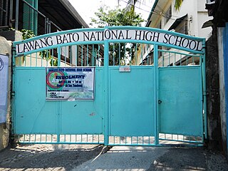
Lawang Bato National High School is a high school in the Philippines. It is located in Centro St., Lawang Bato, Valenzuela City. and known as the first of having a solar powered library in Metro Manila

<span class="mw-page-title-main">Lawang Bato</span> Barangay in Valenzuela City, Metro Manila, Philippines

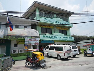
Lawang Bato is a barangay in Valenzuela, Metro Manila, Philippines. The name "Lawang Bato" came from the once rocky land where the barangay once stood.

<span class="mw-page-title-main">Balangkas, Valenzuela</span> Barangay in Valenzuela City, Metro Manila, Philippines

Balangkas is one of the barangays of Valenzuela, Metro Manila, Philippines. Balangkas, translated to English means framework.

<span class="mw-page-title-main">Malanday</span> Barangay in Valenzuela City, Metro Manila, Philippines

Malanday is a settlement and one of the constituent barangays in the city of Valenzuela, Metro Manila, Philippines. It is located in the northern section of the city bordering Meycauayan in the province of Bulacan.

<span class="mw-page-title-main">Bignay National High School</span> School in Valenzuela, Metro Manila, Philippines

Bignay National High School is a public general high school in Valenzuela City, Philippines. It is located at Gitna St., Brgy. Bignay, Valenzuela City.

<span class="mw-page-title-main">Valenzuela's 1st congressional district</span>

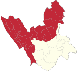
Valenzuela's 1st congressional district is one of the two congressional districts of the Philippines in the city of Valenzuela. It has been represented in the House of Representatives of the Philippines since 2001. The district was created following Valenzuela's conversion into a highly urbanized city through Republic Act No. 8526 on February 14, 1998. It consists of 24 barangays in the northern part of the city, namely Arkong Bato, Balangkas, Bignay, Bisig, Canumay East, Canumay West, Coloong, Dalandanan, Isla, Lawang Bato, Lingunan, Mabolo, Malanday, Malinta, Palasan, Pariancillo Villa, Pasolo, Poblacion, Polo, Punturin, Rincon, Tagalag, Veinte Reales and Wawang Pulo. It is currently vacant for the 19th Congress since the resignation of its most recent representative Rex Gatchalian upon assuming the position of Secretary of Social Welfare and Development in 2023.

<span class="mw-page-title-main">Lingunan</span> Barangay in Valenzuela City, Philippines

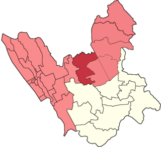
Lingunan is a landlocked 1st congressional district urban barangay in Valenzuela City, Philippines. It borders the barangays Viente Reales to the west, Canumay West to the east, Lawang Bato to the north-east and the city of Meycauayan which its barangays Lawa and Caingin borders it to the north. Based on the 2020 census, it has a population of 24,088.

References

  1. PIO, Administrator, Team. "Punturin". City Government of Valenzuela. Retrieved 2017-09-01.{{cite web}}: CS1 maint: multiple names: authors list (link)

14°44′17″N120°59′52″E / 14.73806°N 120.99778°E / 14.73806; 120.99778