
Las Piñas (Tagalog:[lasˈpiɲɐs], officially the City of Las Piñas, is a 1st class highly urbanized city in the National Capital Region of the Philippines. According to the 2020 census, it has a population of 606,293 people.

Parañaque, officially the City ofParañaque, is a first class highly urbanized city in the National Capital Region of the Philippines. According to the 2020 census, it has a population of 689,992 people.

Muntinlupa, officially the City of Muntinlupa, is a 1st class highly urbanized city in the National Capital Region of the Philippines. According to the 2020 census, it has a population of 543,445 people.

BF Homes Parañaque, officially Barangay BF Homes, is a gated community and administrative division in southern Metro Manila, the Philippines. It is one of the sixteen barangays that make up Parañaque and is the city's largest barangay and southernmost village. As a subdivision, the local term for gated community, its territory includes portions of neighboring cities, Las Piñas and Muntinlupa. It was formerly known as Las Piñas-Parañaque BF Homes and was developed by Banco Filipino owner Tomas Aguirre in 1968. The development was part of the BF Homes project, alongside its sister branches in Quezon City, Caloocan, and Naga, and became fully operational by early 1970. Philippine media refer to it as "the biggest subdivision in Asia". The larger portion of the development in Parañaque was carved out of the village of San Dionisio to form its own barangay in 1978.

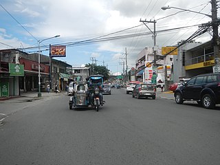
Dr. Arcadio Santos Avenue or Dr. Santos Avenue, formerly and still referred to as Sucat Road or Parañaque–Sucat Road, is the primary east–west thoroughfare in Parañaque, southern Metro Manila, Philippines. The avenue's western end is in Barangay San Dionisio as the continuation of Ninoy Aquino Avenue. Physically, Ninoy Aquino Avenue connects northbound to NAIA Road in Pasay which, in turn, continues west to Roxas Boulevard back in Parañaque, where it ends. Its eastern end is at the East Service Road, which runs parallel to South Luzon Expressway, in Barangay Sucat, Muntinlupa, where it becomes Meralco Road to service the rest of the route to Sucat railway station.
Doña Soledad Avenue is an east-west route in the southern Metro Manila city of Parañaque, Philippines. It traverses barangays Don Bosco and Moonwalk, both located in northeastern Parañaque. It runs from its intersection with E. Rodriguez Avenue in the eastern edge of Moonwalk. The road continues to the east, entering Better Living Subdivision. It then curves north for a few blocks, then turns east and heads for its terminus at Bicutan Exit of South Luzon Expressway (SLEX) and Skyway. East of SLEX, the avenue continues as East Service Road into San Martin de Porres and Lower Bicutan in Taguig, where it then continues as General Santos Avenue.
Metro Manila, the capital region of the Philippines, is a large metropolitan area that has several levels of subdivisions. Administratively, the region is divided into seventeen primary local government units with their own separate elected mayors and councils who are coordinated by the Metropolitan Manila Development Authority, a national government agency headed by a chairperson directly appointed by the Philippine president. The cities and municipality that form the region's local government units are further divided into several barangays or villages which are headed by an elected barangay captain and barangay council.

The following is an alphabetical list of articles related to the Philippine capital region of Metro Manila.

Tunasan is a barangay in Muntinlupa, Philippines. It is the southernmost barangay of Metro Manila located in the southern section of the city bordering the province of Laguna. The total land area of the barangay is 9.596 km2 (3.705 sq mi), the largest in the city. According to the 2020 census, it has a population of 61,374.
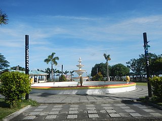
The Sucat People's Park, also known simply as Sucat Park and Sucmun Park, is a lakefront park located on the shore of Laguna de Bay in Muntinlupa, Metro Manila, the Philippines. It is a public community park in a reclaimed portion of the village of Sucat just north of the Sucat Thermal Power Plant on the border between Purok 3 and Purok 4, east of Don Juan Bayview Subdivision. Entry is from M.L. Quezon Street and Meralco Road from the Sucat Interchange of the South Luzon Expressway and Dr. Santos Avenue.

Cupang is a barangay in the Muntinlupa, Metro Manila, Philippines. The total land area of the barangay is 5.370 km2 (2.073 sq mi). It has a population of 57,196 as of the 2020 census. It is located in the northern section of the city.
San Dionisio is an administrative division in southern Metro Manila, Philippines. It is a barangay at the southwestern edge of Parañaque and north of its border with Manuyo, Las Piñas. The barangay is centered on the westernmost section of Dr. Santos Avenue where it veers north and parallels Elpidio Quirino Avenue with De Leon Street and Aldana Avenue forming its boundaries with La Huerta and Manuyo Uno respectively. It extends to the east along the San Dionisio River-Villanueva Creek by barangay Moonwalk to the north and along Balong Creek by Manuyo Dos, Las Piñas to the south towards its border with San Isidro. San Dionisio includes a large swath of the C-5 Road South Extension properties in Parañaque including the Amvel Business Park, Avida Sucat and SM City Sucat sites, the Irasan Complex logistics hub, and as well as the area surrounding the Evacom Plaza. It also covers a significant portion of the reclaimed Freedom and Long Islands in the Las Piñas–Parañaque Critical Habitat and Ecotourism Area.

Santo Niño is an administrative division in southern Metro Manila, the Philippines. It is a barangay in the city of Parañaque immediately surrounding Ninoy Aquino International Airport on its west and south sides. A large portion of the village extends into the property of the airport grounds to include Terminal 1 as well as the western half of Runway 06/24. The village has a total land area of 245.97 hectares of which about 55% is occupied by the airport complex. Its population is concentrated in the areas along the Estero de Tripa de Gallina.

San Martin de Porres is an administrative division in southern Metro Manila, the Philippines. It is an elongated barangay located in the northeast corner of Parañaque adjoining the areas of Bicutan in Taguig and northern Muntinlupa. It is unique in that it is connected to the rest of Parañaque by only two bridges, one of which is a footbridge. Its western border follows the South Luzon Expressway, thus separating it from Merville, Sun Valley, Don Bosco and Marcelo Green. It neighbors Western Bicutan to the north, particularly the redevelopment area of the former Food Terminal Inc. (FTI) known as Arca South. To the east, it adjoins Taguig's barangays of Upper Bicutan, Central Bicutan, North Daang Hari and Tanyag. It neighbors South Daang Hari and Sucat, Muntinlupa to the south.
San Antonio is an administrative division in southern Metro Manila, the Philippines. It is a collection of sixteen gated communities on the east side of Parañaque abutting the city of Muntinlupa, and the informal settlements surrounding them. The barangay is a long strip along the north side of Dr. Santos Avenue stretching from South Luzon Expressway to just west of San Antonio Avenue by the Jaka Plaza commercial center. It is bordered by Marcelo Green to the north, the Muntinlupa barangay of Sucat across the expressway to the east, BF Homes Parañaque across Dr. Santos Avenue to the south, and San Isidro and Moonwalk to the west. It extends to the northwest along San Antonio Avenue and also shares a border with Don Bosco further north and northwest. The barangay is part of the Parañaque's 2nd congressional district.

Don Bosco is an administrative division in Parañaque, Metro Manila, Philippines. It is one of sixteen barangays that make up the city of Parañaque situated along either side of Doña Soledad Avenue from South Luzon Expressway west to Diamond Street in Cecilia Village. Part of the Parañaque 2nd district, Don Bosco is the third largest barangay in the city and is bordered by Don Bosco Creek which separates it from Merville's namesake gated community, Country Village and Lion's Park Residences to the north, Sun Valley's namesake gated village and Siena Park to the northeast, San Martin de Porres across the South Luzon Expressway to the east, Marcelo Green to the southeast, Baloc-Baloc Creek which separates it from San Antonio's namesake community, Greenheights Village and Malacañang Village to the south, and Moonwalk's namesake community, Airport Village and Multinational Village to the west.

