
Makati, officially the City of Makati, is a highly urbanized city in the National Capital Region of the Philippines.

Pateros, officially the Municipality of Pateros, is the lone municipality of Metro Manila, Philippines. According to the 2020 census, it has a population of 63,643 people.

Taguig, officially the City of Taguig, is a highly urbanized city located alongside the northwestern shores of Laguna de Bay in Metro Manila, Philippines. With a population of 1,223,595 people, it is the 5th most populous city in the Philippines. The city is known for Bonifacio Global City, one of the leading financial centers of the Philippines. Originally a fishing village during the Spanish and American colonial periods, it experienced rapid growth when former military reservations were converted by the Bases Conversion and Development Authority (BCDA) into financial centers and mixed-use planned communities. Taguig became a highly urbanized city with the passage of Republic Act No. 8487 in 2004, which was ratified by a plebiscite.

Bonifacio Global City is a financial business district in Taguig, Metro Manila, Philippines. It is located 11 kilometers (6.8 mi) southeast of the capital city of Manila. The district experienced commercial growth following the sale of a 440 ha military base at Fort Bonifacio by the Bases Conversion and Development Authority (BCDA). The entire district used to be the part of the main Philippine Army camp.

Guadalupe station is an elevated Metro Rail Transit (MRT) station located on the MRT Line 3 (MRT-3) system in Makati. It is named because of its location between the barangays of Guadalupe Nuevo and Guadalupe Viejo, both are in turn named after Our Lady of Guadalupe.
The legislative districts of Makati are the representations of the highly urbanized city of Makati in the various national legislatures of the Philippines. The city is currently represented in the lower house of the Congress of the Philippines through its first and second districts.

Makati Science High School is a public secondary school located in Kalayaan Avenue, Cembo, Taguig, Philippines.

J. P. Rizal Avenue, also known as J. P. Rizal Street, is a major local avenue in Makati and Taguig, Metro Manila, Philippines. It is a contour collector road on the south bank of the Pasig River that runs east–west from Pateros Bridge at the Taguig–Pateros boundary to its intersection with Zobel Roxas, Delpan, and Tejeron Streets at the Makati–Manila boundary. The avenue was named after the Philippines' national hero, Dr. José P. Rizal.

Kalayaan Avenue is a major east–west route in Makati and Taguig, Metro Manila, Philippines. For most of its length, it runs parallel to Jose P. Rizal Avenue to the north from East Rembo near Fort Bonifacio to Barangay Singkamas by the border with Santa Ana, Manila. It is interrupted by Bel-Air Village between Rockwell Drive and Epifanio de los Santos Avenue (EDSA). The avenue east of EDSA is designated as a component of National Route 190 of the Philippine highway network.

The Ermita de San Nicolas de Tolentino is a Roman Catholic chapel located along J.P. Rizal Avenue Extension in Barangay West Rembo, Taguig, Philippines. It was formerly part of Pateros and Makati.

The Estrella Flyover, also known as the EDSA–Estrella Ramp and the Rockwell Flyover, is a two-lane flyover connecting Epifanio de los Santos Avenue (EDSA) and Estrella Street in Makati, Metro Manila, the Philippines, facilitating access to the Rockwell Center mixed-use development. It runs along the barangay boundary of Bel-Air with Pinagkaisahan and Guadalupe Viejo.

Pinagsama is an administrative division in Metro Manila, the Philippines. It is an urban barangay located in the western portion of the city Taguig.

The Makati Park and Garden, sometimes called Fort Bonifacio Riverside Park and Liwasang Bonifacio by local residents, is an urban riverfront park along the south bank of the Pasig River in Taguig, Metro Manila, Philippines. It has an area of 35,433 square meters (381,400 sq ft). Previously part of Makati until the aftermath of the Makati–Taguig boundary dispute, the park is under the management of the Parks and Green Division of Makati's Department of Environmental Services. It was created in 2001 as part of the Linear Parks Project of the Pasig River Rehabilitation Commission.

Fort Bonifacio is one of the 38 barangays of Taguig, Metro Manila, Philippines. The financial district of Bonifacio Global City, the Fort Bonifacio military camp and the Manila American Cemetery are under the jurisdiction of the barangay.

Post Proper Northside, also known as Post Proper North, Barangay 30, or simply Northside, is one of the barangays of Taguig, a city in Metro Manila, Philippines. It is also widely considered as one of the ten Embo barangays.

Post Proper Southside, also known as Post Proper South, Barangay 31, or simply Southside, is one of the barangays of Taguig, a city in Metro Manila, Philippines. It is also widely considered as one of the ten Embo barangays. It was established in 1972 as a barangay under Makati, and its de facto territory consists of multiple exclaves mostly within Palar Village of Barangay Pinagsama and settlements along the Consular Road area between McKinley West of the Bonifacio Capital District and Bonifacio Global City (BGC) in Barangay Fort Bonifacio, Taguig.
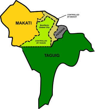
The local city governments of Makati and Taguig of the Philippines were involved in a territorial dispute. The cities claimed jurisdiction over Fort Bonifacio, which includes the financial district of Bonifacio Global City (BGC) and Enlisted Men’s Barrios (Embo) barangays.

Makati's 2nd congressional district is one of the congressional districts of the Philippines in the cities of Makati and Taguig. It has been represented in the House of Representatives of the Philippines since 1998. It is one of the two districts comprising Makati and, following the Makati–Taguig boundary dispute, as one of the three districts comprising Taguig. The district consists of eastern Makati barangays of Guadalupe Nuevo, Guadalupe Viejo, and Pinagkaisahan, along with the northwestern Taguig barangays of Cembo, Comembo, East Rembo, Pembo, Pitogo, Post Proper Northside, Post Proper Southside, Rizal, South Cembo and West Rembo, collectively known as the Embo barangays that were part of Makati until 2023. It is currently represented in the 19th Congress by Luis Jose Angel Campos Jr. of the Nationalist People's Coalition (NPC).

Embo, which stands for Enlisted Men's Barrio, refers to a collective term for ten barangays in Taguig, Philippines. The barangays were originally established to house military personnel of the Armed Forces of the Philippines (AFP). The area were formerly disputed between the cities of Makati and Taguig, as well as the municipality of Pateros. As of November 2023, the barangays were transferred from Makati to Taguig.
West Rembo, previously known as Barangay 16, is a barangay in Taguig, Metro Manila, Philippines. It is one of the ten barangays collectively known as the Embo barangays. It borders the Pasig River and the city of Pasig on its north, East Rembo on its east, Cembo on its west, and barangays Fort Bonifacio and Post Proper Northside on its south.


