Makati, officially the City of Makati, is a highly urbanized city in the National Capital Region of the Philippines, known for being one of the leading financial center in the country. As of 2013, the city has the highest concentration of multinational and local corporations in the Philippines. Major banks, corporations, department stores as well as foreign embassies are based in Makati. Makati is also known for being a major cultural and entertainment hub in Metro Manila. According to the 2020 census, it had a population of 629,616 people, making it as the 47th most populous city in the country and ranked as the 43rd most densely populated city in the world with 19,336 inhabitants per square kilometer or 50,080 inhabitants per square mile. In 2023, ten eastern barangays were removed from Makati's jurisdiction as a result of the Makati–Taguig boundary dispute ruling, resulting in a reduction of the city's population to 292,743. Although its population was just above half a million, the daytime population of the city is estimated to be more than three million during a typical working day because of the large number of people who go to the city to work, shop, and do business.

Biliran, officially the Province of Biliran, is an island province in the Philippines located in the Eastern Visayas region. Biliran is one of the country's smallest and newest provinces. Formerly a sub-province of Leyte, it became an independent province in 1992.

Pateros, officially the Municipality of Pateros, is the lone municipality of Metro Manila, Philippines. According to the 2020 census, it has a population of 65,227 people.

Taguig, officially the City of Taguig, is the fifth-most populous city in the Philippines with a population of 1.2 million people. The city is one of the Philippines' cultural, financial, high-tech, entertainment and media centers with significant influence on commerce, health care, research, technology, education, politics, tourism, dining, art, fashion, and sports. Taguig is also an important center for the country's international diplomacy, hosting several embassies. It is also home to the headquarters of several major multinational corporations.

Navotas, officially the City of Navotas, is a 1st class highly urbanized city in the National Capital Region of the Philippines. According to the 2020 census, it has a population of 247,543 people.

Rosario, officially the Municipality of Rosario, is a 1st class municipality in the province of Cavite, Philippines. According to the 2020 census, it has a population of 110,807 people.

General Trias, officially the City of General Trias, formerly known as San Francisco de Malabon is a 1st class component city in the province of Cavite, Philippines. According to the 2020 census, it has a population of 450,583 people.
Lezo, officially the Municipality of Lezo, is a 5th class municipality in the province of Aklan, Philippines. It is the smallest municipality in the province both by population and by land area, and even by revenue. According to the 2020 census, it has a population of 15,639 people.

Binalbagan, officially the Municipality of Binalbagan, is a 1st class municipality in the province of Negros Occidental, Philippines. According to the 2020 census, it has a population of 71,407 people.

Pililla, officially the Municipality of Pililla, is a 1st class municipality in the province of Rizal, Philippines. According to the 2020 census, it has a population of 71,535 people. It is surrounded by farms, small mountains, plains, and trees. Pililla is known as the Green Field Municipality of Rizal.

Mendez, officially the Municipality of Mendez-Nuñez, is a 4th class municipality in the province of Cavite, Philippines. According to the 2020 census, it has a population of 34,879 people.

Balasan, officially the Municipality of Balasan, is a 4th class municipality in the province of Iloilo, Philippines. According to the 2020 census, it has a population of 35,064 people.

Mina, officially the Municipality of Mina, is a 5th class municipality in the province of Iloilo, Philippines. According to the 2020 census, it has a population of 24,042 people.

Laguindingan, officially the Municipality of Laguindingan, is a 4th class municipality in the province of Misamis Oriental, Philippines. According to the 2020 census, it has a population of 26,363 people.

Tunga, officially the Municipality of Tunga, is a 6th class municipality in the province of Leyte, Philippines. According to the 2020 census, it has a population of 7,656 people.

Carmona is one of the 23 barangays of Makati. It is located in the northern part of the city. It is a residential area with a population of 2,745 as of the 2020 census, making it the least populous barangay in the city. The barangay was named after Comandante Isidro Carmona, a Filipino soldier who fought during the Philippine Revolution against the Spaniards.

Zobel Roxas Street is an east-west street that forms the southeastern limit of the City of Manila, the northwestern city limit of Makati, and the northern city limit of Pasay, all in Metro Manila, Philippines. It stretches across western Metro Manila from F. Muñoz Street in the Singalong area of Malate to Tejeron Street at the district boundary of San Andres Bukid and Santa Ana. It has a short extension northeast of the Tejeron Street–J.P. Rizal Avenue junction as Del Pan Street.

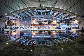
The Makati Central Business District is a financial and central business district in the Philippines located in the heart of Makati in Metro Manila. It is politically known as "Central Cluster" in the West District of Makati. It is different from the Makati civic center known as "Makati Poblacion" which is situated at the northeast portion of the district. It is bounded by EDSA, Amorsolo Street, Ayala Avenue, Gil Puyat Avenue, Osmeña Highway, Zobel Roxas Street, Ocampo Street, Metropolitan Avenue, Nicanor Garcia Street, Kalayaan Avenue, Makati Avenue, Anza Street, Polaris Street, Orion Street, Mercedes Street, Amapola Street and Estrella Street. The whole district occupies barangays of San Antonio, San Lorenzo, Bel-Air, and Urdaneta.

Santo Niño is an administrative division in southern Metro Manila, the Philippines. It is a barangay in the city of Parañaque immediately surrounding Ninoy Aquino International Airport on its west and south sides. A large portion of the village extends into the property of the airport grounds to include Terminal 1 as well as the western half of Runway 06/24. The village has a total land area of 245.97 hectares of which about 55% is occupied by the airport complex. Its population is concentrated in the areas along the Estero de Tripa de Gallina.

Makati's 1st congressional district is one of the two congressional districts of the Philippines in the city of Makati. It has been represented in the House of Representatives of the Philippines since 1998. The district consists of barangays in western Makati, namely Bangkal, Bel-Air, Carmona, Dasmariñas, Forbes Park, Kasilawan, La Paz, Magallanes, Olympia, Palanan, Pio del Pilar, Poblacion, San Antonio, San Isidro, San Lorenzo, Santa Cruz, Singkamas, Tejeros, Urdaneta, and Valenzuela. It is currently represented in the 19th Congress by Romulo Peña Jr. of the Liberal Party (LP).