
Las Piñas (Tagalog:[lasˈpiɲɐs], officially the City of Las Piñas, is a 1st class highly urbanized city in the National Capital Region of the Philippines. According to the 2020 census, it has a population of 606,293 people.

Taguig, officially the City of Taguig, is a coastal metropolis located in eastern shores of Metro Manila. It is the fifth-most populous city in the Philippines with a population of 1.2 million people. The city is one of the Philippines' cultural, financial, high-tech, entertainment and media centers with significant influence on commerce, health care, research, technology, education, politics, tourism, dining, art, fashion, and sports. Taguig is also an important center for the country's international diplomacy, hosting several embassies. The city also home to the headquarters of several major multinational corporations. Taguig has the fourth largest skyline in the Philippines, with 289 high-rises, 80 of which exceed 100 m (328 ft).

San Pedro, officially the City of San Pedro, is a 3rd class component city in the province of Laguna, Philippines. According to the 2020 census, it has a population of 326,001 people.
Namayan, also called Sapa, Maysapan, and sometimes Lamayan, was an independent indigenous polity on the banks of the Pasig River in the Philippines. It is believed to have achieved its peak in 1175, and to have gone into decline sometime in the 13th century, although it continued to be inhabited until the arrival of European colonizers in the 1570s.
Bulacan is a province of the Philippines. It was established on 15 August 1578.

Isla de la Convalecencia, commonly known as simply Isla de Convalecencia, is a small narrow river island in the Pasig River in Manila, the Philippines. It is the only island dividing the Pasig River in Manila located between the districts of San Miguel on the north bank, and Ermita and Paco on the south. The island, best known as the location of the Hospicio de San José, is administratively part of San Miguel's Barangay 646, Zone 67. It has a total area of approximately 594 square meters (6,390 sq ft) and is connected to both sides of the river by the Ayala Bridge.

The following is an alphabetical list of articles related to the Philippine capital region of Metro Manila.

Tunasan is a barangay in Muntinlupa, Philippines. It is the southernmost barangay of Metro Manila located in the southern section of the city bordering the province of Laguna. The total land area of the barangay is 9.596 km2 (3.705 sq mi), the largest in the city. According to the 2020 census, it has a population of 61,374.
New Lower Bicutan is one of the 38 barangays of Taguig, Metro Manila, Philippines. It was created into a barangay under Taguig City Ordinance No. 24, Series 2008 and ratified on December 18, 2008.

Bagumbayan is one of the 38 barangays of Taguig, Metro Manila in the Philippines. It is also one of the nine original Barrio of Taguig.

Bambang is one of the 38 barangays of Taguig, Metro Manila in the Philippines. One of the 9 initial Barrio of Taguig.

The National Shrine of Saint Joseph, commonly known as Mandaue Church, is a Roman Catholic parish church located at the center of Mandaue City, Philippines. The parish jurisdiction covers the civil barangays of Guizo, Centro, Looc, and Mantuyong.
Napindan is one of the 38 barangays of Taguig, Metro Manila, Philippines. One of the 18 barangay of Taguig when it became a part Metropolitan Manila on November 7, 1975.

San Martin de Porres is an administrative division in southern Metro Manila, the Philippines. It is an elongated barangay located in the northeast corner of Parañaque adjoining the areas of Bicutan in Taguig and northern Muntinlupa. It is unique in that it is connected to the rest of Parañaque by only two bridges, one of which is a footbridge. Its western border follows the South Luzon Expressway, thus separating it from Merville, Sun Valley, Don Bosco and Marcelo Green. It neighbors Western Bicutan to the north, particularly the redevelopment area of the former Food Terminal Inc. (FTI) known as Arca South. To the east, it adjoins Taguig's barangays of Upper Bicutan, Central Bicutan, North Daang Hari and Tanyag. It neighbors South Daang Hari and Sucat, Muntinlupa to the south.

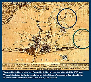
Santa Ana is one of the 38 barangays of Taguig, Metro Manila, Philippines. It is one of the nine original barrios of Taguig. It is named after Saint Anne, who is the patroness of the barangay.

Taguig–Pateros's 1st congressional district is one of the two congressional districts of the Philippines in the combined independent local government units of Pateros and Taguig. It has been represented in the House of Representatives of the Philippines since 2007. The district was created in 2004 following a plebiscite to ratify Republic Act No. 8487 or the 1998 Taguig City Charter. It consists of the entire municipality of Pateros and the eastern Taguig barangays of Bagumbayan, Bambang, Calzada, Hagonoy, Ibayo-Tipas, Ligid-Tipas, Lower Bicutan, New Lower Bicutan, Napindan, Palingon, San Miguel, Santa Ana, Tuktukan, Ususan and Wawa. The district is currently represented in the 19th Congress by Ricardo S. Cruz Jr. of the Nacionalista Party (NP).

Taguig–Pateros's 2nd congressional district is one of the two congressional districts of the Philippines in the combined independent local government units of Pateros and Taguig. The district is located entirely within the city of Taguig. It has been represented in the House of Representatives of the Philippines since 2007. The district was created in 2004 following a plebiscite to ratify Republic Act No. 8487 or the 1998 Taguig City Charter. It consists of the western Taguig barangays of Central Bicutan, Central Signal Village, Fort Bonifacio, Katuparan, Maharlika Village, North Daang Hari, North Signal Village, Pinagsama, South Daang Hari, South Signal Village, Tanyag, Upper Bicutan and Western Bicutan. The district is currently represented in the 19th Congress by Amparo Maria J. Zamora of the Nacionalista Party (NP).

The Royal Company of the Philippines was a chartered company founded in 1785, directed to establish a monopoly on the Spanish Philippines and all surrounding trade. It weakened in importance until it was dissolved in the 1830s. Its direct predecessor was that of the Guipuzcoan Company of Caracas.

Ususan is one of the 38 barangays of Taguig, Metro Manila, Philippines.
Local elections are scheduled to be held in Taguig on May 12, 2025, as part of the 2025 Philippine general election. The electorate will elect a mayor, a vice mayor, sixteen members of the Taguig City Council, and two district representatives to the House of Representatives of the Philippines. The officials elected in the election will assume their respective offices on June 30, 2025, for a three-year-long term.

