Stockwood

Last updated

Stockwood
Bristol stockwood.png
Boundaries of the city council ward.
Population10,802  [1]
OS grid reference ST624685
Unitary authority
Ceremonial county
Region
Country England
Sovereign state United Kingdom
Post town BRISTOL
Postcode district BS14
Dialling code 01275
Police Avon and Somerset
Fire Avon
Ambulance South Western
UK Parliament
List of places
UK
England
Bristol
51°24′53″N2°32′28″W / 51.4147°N 2.5410°W / 51.4147; -2.5410

Stockwood is a residential area and council ward in south Bristol, between Whitchurch and Brislington, and west of the Somerset town of Keynsham.

Contents

Geography

Stockwood forms an outermost southern suburb of the city with much green space; the upper part of Stockwood is set on a plateau surrounded by pasture and the lower part a wooded valley, bordered to its west by the old Bristol and North Somerset Railway rail line which is now a cycle way. [2]

The upper estate was built in the 1960s as private housing, [3] together with sheltered elderly accommodation. [4]

On a green-space ridge in front of the pantile-style shopping-precinct there is a good view of the city and events such as the Bristol International Balloon Fiesta. Below this green space, the rest of Stockwood consists of an earlier estate of previous council housing set on the sides of a steep valley. [5]

Community

Christ the Servant church in Stockwood, Bristol. Christ the Servant.jpg
Christ the Servant church in Stockwood, Bristol.

Population of about 11,800. [6]

There are two public houses located in Stockwood: The Concorde on Stockwood Lane and The Harvesters on Harrington Road. The uniquely named 'Man in Space' pub was redeveloped to make way for more residential houses and The Antelope was redeveloped to make way for flats. [7]

There are two churches on this upper area: Stockwood Free Church (Baptist) [8] and Christ the Servant (Anglican). [9] There is also a public library, clinic, dentistry practice, vet, optician and pharmacies at the upper shops, together with several different fast-food outlets.

There is a Stockwood Community Facebook Page, where members of the Stockwood community can connect with one another, local businesses and events. [10]

Sport

Bristol Telephones F.C. and Bristol Telephone Area RFC play at the BTRA Sports Ground on Stockwood Lane. Bristol Telephones FC are members of the Western Football League Division One. The Phones Rugby Team play in Somerset RFU Division II North. The Club is open to non-members and holds regular events such as Stockfest a yearly Music festival and an annual Firework Night. There are stables and horse riding as well as the nearby Horseworld. There is indoor bowls and other social activities at the Anglican Church. There are two Community Centres. Stockwood is home to Stockwood womens football team who play at the Blueprint stadium, BS14 8SJ. They play in the Eastern Division of the South West Regional Women's Football League. The nearest cricket club is St Mary Redcliffe CC who play at Old Reds Rugby Club off Scotland Lane.

Youth

There are local Scout and Guides and a Church Lads' and Church Girls' Brigade. There are two primary schools serving the area as well as nurseries.

Stockwood Open Space

Stockwood Open Space is a local nature reserve. [11] [12] It is an expanse of old farmland and ancient woodland providing a blend of old meadows, thick hedges and woodlands on lime-rich clay soils. It is owned by Bristol City Council and managed as a nature reserve in partnership with the Avon Wildlife Trust. cowslip, Dyer's greenweed, common spotted orchids and bird's-foot trefoil are amongst the flowers to be found, and numerous butterflies include meadow brown, marbled white and large skipper. The wood known as Ilsyngrove is very old and the home of bluebell, yellow archangel and the rare Bath asparagus. Birds including whitethroats, kestrels and sparrowhawks are often seen. Two farm ponds are homes for frogs, toads and newts. [13]

Related Research Articles

<span class="mw-page-title-main">Bradley Stoke</span> Town near Bristol, England

Bradley Stoke is a town in South Gloucestershire, England, situated 6 miles northeast of Bristol, It is near the Severn Estuary of the Bristol Channel, which is an extension of the North Atlantic Ocean, separating South Wales from South West England. Bradley Stoke is bordered by three motorways; the M5 to the north, the M4 to the east and the M32 to the south.

<span class="mw-page-title-main">Keynsham</span> Town and civil parish in Somerset, England

Keynsham is a town and civil parish located between Bristol and Bath in Somerset, England. It had a population of 19,603 at the 2021 Census. It was listed in the Domesday Book as Cainesham, which is believed to mean the home of Saint Keyne.

<span class="mw-page-title-main">Portishead, Somerset</span> Town in Somerset, England

Portishead is a town and civil parish in the North Somerset unitary authority area, in the county of Somerset, England. The town has a population of 27,000 and is located next to the Severn Estuary opposite Cardiff and Newport in Wales. The town is 8 miles (13 km) to the west of Bristol and 18 miles northeast of Weston-super-Mare.

<span class="mw-page-title-main">Backwell</span> Village in Somerset, England

Backwell is a village and civil parish in the unitary authority of North Somerset and in 2011 had a population of 4,589. The village lies about 7 miles (11 km) southwest of Bristol, south of the A370 to Weston-super-Mare. The parish includes the hamlets of Backwell Common, Backwell Green, and Backwell Farleigh, and the districts of Backwell West Town and Downside.

<span class="mw-page-title-main">Long Ashton</span> Human settlement in England

Long Ashton is a village and civil parish in Somerset, England. It falls within the unitary authority of North Somerset and is one of a number of large villages just outside the boundary of city of Bristol urban area. The parish has a population of 6,044. The parish includes the hamlet of Yanley, and the residential area of Leigh Woods.

The Avon Wildlife Trust aims to protect and promote wildlife in the area of the former county of Avon — now Bath and North East Somerset, Bristol, North Somerset and South Gloucestershire, in England. It has its headquarters in Bristol and runs wildlife centres at Folly Farm, Somerset and Grow Wilder, Frenchay, North Bristol.

<span class="mw-page-title-main">Midsomer Norton</span> Town in Somerset, England

Midsomer Norton is a town near the Mendip Hills in Bath and North East Somerset, England, 10 miles (16 km) south-west of Bath, 10 miles (16 km) north-east of Wells, 10 miles (16 km) north-west of Frome, 12 miles (19 km) west of Trowbridge and 16 miles (26 km) south-east of Bristol. It has a population of around 13,000. Along with Radstock and Westfield it used to be part of the conurbation and large civil parish of Norton Radstock, but is now a town council in its own right. It is also part of the unitary authority of Bath and North East Somerset.
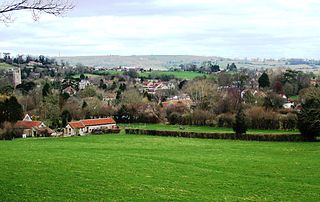
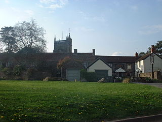
<span class="mw-page-title-main">Bedminster, Bristol</span> District of Bristol, England

Bedminster is a district of Bristol, England, on the south side of the city. It is also the name of a council ward which includes the central part of the district.

<span class="mw-page-title-main">Totterdown</span> Human settlement in England

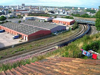
Totterdown is an inner-suburb of Bristol, England, situated just south of the River Avon and to the south-east of Temple Meads railway station and the city centre.

<span class="mw-page-title-main">Easton in Gordano</span> Village in Somerset, England

Easton in Gordano is a village in Somerset, England, about 4+12 miles (7 km) northwest of Bristol city centre. It is part of the civil parish of Pill and Easton-in-Gordano and within the unitary authority of North Somerset. In 2011 the population of the parish was 4,828.

<span class="mw-page-title-main">Twerton</span> Electoral ward in Bath, United Kingdom

Twerton is a suburb of the city of Bath, Somerset, England, situated to the west of the city, and home to the city's football club, Bath City.

<span class="mw-page-title-main">Whitchurch, Bristol</span> Human settlement in England

Whitchurch is a village in north Somerset, England and an adjoining suburb of southern Bristol, bounded by Hartcliffe to the west and Hengrove and Knowle to the north. The suburb was initially developed during the 1930s.

<span class="mw-page-title-main">Brickhill</span> Human settlement in England

Brickhill is a civil parish and electoral ward within northern Bedford in Bedfordshire, England.

<span class="mw-page-title-main">Churchill, Somerset</span> Village and civil parish in Somerset, England

Churchill is a village and civil parish in the unitary authority of North Somerset, part of the ceremonial county of Somerset. It is located on the western edge of the Mendip Hills, about 8 miles (12.9 km) east of Weston-super-Mare, and about 15 miles (24.1 km) south-west of Bristol. The parish, which includes the village of Lower Langford and the hamlet of Upper Langford, has a population of 2,250.

<span class="mw-page-title-main">Bishop Sutton</span> Human settlement in England

Bishop Sutton is a village on the northern slopes of the Mendip Hills, within the affluent Chew Valley in Somerset. It lies east of Chew Valley Lake and north east of the Mendip Hills, approximately ten miles south of Bristol on the A368, Weston-super-Mare to Bath road between West Harptree and Chelwood. Bishop Sutton and the neighbouring village of Stowey form the civil parish of Stowey Sutton.

<span class="mw-page-title-main">Winford</span> Human settlement in England

Winford is a village and civil parish within the Chew Valley, Somerset, England. It is within the unitary authority of North Somerset about 8 miles (12.9 km) south of Bristol. The parish has a population of 2,153.

<span class="mw-page-title-main">Parks of Bristol</span>

The English city of Bristol has a number of parks and public open spaces.

<span class="mw-page-title-main">Hinton Blewett</span> Human settlement in England

Hinton Blewett is a village and civil parish in Somerset, England, 5 miles (8.0 km) north of Wells and 15 miles (24.1 km) south of Bristol on the northern slope of the Mendip Hills, within the designated Area of Outstanding Natural Beauty (AONB) and in the Chew Valley near the source of the River Chew. The parish has a population of 308.

South Bristol is the part of Bristol, England south of the Bristol Avon. It is almost entirely made up of the areas of the city historically in Somerset, and since the abolition of the county Avon, consists of the southern suburbs in the county of Bristol. Definitions sometimes also include areas of North Somerset, including Long Ashton, Nailsea and Backwell.

References

  1. "Stockwood" (PDF). 2011 Census Ward Information Sheet. Retrieved 26 February 2015.
  2. "Chapter 18 - Strategy Area: Dundry and River Valleys" (PDF). Forest of Avon Trust. Retrieved 26 August 2018.
  3. "Stockwood". Ocean Home. Retrieved 26 August 2018.
  4. "£8m housing scheme tops out". bbp media. Retrieved 26 August 2018.
  5. "The Nineteenth- and Twentieth-Century Public House in Bristol". English Heritage. pp. 318–320. Retrieved 26 August 2018.
  6. "Stockwood Statistical Ward Profile 2017 June 2017". Bristol City Council. Retrieved 26 August 2018.
  7. "Stockwood pubs and bars; pubs in Stockwood, Bristol". Beer in the Evening. Retrieved 26 August 2018.
  8. "Stockwood Free Church (Baptist)". West of England Baptist Association. Retrieved 26 August 2018.
  9. "Christ the Servant". A Church Near You. Church of England. Retrieved 26 August 2018.
  10. "Stockwood community (Bristol)". Facebook. Retrieved 26 August 2018.
  11. "Stockwood Open Space". Local Nature Reserves. Natural England. Retrieved 4 August 2013.
  12. "Map of Stockwood Open Space". Local Nature Reserves. Natural England. Retrieved 4 August 2013.
  13. "Stockwood Open Space". Reserves. Avon Wildlife Trust. Retrieved 27 October 2015.