Swamp Creek (Wisconsin)

Last updated
The Turtle-Flambeau Flowage, pictured here, is located near Swamp Creek in the Flambeau River's northern watershed. Turtle-Flambeau Flowage.JPG
The Turtle-Flambeau Flowage, pictured here, is located near Swamp Creek in the Flambeau River's northern watershed.

Swamp Creek is a tributary of the Flambeau River in northern Wisconsin, USA. [1] The Flambeau is in turn a tributary of the Chippewa River.

Tributary stream or river that flows into a main stem river or lake

A tributary or affluent is a stream or river that flows into a larger stream or main stem river or a lake. A tributary does not flow directly into a sea or ocean. Tributaries and the main stem river drain the surrounding drainage basin of its surface water and groundwater, leading the water out into an ocean.

Flambeau River river in the United States of America

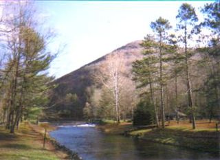
The Flambeau River is a tributary of the Chippewa River in northern Wisconsin, United States. The Chippewa is in turn a tributary of the upper Mississippi River. The Flambeau drains an area of 1,860 square miles (4,800 km2) and descends from an elevation of approximately 1,570 feet (480 m) to 1,060 feet (320 m) above sea level. The Flambeau is an important recreational destination in the region. It is notable among canoeists in the Midwest for outstanding canoe camping, including excellent scenery, fishing and whitewater. The river and its forks have a variety of possible trip lengths from short day outings, to overnight camping, to voyages of a week or more.

Wisconsin A north-central state of the United States of America

Wisconsin is a U.S. state located in the north-central United States, in the Midwest and Great Lakes regions. It is bordered by Minnesota to the west, Iowa to the southwest, Illinois to the south, Lake Michigan to the east, Michigan to the northeast, and Lake Superior to the north. Wisconsin is the 23rd largest state by total area and the 20th most populous. The state capital is Madison, and its largest city is Milwaukee, which is located on the western shore of Lake Michigan. The state is divided into 72 counties.

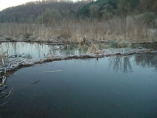
Swamp Creek is the largest of 23 streams which flow into the Flambeau River, and one of a few which have a dam. The other remaining tributaries of the Flambeau River are fairly small, but many support trout populations. [2]

Dam A barrier that stops or restricts the flow of surface or underground streams

A dam is a barrier that stops or restricts the flow of water or underground streams. Reservoirs created by dams not only suppress floods but also provide water for activities such as irrigation, human consumption, industrial use, aquaculture, and navigability. Hydropower is often used in conjunction with dams to generate electricity. A dam can also be used to collect water or for storage of water which can be evenly distributed between locations. Dams generally serve the primary purpose of retaining water, while other structures such as floodgates or levees are used to manage or prevent water flow into specific land regions. The earliest known dam is the Jawa Dam in Jordan, dating to 3,000 BC.

Trout number of species of freshwater fish

Trout is the common name for a number of species of freshwater fish belonging to the genera Oncorhynchus, Salmo and Salvelinus, all of the subfamily Salmoninae of the family Salmonidae. The word trout is also used as part of the name of some non-salmonid fish such as Cynoscion nebulosus, the spotted seatrout or speckled trout.

The Flambeau River rises in two major forks—the North Fork and the South Fork. Swamp Creek is located in the watershed of the North Fork, which is near the Turtle-Flambeau Flowage in Iron County. Swamp Creek is one of four other named creeks in the watershed of the North Fork, the others being Bosner Creek, Smith Creek, and Sixmile Creek. [3]

Drainage basin Area of land where precipitation collects and drains off into a common outlet

A drainage basin is any area of land where precipitation collects and drains off into a common outlet, such as into a river, bay, or other body of water. The drainage basin includes all the surface water from rain runoff, snowmelt, and nearby streams that run downslope towards the shared outlet, as well as the groundwater underneath the earth's surface. Drainage basins connect into other drainage basins at lower elevations in a hierarchical pattern, with smaller sub-drainage basins, which in turn drain into another common outlet.

Turtle-Flambeau Flowage lake of the United States of America

The Turtle-Flambeau Flowage is a 12,942 acre lake, located in Iron County, Wisconsin. It has a maximum depth of 50 feet. Fish include Musky, Panfish, Largemouth Bass, Smallmouth Bass, Northern Pike, Walleye and Sturgeon. The lake's water clarity is low.

Iron County, Wisconsin county in Wisconsin, United States

Iron County is a county located in the U.S. state of Wisconsin. As of the 2010 census, the population was 5,916, making it the third-least populous county in Wisconsin. Its county seat is Hurley. It was named for the valuable iron ore found within its borders.

Forest Wander Lake 17 is a 39-acre impoundment of Swamp Creek in Iron County. [4]

Most of Swamp Creek is classified as a Class II Trout Stream. [5] Streams in this classification may have some natural reproduction, but not enough to utilize available food and space. Therefore, stocking is required to maintain a desirable sport fishery. These streams have good survival and carryover of adult trout, often producing some fish larger than average size. There are 5,911.6 miles of Class 2 trout streams in Wisconsin and they comprise 45% of Wisconsin's total trout stream mileage. [6]

Related Research Articles

Kickapoo River river in the United States of America

The Kickapoo River is a 126-mile-long (203 km) tributary of the Wisconsin River in the state of Wisconsin, United States. It is named for the Kickapoo Indians who occupied Wisconsin before the influx of white settlers in the early 19th century.

Bitterroot River river in the United States of America

The Bitterroot River is a northward flowing 84 miles (135 km) river running through the Bitterroot Valley, from the confluence of its West and East forks near Conner in southern Ravalli County to its confluence with the Clark Fork River near Missoula in Missoula County, in western Montana. The Clark Fork River is tributary to the Columbia River and ultimately, the Pacific Ocean. The Bitterroot River is a Blue Ribbon trout fishery with a healthy population of native westslope cutthroat trout and bull trout. It is the third most fly fished river in Montana behind the Madison and Big Horn Rivers.

Larrys Creek tributary of the West Branch Susquehanna River

Larrys Creek is a 22.9-mile-long (36.9 km) tributary of the West Branch Susquehanna River in Lycoming County in the U.S. state of Pennsylvania. A part of the Chesapeake Bay drainage basin, its watershed drains 89.1 square miles (231 km2) in six townships and a borough. The creek flows south from the dissected Allegheny Plateau to the Ridge-and-valley Appalachians through sandstone, limestone, and shale from the Devonian, Mississippian, and Pennsylvanian periods.

Kettle Creek (Pennsylvania) tributary of the West Branch Susquehanna River

Kettle Creek is a tributary of the West Branch Susquehanna River running through Tioga, Potter, and Clinton counties, in Pennsylvania. It is slightly less than 43 miles (69 km) long. Although many streams in the Kettle Creek watershed are considered "Class A Wild Trout streams" by the Pennsylvania Fish and Boat Commission, the lower reaches of the stream experience acid mine drainage. The upper reaches of the creek are considered to be very high-quality.

Mehoopany Creek tributary of the Susquehanna River

Mehoopany Creek is a tributary of the Susquehanna River in Sullivan and Wyoming counties, Pennsylvania, in the United States. It is approximately 26.8 miles (43.1 km) long. In Sullivan County the creek flows through Colley Township and in Wyoming County it flows through Forkston Township and Mehoopany Township. The stream's watershed has an area of 123 square miles (320 km2). Its major tributaries include Stony Brook and North Fork Mehoopany Creek.

Whitewater River (Minnesota) tributary of the Upper Mississippi River in Minnesota

The Whitewater River is a 16.6-mile-long (26.7 km) tributary of the Upper Mississippi River which flows through the Driftless Area of Minnesota, reaching its mouth in Wabasha County at the community of Weaver opposite Buffalo, Wisconsin. The nearest towns are Altura, Saint Charles, and Elba. The region hosts endangered native dry oak savannas, semiforested areas that seem to have been dependent on fire for their well-being.

The West Branch Sugar River is a tributary of the Sugar River, about 22.3 miles (36 km) long, in south central Wisconsin in the United States. Via the Sugar, Pecatonica, and Rock Rivers, it is part of the watershed of the Mississippi River. Its watershed lies entirely within Dane County.

The Clam River is a 63.4-mile-long (102.0 km) tributary of the St. Croix River in northwestern Wisconsin in the United States. In its history, it has been known by the names Kayeskikan, Kiesca-seba, and "Shell River".

Tangascootack Creek tributary of the West Branch Susquehanna River

Tangascootack Creek is a tributary of the West Branch Susquehanna River in Clinton County, Pennsylvania in the United States. Tangascootack Creek stretches for 8.48 miles (13.65 km) through Bald Eagle, Beech Creek and Colebrook Townships. Its watershed covers 36.5 square miles. Among its tributaries are North Fork Tangascootack Creek and Muddy Run, and there is also a swamp called Bear Swamp near the headwaters. Coal mining, including strip mining, was common in the watershed throughout the 1800s and 1900s. The creek experiences acid mine drainage, much of which comes from Muddy Run.

Twomile Run is a tributary of Kettle Creek in Clinton County, Pennsylvania, in the United States. It is 4.5 miles (7.2 km) long. Tributaries of the stream include Huling Branch and Middle Branch Twomile Run. The stream flows through Leidy Township and Noyes Township. The stream's watershed has an area of approximately 9 square miles. Coal is mined in the watershed. Most of the acid mine drainage in Kettle Creek comes from Twomile Run.

Hammersley Fork tributary of Kettle Creek in Potter and Clinton Counties, Pennsylvania

Hammersley Fork is a tributary of Kettle Creek in Potter County and Clinton County, Pennsylvania, in the United States. It is approximately 10.0 miles (16.1 km) long and flows through Warton Township in Potter County and Leidy Township in Clinton County. The watershed of the stream has an area of 32.7 square miles (85 km2). The main rock formation in the watershed is the Pottsville Formation. A number of bridges cross the stream.

North Fork Tangascootack Creek is a tributary of Tangascootack Creek in Clinton County, Pennsylvania, in the United States. It is 7.1 miles (11.4 km) long and flows through Beech Creek Township. The creek's watershed has an area of 19.2 square miles (50 km2). Its major tributaries include Mill Branch and Boiler Run. North Fork Tangascootack Creek does not experience much acid mine drainage and its trout and macroinvertebrate populations are sizeable. The creek is near the Slaughtering Ground Barrens.

Klingermans Run tributary of Catawissa Creek in Columbia County, Pennsylvania

Klingermans Run is a tributary of Catawissa Creek in Columbia County, Pennsylvania, in the United States. It is approximately 2.4 miles (3.9 km) long and flows through Roaring Creek Township and Beaver Township. The watershed of the stream has an area of 1.78 square miles (4.6 km2). The stream is considered to be a High-Quality Coldwater Fishery and Class A Wild Trout Waters. The main rock formations in the stream's watershed are the Mauch Chunk Formation and the Pocono Formation and the main soils are the Leck Kill soil and the Hazleton soil.

The South Fork of the Kinnickinnic River is a 7.1 mile-long tributary to the Kinnickinnic River in northwestern Wisconsin, USA.

Roaring Brook (Lackawanna River tributary)

Roaring Brook is a tributary of the Lackawanna River in Lackawanna County, Pennsylvania, in the United States. It is approximately 21 miles (34 km) long and flows through Covington Township, Madison Township, Moscow, Roaring Brook Township, Elmhurst Township, Dunmore, and Scranton. The watershed of the stream has an area of 56.3 square miles (146 km2). Its named tributaries include Little Roaring Brook, Rock Bottom Creek, White Oak Run, Van Brunt Creek, Bear Brook, and East Branch Roaring Brook. It has a high level of water quality for much of its length. However, it is affected by abandoned mining land, stormwater, and other impacts in its lower reaches. Reservoirs in the watershed include the Hollister Reservoir, the Elmhurst Reservoir, and others. The stream also flows through the Nay Aug Gorge and passes over the Nay Aug Falls, which are on the National Register of Geologic Landmarks. It flows through a concrete channel in its lower reaches. The topography of the watershed contains rolling hills in its upper reaches and the mountainous land of the Moosic Mountains in its lower reaches.

North Branch Mehoopany Creek is a tributary of Mehoopany Creek in Bradford County, Sullivan County, and Wyoming County, in Pennsylvania, in the United States. It is approximately 14 miles (23 km) long and flows through Wilmot Township in Bradford County, Colley Township in Sullivan County, and North Branch Township and Forkston Township. The watershed of the creek has an area of 40.0 square miles (104 km2). The creek has eight named direct tributaries, including hollows. In the 1940s and 1950s, the average discharge for September was found to be just 6.8 cubic feet per second (0.19 m3/s), but was found to be over 100 cubic feet per second (2.8 m3/s) for July and August.

References

  1. "Butternut Wisconsin Website" . Retrieved 19 May 2013.
  2. "North Fork - Flambeau River Watershed" (PDF). Wisconsin DNR. Retrieved 19 May 2013.
  3. "North Fork - Flambeau River Watershed" (PDF). Wisconsin DNR. Retrieved 19 May 2013.
  4. "North Fork - Flambeau River Watershed" (PDF). Wisconsin DNR. Retrieved 19 May 2013.
  5. "Wisconsin DNR website" . Retrieved 19 May 2013.
  6. "Wisconsin DNR website" . Retrieved 19 May 2013.