8th Street and St. Mark's Place

Last updated

Template:Attached KML/8th Street / St. Mark's Place (Manhattan)
KML is from Wikidata
8th Street/St. Mark's Place
St. Mark's Place
St. Marks Place.jpg
St. Mark's Place in 2010
8th Street and St. Mark's Place
Maintained by New York City Department of Transportation
Length1.3 mi (2.1 km) [1] [2]
Location Manhattan, New York City
ZIP Codes10003, 10009, 10011
West end Sixth/Greenwich Avenues in West/Greenwich Villages
East end Avenue D in East Village
North 9th Street
South Waverly Place (6th Avenue to Broadway)
7th Street (Bowery to Avenue D)
Construction
Commissioned March 1811

8th Street is a street in the New York City borough of Manhattan that runs from Sixth Avenue to Third Avenue, and also from Avenue B to Avenue D; its addresses switch from West to East as it crosses Fifth Avenue. Between Third Avenue and Avenue A, it is named St. Mark's Place, after the nearby St. Mark's Church in-the-Bowery on 10th Street at Second Avenue.

Contents

St. Mark's Place is considered a main cultural street for the East Village. Vehicular traffic runs east along both one-way streets. St. Mark's Place features a wide variety of retailers. Venerable institutions lining St. Mark's Place have included Gem Spa and the St. Mark's Hotel. There are several open-front markets that sell sunglasses, clothing, and jewelry. In her 400-year history of St. Mark's Place ( St. Marks Is Dead ), Ada Calhoun called the street "like superglue for fragmented identities" and wrote that "the street is not for people who have chosen their lives ... [it] is for the wanderer, the undecided, the lonely, and the promiscuous." [3]

History

Early years

Wouter van Twiller, colonial governor of New Amsterdam, once owned a tobacco farm near 8th and MacDougal Streets. Such farms were located around the area until the 1830s. [4] Nearby, a Native American trail crossed the island via the rights-of-way of Greenwich Avenue, Astor Place, and Stuyvesant Street. [4]

The Commissioners' Plan of 1811 defined the street grid for much of Manhattan. According to the plan, 8th Street was to run from Greenwich Lane (now Greenwich Avenue) in the west to First Avenue on the east. [5] [6] The area west of Greenwich Lane was already developed as Greenwich Village, while the area east of First Avenue was reserved for a wholesale food market.

The plan was amended many times as the grid took shape and public spaces were added or eliminated. The marketplace proposal was scrapped in 1824, allowing 8th Street to continue eastward to the river. [7] On the west side, Sixth Avenue was extended and Greenwich Lane shortened, shifting the boundary of 8th Street, ever so slightly, to Sixth Avenue and allowing Mercer, Greene, Wooster and MacDougal Streets to continue northward to 8th. [8] [9]

19th century

After the Commissioners' Plan was laid out, property along the street's right of way quickly developed. By 1835, the New York University opened its first building, the Silver Center, along Eighth Street near the Washington Square Park. Row houses were also built on Eighth Street. The street ran between the Jefferson Market, built in 1832 at the west end, and the Tompkins Market, built in 1836, at the east end. These were factors in the street's commercialization in later years. [4]

Eighth Street was supposed to extend to a market place at Avenue C, but since that idea never came to fruition. Capitalizing on the high-class status of Bond, Bleecker, Great Jones, and Lafayette Streets in NoHo, developer Thomas E. Davis developed the east end of the street and renamed it "St. Mark's Place" in 1835. [10] Davis built up St. Mark's Place between Third and Second Avenues between 1831 and 1832. Although the original plan was for Federal homes, only three such houses remained in 2014. [10]

Meanwhile, Eighth Street became home to a literary scene. At Astor Place and Eighth Street, the Astor Opera House was built by wealthy men and opened in 1847. [11] Publisher Evert Augustus Duyckinck founded a private library at his 50 East Eighth Street home. Ann Lynch started a famous literary salon at 116 Waverly Place and relocated to 37 West Eighth Street in 1848. [4] Around this time and up until the 1890s, Eighth Street was co-named Clinton Place in memory of politician DeWitt Clinton, whose widow lived along nearby University Place. [4]

In the 1850s, Eighth Street housed an educational scene as well. The Cooper Union for the Advancement of Science and Art, a then-free institution for art, architecture and engineering education, was opened in 1858. The Century Club, an arts and letters association, relocated to 46 East Eighth Street around that time; the Bible House of the American Bible Society, was nearby. In addition, the Brevoort Hotel, as well as a marble mansion built by John Taylor Johnston, were erected at Fifth Avenue and Eighth Street. [4]

At the same time, German immigrants moved into the area around Tompkins Square Park. The area around St. Mark's Place was nicknamed Kleindeutschland , or "Little Germany", because of a huge influx of German immigrants in the 1840s and 1850s. Many of the homes turned into boarding houses, as the area had 50,000 residents but not a lot of real estate. Tenement housing was also built on St. Mark's Place. [10]

By the 1870s, apartments replaced stables and houses along the stretch of Eighth Street west of MacDougal Street. The elevated Third and Sixth Avenue Lines were also built during that time, with stops along the former at Ninth Street and along the latter at Eighth Street. [4] [10]

Wanamaker Annex Wanamaker Annex.jpg
Wanamaker Annex

At the southwest corner of Broadway and Eighth Street, the street's first commercial building was built. By the 1890s, buildings on the stretch from Bowery to Fifth Avenue were used for trade. [4] In 1904, the Wanamaker's Department Store opened at the former A.T. Stewart store along Broadway between 9th and 10th Streets, with an annex built at Eighth Street. [4]

20th century

In the early 1900s, Little Germany was shrinking. At the same time, Jews, Hungarians, Poles, Ukrainians, and Russians from Eastern Europe started moving in. In 1916, Slovenian community and Franciscans established the Slovenian Church of St. Cyril, which still operates. [12] At this point, St. Mark's Place was considered a part of the Lower East Side. [10]

On the western stretch of Eighth Street, an art scene was growing. Gertrude Vanderbilt Whitney, Daniel Chester French, and other artists moved in the stables at MacDougal Alley at this time. By 1916, a studio complex for artists replaced most of these stables, making the areas around Eighth Street popular for bohemians. Whitney, a patron for other American painters, combined four houses on West Eighth Street houses into the Whitney Museum in 1931. [4]

The 1927 construction of the skyscraper at One Fifth Avenue, as well as the Eighth Street Playhouse movie theater, helped influence development on the Sixth Avenue end of the street, where construction of the IND Eighth Avenue Line had required destruction of many buildings there. [4] On an adjoining block, the Women's House of Detention was built in Jefferson Market complex in 1929–1932 and existed through the 1970s. [4]

In the 1930s, after Prohibition ended, West Eighth Street became an entertainment area. Around that time, the New York School movement for abstract expressionist painters was centered around Eighth Street, with many such painters moving to Eighth Street. [4]

After World War II, property along 8th Street was converted to apartment houses. The Rhinelander Estate, one of the major landowners on Eighth Street, erected a building between Washington Square North, Fifth Avenue, West Eighth Street, and the Whitney Museum site. Sailor's Snug Harbor, the other major land owner, demolished the blocks from Fifth Avenue to Broadway on the north side of Eighth and Ninth Streets, including the popular Brevoort Hotel. It replaced these blocks mainly with low-rise apartment buildings and stores, as well as two high-rises. [4] Around this time, West Eighth Street was also becoming the location of neighborhood commerce. [4]

After the elevated train lines were demolished in the 1940s and 1950s, the real estate industry tried to entice residents to the St. Mark's Place area, describing the neighborhood as "East Village". This area became home to an underground scene, and as it was far from public transportation, it became rundown. A 1965 Newsweek article described the East Village by telling readers to "head east from Greenwich Village, and when it starts to look squalid, around the Bowery and Third Avenue, you know you're there." [10]

In the 1960s, Macdougal and West Eighth Streets, as well as St. Mark's Place, became a popular area for hippies. [10] A women's clothing store, a pharmacy, and bookstores were replaced by fast food restaurants and other shops, directed toward the area's tourism base. [4] By 1968, St, Mark's Place became a stopping point for tour buses, which formerly skipped the area. [10]

In 1977, St. Marks Place became the epicenter of punk rock, when Manic Panic opened its doors on July 7, 1977 (7/7/77). [13] The shop quickly attracted musicians from Cyndi Lauper to the Ramones. [14]

In 1980, hot dog company Nathan's Famous moved into the location of a former bookstore on Eighth Street, to the anger of some Greenwich Village residents. However, other establishments, such as the B. Dalton bookstore, clothing stores, and shoe stores, started to attract tourists to the area. [4] By the 1990s, the areas around both Eighth Street and St. Mark's Place were becoming rapidly gentrified, with new buildings and establishments being developed along both streets. [10] The Village Alliance Business Improvement District was formed in 1993 to care for the area around Eighth Street. [4]

Notable buildings and sites

295 East 8th Street entrance.jpg
The entrance to 295 East 8th Street, with "Talmud Torah Darchei Noam" above the door
WTM tony 0058.jpg
Marlton House in 2008
The original location of the Whitney Museum, three converted townhouses at 8-12 West 8th Street Whitney Museum 8-12 West 8th Street.jpg
The original location of the Whitney Museum, three converted townhouses at 8–12 West 8th Street

8th Street

East

West

Hamilton-Holly House.jpg
Hamilton-Holly House (#4) was part of the same 1830s development as...
Daniel-leroy-house-20-st-marks.jpg
...the Daniel LeRoy House (#20); the developer was Thomas E. Davis. [22]
The German-American Shooting Society clubhouse at#12 Little Germany House.jpg
The German-American Shooting Society clubhouse at#12
Arlington Hall at#19-23, c.1892 Arlington Hall NYC.gif
Arlington Hall at#19–23, c.1892
Club-57.jpg
Club 57 at #57
Physical Led Zeppelin.jpg
The Physical Graffiti buildings at #96 & #98

St. Mark's Place

Rent Is Too Damn High Party car parked on St Mark's Place, where founder Jimmy McMillan lived until 2015 Loz rent car.JPG
Rent Is Too Damn High Party car parked on St Mark's Place, where founder Jimmy McMillan lived until 2015

Public transportation

Gem Spa was the "corner store" for locals for nearly a century before closing due to financial hardship during the COVID-19 pandemic. Gem Spa.jpg
Gem Spa was the "corner store" for locals for nearly a century before closing due to financial hardship during the COVID-19 pandemic.
Cherries, an adult store on St. Mark's Place whose signage was part of Saturday Night Live's opening montage. The store closed in late 2011. StMarks2.jpg
Cherries, an adult store on St. Mark's Place whose signage was part of Saturday Night Live's opening montage. The store closed in late 2011.

St. Mark's Place appears in a variety of works in popular culture. Notable examples include:

Music

Television

Film

See also

Related Research Articles

<span class="mw-page-title-main">Greenwich Village</span> Neighborhood of Manhattan in New York City

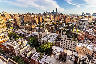
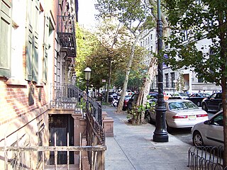
Greenwich Village, or simply the Village, is a neighborhood on the west side of Lower Manhattan in New York City, bounded by 14th Street to the north, Broadway to the east, Houston Street to the south, and the Hudson River to the west. Greenwich Village also contains several subsections, including the West Village west of Seventh Avenue and the Meatpacking District in the northwest corner of Greenwich Village.

<span class="mw-page-title-main">Chelsea, Manhattan</span> Neighborhood of Manhattan in New York City

Chelsea is a neighborhood on the West Side of the borough of Manhattan in New York City. The area's boundaries are roughly 14th Street to the south, the Hudson River and West Street to the west, and Sixth Avenue to the east, with its northern boundary variously described as near the upper 20s or 34th Street, the next major crosstown street to the north. To the northwest of Chelsea is the neighborhood of Hell's Kitchen, as well as Hudson Yards; to the northeast are the Garment District and the remainder of Midtown South; to the east are NoMad and the Flatiron District; to the southwest is the Meatpacking District; and to the south and southeast are the West Village and the remainder of Greenwich Village. Chelsea is named after the Royal Hospital Chelsea in London, England.

<span class="mw-page-title-main">Alphabet City, Manhattan</span> Neighborhood of Manhattan in New York City

Alphabet City is a neighborhood located within the East Village in the New York City borough of Manhattan. Its name comes from Avenues A, B, C, and D, the only avenues in Manhattan to have single-letter names. It is bounded by Houston Street to the south and 14th Street to the north, and extends roughly from Avenue A to the East River. Some famous landmarks include Tompkins Square Park, the Nuyorican Poets Cafe and the Charlie Parker Residence.

<span class="mw-page-title-main">NoHo, Manhattan</span> Neighborhood of Manhattan, New York City

NoHo, short for North of Houston Street, is a primarily residential neighborhood in Lower Manhattan in the New York City borough of Manhattan. It is bounded by Mercer Street to the west and the Bowery to the east, and from East 9th Street in the north to East Houston Street in the south.

<span class="mw-page-title-main">East Village, Manhattan</span> Neighborhood of Manhattan in New York City

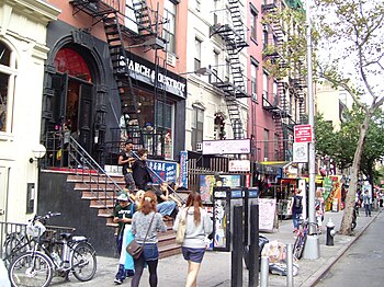
The East Village is a neighborhood on the East Side of Lower Manhattan in New York City, United States. It is roughly defined as the area east of the Bowery and Third Avenue, between 14th Street on the north and Houston Street on the south. The East Village contains three subsections: Alphabet City, in reference to the single-letter-named avenues that are located to the east of First Avenue; Little Ukraine, near Second Avenue and 6th and 7th Streets; and the Bowery, located around the street of the same name.

<span class="mw-page-title-main">Astor Place station</span> New York City Subway station in Manhattan

The Astor Place station, also called Astor Place–Cooper Union on signs, is a local station on the IRT Lexington Avenue Line of the New York City Subway. Located at Fourth Avenue, Cooper Square, and Astor Place between the East Village and NoHo, it is served by 6 trains at all times, <6> trains during weekdays in the peak direction, and 4 trains during late night hours.

<span class="mw-page-title-main">Astor Place</span> Street in Manhattan, New York

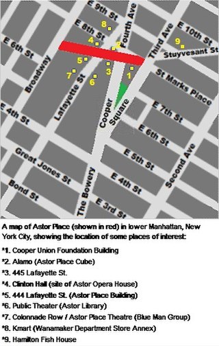
Astor Place is a one-block street in NoHo/East Village, in the lower part of the New York City borough of Manhattan. It runs from Broadway in the west to Lafayette Street. The street encompasses two plazas at the intersection with Cooper Square, Lafayette Street, Fourth Avenue, and Eighth Street – Alamo Plaza and Astor Place Station Plaza. "Astor Place" is also sometimes used for the neighborhood around the street. It was named for John Jacob Astor, soon after his death in 1848. A $21 million reconstruction to implement a redesign of Astor Place began in 2013 and was completed in 2016.

<span class="mw-page-title-main">Stuyvesant Street</span> Street in Manhattan, New York

Stuyvesant Street is one of the oldest streets in the New York City borough of Manhattan. It runs diagonally from 9th Street at Third Avenue to 10th Street near Second Avenue, all within the East Village, Manhattan, neighborhood. The majority of the street is included in the St. Mark's Historic District.

<span class="mw-page-title-main">Meatpacking District, Manhattan</span> United States historic place

The Meatpacking District is a neighborhood in the New York City borough of Manhattan that runs from West 14th Street south to Gansevoort Street, and from the Hudson River east to Hudson Street. The Meatpacking Business Improvement District along with signage in the area, extend these borders farther north to West 17th Street, east to Eighth Avenue, and south to Horatio Street.

<span class="mw-page-title-main">Eighth Avenue (Manhattan)</span> Avenue in Manhattan, New York

Eighth Avenue is a major north–south avenue on the west side of Manhattan in New York City, carrying northbound traffic below 59th Street. It is one of the original avenues of the Commissioners' Plan of 1811 to run the length of Manhattan, though today the name changes twice: At 59th Street/Columbus Circle, it becomes Central Park West, where it forms the western boundary of Central Park, and north of 110th Street/Frederick Douglass Circle, it is known as Frederick Douglass Boulevard before merging onto Harlem River Drive north of 155th Street.

<span class="mw-page-title-main">4th Street (Manhattan)</span> Northwest-southeast street in Manhattan, New York

4th Street is a street in Lower Manhattan, New York City. It starts at Avenue D as East 4th Street and continues to Broadway, where it becomes West 4th Street. It continues west until the Avenue of the Americas, where West 4th Street turns north and confusingly intersects with West 10th, 11th, 12th, and 13th Streets in Greenwich Village. Most of the street has the same 40-foot (12 m) width between curbstones as others in the prevailing street grid, striped as two curbside lanes and one traffic lane, with one-way traffic eastbound. The portion from Seventh to Eighth Avenues is westbound and is approximately 35 feet (11 m) wide, a legacy of the original Greenwich Village street grid. The section of four short blocks from MacDougal Street to University Place which forms the southern border of Washington Square Park is called Washington Square South.

Balducci's Food Lover's Market is a specialty gourmet food retailer in the Mid-Atlantic United States with eight grocery stores, owned by Albertsons since 2020.

<span class="mw-page-title-main">M8 (New York City bus)</span> Bus route in Manhattan, New York

The Eighth and Ninth Streets Crosstown is a public transit line in Manhattan, New York City, running mostly along Eighth Street, Ninth Street, Tenth Street, and Christopher Street through the West Village, Greenwich Village, and East Village. Originally a streetcar line, it is now the M8 bus route, operated by the New York City Transit Authority.

<span class="mw-page-title-main">Cooper Square</span> Square in Manhattan, New York

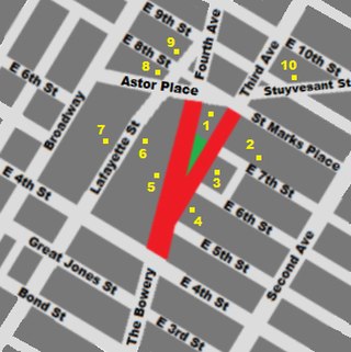
Cooper Square is a junction of streets in Lower Manhattan in New York City located at the confluence of the neighborhoods of Bowery to the south, NoHo to the west and southwest, Greenwich Village to the west and northwest, the East Village to the north and east, and the Lower East Side to the southeast.

<span class="mw-page-title-main">Lafayette Street</span> Street in Manhattan, New York

Lafayette Street is a major north–south street in New York City's Lower Manhattan. It originates at the intersection of Reade Street and Centre Street, one block north of Chambers Street. The one-way street then successively runs through Chinatown, Little Italy, NoLIta, and NoHo and finally, between East 9th and East 10th streets, merges with Fourth Avenue. A buffered bike lane runs outside the left traffic lane. North of Spring Street, Lafayette Street is northbound (uptown)-only; south of Spring Street, Lafayette is southbound (downtown)-only.

<span class="mw-page-title-main">St. Ann Church (Manhattan)</span> Former church in Manhattan, New York

St. Ann’s Church was the name of a former Roman Catholic parish church at 110-120 East 12th Street between Fourth and Third Avenues in the East Village neighborhood of Manhattan, New York City.

<span class="mw-page-title-main">Greenwich Avenue Historic District</span> Historic district in Connecticut, United States

The Greenwich Avenue Historic District is a historic district representing the commercial and civic historical development of the downtown area of the town of Greenwich, Connecticut. The district was listed on the National Register of Historic Places on August 31, 1989. Included in the district is the Greenwich Municipal Center Historic District, which was listed on the National Register the year before for the classical revival style municipal buildings in the core of Downtown. Most of the commercial buildings in the district fall into three broad styles, reflecting the period in which they were built: Italianate, Georgian Revival, and Commercial style. The district is linear and runs north–south along the entire length of Greenwich Avenue, the main thoroughfare of Downtown Greenwich, between U.S. Route 1 and the New Haven Line railroad tracks.

<span class="mw-page-title-main">14th Street (Manhattan)</span> West-east street in Manhattan, New York

14th Street is a major crosstown street in the New York City borough of Manhattan, traveling between Eleventh Avenue on Manhattan's West Side and Avenue C on Manhattan's East Side. It forms a boundary between several neighborhoods and is sometimes considered the border between Lower Manhattan and Midtown Manhattan.

<span class="mw-page-title-main">770 Broadway</span> Commercial building in Manhattan, New York

770 Broadway is a 1,200,000-square-foot (110,000 m2) landmarked mixed-use commercial office building in NoHo, Manhattan, in Lower Manhattan, New York City, occupying an entire square block between 9th Street on the north, Fourth Avenue to the east, 8th Street to the south, and Broadway to the west. The building is owned and managed by Vornado Realty Trust. It was completed in 1907 and renovated in 2000 per a design by Hugh Hardy.

References

Notes

  1. Google (September 1, 2015). "8th Street (west of Tompkins Square Park)" (Map). Google Maps . Google. Retrieved September 1, 2015.
  2. Google (September 1, 2015). "8th Street (east of Tompkins Square Park)" (Map). Google Maps . Google. Retrieved September 1, 2015.
  3. Calhoun, Ada (2015). St. Marks Is Dead (1st ed.). New York: W. W. Norton & Co. p. 275. ISBN   978-0393240382.
  4. 1 2 3 4 5 6 7 8 9 10 11 12 13 14 15 16 17 18 Harris, Luther. "Eighth Street History". villagealliance.org. Archived from the original on May 31, 2015. Retrieved August 17, 2015.
  5. Morris, Gouverneur; DeWitt, Simeon; Rutherfurd, John (March 22, 1811). "Remarks of the Commissioners". Letter to. Eighth, Ninth, Tenth, and Eleventh Streets extend westwardly to Greenwich Lane... The Market Place already mentioned is bounded northwardly by Tenth Street, southwardly by Seventh Street, eastwardly by the East River, and westwardly by the First Avenue.
  6. Bridges, William (1811). Map of the city of New York and island of Manhattan, as laid out by the commissioners appointed by the legislature, April 3d, 1807 (Map).
  7. Stokes, I.N. Phelps (1918). The Iconography of Manhattan Island 1498–1909. Vol. 3. New York: Robert H. Dodd. p.  959. OCLC   831811649. Market Place ... reduced in size 1815; ceases to be a market place 1824; no longer reserved for public uses, except streets and avenues to be cut through same.
  8. Stokes, I.N. Phelps (1926). The Iconography of Manhattan Island 1498–1909. Vol. 5. New York: Robert H. Dodd. p.  1676. OCLC   831811649. [March 18, 1828:] The legislature provides for the extension of Mercer, Greene, Wooster, McDougal, and Lewis Sts. northward to 8th St.
  9. Stokes 1926 , pp.  1646 : "[Feb. 14, 1825:] The common council passes a resolution ... to close that part of Art St. and Greenwich Lane lying between Broadway and Sixth Ave."
  10. 1 2 3 4 5 6 7 8 9 Nevius, James (September 4, 2014). "The Strange History of the East Village's Most Famous Street". Curbed NY. Retrieved August 17, 2015.
  11. Ireland, Joseph Norton (1867). Records of the New York Stage: from 1750 to 1860. Vol. 2. T. H. Morrell. p. 515. ISBN   9781404733398.
  12. Surk, Barbara (September 28, 1997). ""NEIGHBORHOOD REPORT: EAST VILLAGE; Slovenian Church Endures"". The New York Times. ISSN 0362-4331.
  13. Lubitz, Rachel (April 10, 2018). "How two sisters went from founding America's first punk store to creating Manic Panic". Mic.
  14. Andito (July 6, 2012). "Manic Panic – 35 Years of Making Our Lives More Colorful". Village Preservation Blog.
  15. White, Norval; Willensky, Elliot; Leadon, Fran (2010). AIA Guide to New York City (5th ed.). New York: Oxford University Press. p. 201. ISBN   978-0-19538-386-7.
  16. 1 2 White, Norval; Willensky, Elliot; Leadon, Fran (2010). AIA Guide to New York City (5th ed.). New York: Oxford University Press. p. 134. ISBN   978-0-19538-386-7.
  17. What to See in New York. John Wanamaker, New York. 1912. pp.  22, 31. Retrieved April 27, 2013. The Wanamaker business occupies two buildings—the fine old structure erected by A. T. Stewart, with its eight floors, and the new Wanamaker Building, occupying the entire block south of the Stewart Building, with sixteen floors. Combined area of the two buildings, about 32 acres. Two large tunnels under and a double-deck bridge over Ninth Street connect the two buildings.
  18. Durniak, Drew (December 7, 2011). "East 9th Street Then and now". The Greenwich Village Society for Historic Preservation. Retrieved April 27, 2013. By 1955, Wanamaker's sold its northern store property between East 9th and 10th Streets. Before the planned demolition of the building, a fire broke out in 1956 and gutted the structure. In its place was built a huge white-brick-clad residential building called Stewart House in 1960.
  19. White, Norval; Willensky, Elliot; Leadon, Fran (2010). AIA Guide to New York City (5th ed.). New York: Oxford University Press. p. 157. ISBN   978-0-19538-386-7.
  20. "Clinton Hall" on Forgotten New York
  21. New York City Landmarks Preservation Commission; Dolkart, Andrew S.; Postal, Matthew A. (2009). Postal, Matthew A. (ed.). Guide to New York City Landmarks (4th ed.). New York: John Wiley & Sons. ISBN   978-0-470-28963-1.. 54
  22. 1 2 3 4 New York City Landmarks Preservation Commission; Dolkart, Andrew S.; Postal, Matthew A. (2009). Postal, Matthew A. (ed.). Guide to New York City Landmarks (4th ed.). New York: John Wiley & Sons. pp. 65–66. ISBN   978-0-470-28963-1.
  23. 1 2 3 4 5 6 7 8 9 10 11 12 13 14 15 16 "St, Mark's Place: Lot by Lot History" [ permanent dead link ] on the Lower East Side History Project website
  24. Calhoun (2016), p.xiv
  25. 1 2 "Hamilton Holly House" (PDF). Landmarks Preservation Commission. Archived from the original (PDF) on October 14, 2012. Retrieved May 1, 2012.
  26. Van Meter, William (May 9, 2013). "The Shop That Punk Built". The New York Times .
  27. "Modern School Collection, Manuscript Collection 1055, Special Collections and University Archives". Rutgers University Libraries. Retrieved May 1, 2012.
  28. 1 2 3 "8th Street" on New York Songlines. Accessed:2011-02-21
  29. Grieve. "St. Mark's is deader: St. Mark's Comics is closing after 36 years" EV Grieve (January 29, 2019).
  30. McLauchlin, Jim (March 26, 2019). "BUSINESS 3X3: MITCH CUTLER (FORMERLY) AT ST. MARK'S COMICS". Blogs.villagevoice.com. Retrieved April 3, 2020.
  31. "St. Mark's Comics to Reopen in Brooklyn's Industry City".
  32. 1 2 White, Norval & Willensky, Elliot (2000). AIA Guide to New York City (4th ed.). New York: Three Rivers Press. ISBN   978-0-8129-3107-5.
  33. Kleinfield, N. R. (November 22, 1992). "On the Street of Dreams". The New York Times . Archived from the original on November 14, 2013.
  34. Bay, Cody (June 25, 2010). "Cinemode: Klute". On This Day in Fashion. Archived from the original on May 25, 2011.
  35. "19–25 St. Mark's Place" Archived November 6, 2010, at the Wayback Machine on the Lower East Side History Project website
  36. Dodero, Camille (March 25, 2008). "CBGB St. Mark's Shop Closing at the End of June". Blogs.villagevoice.com. Archived from the original on April 30, 2013. Retrieved March 3, 2014.
  37. Philips, Binky (November 10, 2010). "Tales From a New York Record Store". HuffPost .
  38. Grieve. "The last record store on St. Mark's Place is closing," EV Grieve (September 21, 2015).
  39. "St. Mark's Hospital". nycago.org.
  40. 1 2 3 Lauckner, Sally (October 19, 2010). "A Literary Tour of the East Village". The New York Times. Retrieved February 21, 2011 via The Local East Village weblog of The New York Times .
  41. 1 2 "77 St. Mark's Place" [ permanent dead link ] on the Lower East Side History Project website. Accessed:2011-02-21
  42. Marzulli, John (January 29, 2015). "Rent is Too Damn High party leader Jimmy McMillan's lawsuit over eviction gets nixed". New York Daily News .
  43. "Welcome". Theatre 80. Retrieved March 3, 2014.
  44. "Museum of the American Gangster 80 St Marks PL NY, NY 10003 (212)228-5736 | An exploration into Organized Crime in America". Museumoftheamericangangster.org. Retrieved March 3, 2014.
  45. Hess, Hans (1961). Lyonel Feininger. New York: Abrams. p. 1. Retrieved January 11, 2015.
  46. "Info" Archived June 23, 2011, at the Wayback Machine on the UNDER St. Marks website. Accessed:2011-02-21
  47. Arino, Lisha (October 2, 2014). "Yaffa Cafe Closes After 31 Years on St. Marks Place". DNAinfo. Archived from the original on January 31, 2019.
  48. Staff (2006). Notable Addresses. MobileReferences. ISBN   9781605010281 . Retrieved November 7, 2013.[ permanent dead link ]
  49. NDS. "School History". Notre Dame School website. Archived from the original on September 28, 2007. Retrieved August 1, 2007.
  50. "About GJA" Archived July 26, 2011, at the Wayback Machine on the George Jackson Academy website
  51. A Short History of Sin-e Archived March 5, 2007, at the Wayback Machine , accessed December 21, 2006
  52. "Start me up: Waiting on a Friend opens on 1st Avenue and St. Mark's Place".
  53. "EV Grieve: The Wild Son shapes up on 1st Avenue and St. Mark's Place".
  54. Berger, Joseph (July 31, 2005). "The Pizza Is Still Old World, Only Now the Old World Is Tibet". The New York Times . For New Yorkers, this was the nectar of a Jewish neighborhood, and Gem Spa was the drink's sacred temple, certified as such by magazines and travel writers.
  55. Berkon, Ben. "Gem Spa: Classic egg creams in New York". NewYork.com. Archived from the original on November 25, 2010.
  56. Seitz, Matt Zoller (April 22, 2013). "Mad Men Recap: The Electric Circus". Vulture.
  57. Ross, Alex (April 21, 2013). "The Rest is Noise: Electric Circus, Electric Ear". The New Yorker.
  58. Moker, Molly (May 21, 2014). "Tour the Top 25 'Sex and the City' Locations". Fodors.
  59. Inguanzo, Ozzy (November 2021). Ghostbusters: Afterlife: The Art and Making of the Movie. London: Titan Books. p. 126. ISBN   9781789096521.

Bibliography