Related Research Articles
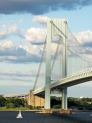
Staten Island is the southernmost borough of New York City, coextensive with Richmond County and situated at the southern tip of the U.S. state of New York. The borough is separated from the adjacent state of New Jersey by the Arthur Kill and the Kill Van Kull and from the rest of New York by New York Bay. With a population of 495,747 in the 2020 Census, Staten Island is the least populated New York City borough but the third largest in land area at 58.5 sq mi (152 km2); it is also the least densely populated and most suburban borough in the city.

The Staten Island Railway (SIR) is a rapid transit line in the New York City borough of Staten Island. It is owned by the Staten Island Rapid Transit Operating Authority (SIRTOA), a subsidiary of the Metropolitan Transportation Authority, and operated by the New York City Transit Authority Department of Subways. SIR operates 24 hours a day, seven days a week, providing local service between St. George and Tottenville, along the east side of the island. There is currently only one line on the island, and there is no direct rail link between the SIR and the New York City Subway system, but SIR riders do receive a free transfer to New York City Transit bus and subway lines, and the line is included on official New York City Subway maps. Commuters on the railway typically use the Staten Island Ferry to reach Manhattan. The line is accessible from within the Ferry Terminal, and most of its trains are timed to connect with the ferry. In 2022, the system had a ridership of 3,757,700, or about 13,000 per weekday as of the third quarter of 2023.

Tottenville is a neighborhood on the South Shore of Staten Island, New York City. It is the southernmost neighborhood and settlement in both New York City and New York State, as well as the westernmost neighborhood in New York City. Tottenville is bounded on three sides by water: the south side abuts the New York Bight while the west and north sides are bordered by the Arthur Kill. Nassau Place, Bethel Avenue and Page Avenue form the neighborhood's eastern border.
St. George is a neighborhood on the northeastern tip of Staten Island in New York City, along the waterfront where the Kill Van Kull enters Upper New York Bay. It is the most densely developed neighborhood on Staten Island, and the location of the administrative center for the borough and for the coterminous Richmond County. The St. George Terminal, serving the Staten Island Ferry and the Staten Island Railway, is also located here. St. George is bordered on the south by the neighborhood of Tompkinsville and on the west by the neighborhood of New Brighton.

Stapleton is a neighborhood in northeastern Staten Island in New York City, United States. It is located along the waterfront of Upper New York Bay, roughly bounded on the north by Tompkinsville at Grant Street, on the south by Clifton at Vanderbilt Avenue, and on the west by St. Paul's Avenue and Van Duzer Street, which form the border with the community of Grymes Hill.

New Brighton is a neighborhood located on the North Shore of Staten Island in New York City. The neighborhood comprises an older industrial and residential harbor front area along the Kill Van Kull west of St. George. New Brighton is bounded by Kill Van Kull on the north, Jersey Street on the east, Brighton and Castleton Avenues to the south, and Lafayette Avenue and Snug Harbor Cultural Center to the west. It is adjacent to St. George to the east, Tompkinsville to the south, and West New Brighton to the west.

Charleston is a neighborhood, or section, of New York City's borough of Staten Island. It is located on the island's South Shore, with Tottenville to the south, Pleasant Plains to the East, Rossville to the north, and the Arthur Kill to the west. The neighborhood is represented in the New York City Council by Joe Borelli and in the New York State Senate by Andrew Lanza.

Great Kills is a neighborhood within the borough of Staten Island in New York City. It is located on the island's South Shore, and according to many local geographers, it is the South Shore's northernmost community. It is bordered by Richmondtown to the north, Bay Terrace to the east, Eltingville to the west, and Great Kills Harbor to the south.

Annadale is a middle-class neighborhood on the South Shore of the borough of Staten Island in New York City.

Rosebank is a neighborhood in northeastern Staten Island, one of New York City's five boroughs. It borders Clifton to the north, Arrochar to the south, and the Upper New York Bay to the east.
Arden Heights is a name increasingly applied to the western part of Annadale, a neighborhood located on the South Shore of Staten Island, New York City, USA. The name "Arden Heights" is found on most maps of New York City, including Hagstrom's.
Grymes Hill is a 374 feet (114 m) tall hill formed of serpentine rock on Staten Island, New York. It is the second highest natural point on the island and in the five boroughs of New York City. The neighborhood of the same name encompasses an area of 0.894 square miles (2.32 km2) and has a population of 8,263 people. The hill also includes parts of the Silver Lake neighborhood. The area includes part of ZIP Codes 10301 and 10304.
The New York City Farm Colony was a poorhouse on the New York City borough of Staten Island, one of the city's five boroughs. It was located across Brielle Avenue from Seaview Hospital, on the edge of the Staten Island Greenbelt.
Staten Island light rail proposals refer to two projects in the New York City borough of Staten Island. These proposals are among the several light rail projects that have been floated in New York City in recent years. Neither proposal was funded in the Metropolitan Transportation Authority's 2015–2019 Capital Plan, but $4 million was allocated to a study for it.
Susan E. Wagner High School is a New York City public school located at 1200 Manor Road in Staten Island, New York. The school is owned and run by the New York City Department of Education. It opened in September 1968, and was named in honor of Susan E. Wagner (1909–1964), the late wife of former mayor Robert F. Wagner Jr. On average, the school has about 3,300 students. Wagner's school colors are Navy and White, with the Falcon as the mascot. Wagner has a variety of programs including the Law and Politics program, the Virtual Enterprise program, the Scholars Academy, Air Force JROTC, Theatrical Arts program, and annual SING! productions. The school has the largest marching band in New York City, with over 150 members. The school received the Blue Ribbon School of Excellence in the 1988–1989 school year.
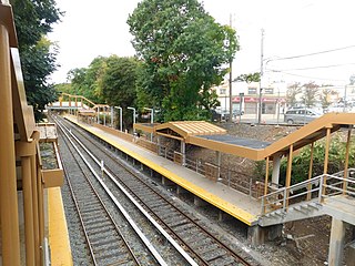
The Annadale station is a Staten Island Railway station in the neighborhood of Annadale, Staten Island, New York.
David John J. Carnivale is an architect, preservationist, author, and artist. He wrote The Affordable House, which was the second book to appear cover-to-cover on the internet, featured on the web's first architectural website The Affordable House. Since 2005 it has been published by BookSurge.com.

St. George Coast Guard Station, or the Staten Island Coast Guard Station, located adjacent to the Staten Island Ferry St. George Terminal, is a complex of 22 historic buildings and was best known for the invention and manufacturing of lighthouse equipment. The Office Building and U.S. Light-House Depot Complex, designed by Alfred B. Mullet and completed in 1865, are listed on the National Register of Historic Places, and comprise an official New York City Landmark.

The Staten Island Railway (SIR) is the only rapid transit line in the New York City borough of Staten Island and is operated by the Staten Island Rapid Transit Operating Authority, a unit of the Metropolitan Transportation Authority. The railway was historically considered a standard railroad line, but today only the western portion of the North Shore Branch, which is disconnected from the rest of the SIR, is used by freight and is connected to the national railway system.
References
- O'Shea, Karen (October 4, 2006). "$40M Pricetag for Historic S. Shore Site Former Spanish Camp, the Focus of Controversy, Being Marketed As 'Rare' Development Opportunity". Staten Island Advance . p. 1. Retrieved March 6, 2023– via Historic Districts Council.
