Akron is the fifth-largest city in the U.S. state of Ohio and is the county seat of Summit County. It is located on the western edge of the Glaciated Allegheny Plateau, about 40 miles (64 km) south of downtown Cleveland. As of the 2019 Census estimate, the city proper had a total population of 197,597, making it the 125th largest city in the United States. The Greater Akron area, covering Summit and Portage counties, had an estimated population of 703,505.

The Wabash and Erie Canal was a shipping canal that linked the Great Lakes to the Ohio River via an artificial waterway. The canal provided traders with access from the Great Lakes all the way to the Gulf of Mexico. Over 460 miles long, it was the longest canal ever built in North America.

Cuyahoga Valley National Park is an American national park that preserves and reclaims the rural landscape along the Cuyahoga River between Akron and Cleveland in Northeast Ohio.
The Miami and Erie Canal was a 274-mile (441 km) canal that ran from Cincinnati to Toledo, Ohio, creating a water route between the Ohio River and Lake Erie. Construction on the canal began in 1825 and was completed in 1845 at a cost to the state government of $8,062,680.07. At its peak, it included 19 aqueducts, three guard locks, 103 canal locks, multiple feeder canals, and a few man-made water reservoirs. The canal climbed 395 feet (120 m) above Lake Erie and 513 feet (156 m) above the Ohio River to reach a topographical peak called the Loramie Summit, which extended 19 miles (31 km) between New Bremen, Ohio to lock 1-S in Lockington, north of Piqua, Ohio. Boats up to 80 feet long were towed along the canal by mules, horses, and oxen walking on a prepared towpath along the bank, at a rate of four to five miles per hour.

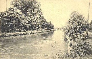
The Ohio and Erie Canal was a canal constructed during the 1820s and early 1830s in Ohio. It connected Akron with the Cuyahoga River near its outlet on Lake Erie in Cleveland, and a few years later, with the Ohio River near Portsmouth. It also had connections to other canal systems in Pennsylvania.
Summit Metro Parks is a Metroparks system serving the citizens of Summit County, Ohio by managing 14,000 acres (5,700 ha) in 16 developed parks, six conservation areas and more than 150 miles (240 km) of trails, with 22.4 miles (36.0 km) of the Ohio & Erie Canal Towpath Trail.

This is a list of properties and districts in Ohio that are listed on the National Register of Historic Places. There are over 4.000 in total. Of these, 73 are National Historic Landmarks. There are listings in each of Ohio's 88 counties.

The Pennsylvania and Ohio Canal, also known as the P & O Canal, the Cross Cut Canal and the Mahoning Canal was a shipping canal which operated from 1840 until 1877. It was unique in that it served to connect canals in two states and was funded by private interests.
The Jaite Mill Historic District, also known as Jaite, is a nationally recognized historic district in Cuyahoga and Summit counties in the U.S. state of Ohio. The Cuyahoga County portion of the district is located in the city of Brecksville, while the Summit County portion is located in Sagamore Hills Township. Built in 1903 as the Jaite Company Paper Mill, its center is at the intersection of Vaughn and Riverview roads, north of the crossing of Interstates 80 and 271.

Tinkers Creek Aqueduct is an aqueduct that was constructed to bridge the Ohio and Erie Canal over Tinkers Creek near its confluence with the Cuyahoga River in Valley View, Ohio. It is a relatively rare surviving example of an Ohio and Erie Canal aqueduct. It was originally constructed in 1825-1827 by, and re-built due to flood damage in 1845 and 1905. Tinkers Creek Aqueduct was included in a National Historic Landmark district established in 1966, and it was separately listed on the National Register of Historic Places in 1979. The original Tinkers Creek Aqueduct was a wood plank, steel truss, and Ashlar-sandstone structure constructed in 1827, south of the present aqueduct's location. Cuyahoga River and Tinkers Creek flooding caused continual damage to the original aqueduct, so successive structures were built in 1845 and 1905 in the present location. Today, Tinkers Creek Aqueduct is the only aqueduct which remains of the four original aqueducts in the Cuyahoga Valley. Of Furnace Run Aqueduct, Mill Creek Aqueduct, Peninsula Aqueduct, and Aqueduct; Mill Creek Aqueduct, of newer construction, is the only aqueduct which still carries Ohio and Erie Canal water. After 102 years of flooding, weathering, and deterioration, Tinkers Creek Aqueduct was removed in 2007. The National Park Service is currently working on Phase II of the project to reconstruct it from newer materials.

The Akron, Ohio, metropolitan statistical area, as defined by the United States Office of Management and Budget, is an area consisting of two counties, Summit and Portage, in Northeast Ohio and is anchored by the city of Akron. As of the 2010 census, the MSA had a population of 703,200.

The Kent Industrial District is a historic district in Kent, Ohio, United States, listed on the National Register of Historic Places. The district covers around 4.3 acres (1.7 ha) of downtown Kent on either side of the Cuyahoga River and is roughly bounded by West Main Street on the north, River Street to the west, Franklin Avenue to the east and Haymaker Parkway to the south. Within the district are three buildings and two stone structures of historical significance. It was listed on the National Register of Historic Places in 1974. Kent namesake Marvin Kent was involved in several aspects of the district's development and the area would play a key role in the development of Kent during much of the 19th century. The earliest structures in the district date to the 1830s with the most recent historic structure, the livery and carriage shop building, dating to 1910. The area today is occupied mostly by the city of Kent's Franklin Mills Riveredge Park, Heritage Park, and various private landowners.
The Summit County Historical Society of Akron, Ohio, abbreviated SCHS, is a 501(c)(3) non-profit organization located in Akron, Ohio. It focuses on the history of the City of Akron and Summit County, Ohio.
Everett Historic District is a rural village located within Cuyahoga Valley National Park. It is registered on the National Register of Historic Places. Everett is unique for being uncompromised by the pressures of suburban development. It represents a typical unincorporated hamlet of the turn of the 20th century rural America.

The Boston Mills Historic District is a historic district in the Cuyahoga Valley National Park in Northeast Ohio in the United States. With the opening of the Ohio and Erie Canal in 1827, people began to settle in this vicinity. By 1842, there was a water-powered mill, a large warehouse, a boat-yard, two stores and a hotel, and the population was around 300. A number of houses and other buildings dating back to that period remain.
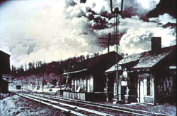
The Valley Railway Historic District is a historic district partially located in the Cuyahoga Valley National Park, extending from Independence to Akron, Ohio. It was added to the National Register of Historic Places in 1985.

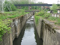
The Lockington Locks are a group of canal locks on the former Miami and Erie Canal in Lockington, Ohio, United States. Built beginning in 1833, the locks opened for regular use in 1845. The system consists of seven locks: six together at one end, and a seventh at the southern end. Along with features such as basins to allow canal boats to turn around, the locks stretch for 3.75 miles (6.04 km) between Lockington in far southern Shelby County and Washington Township in far northern Miami County.
This is a list of the National Register of Historic Places listings in Cuyahoga Valley National Park.

Cascade Plaza is an open space with plantings and pedestrian walkways in Akron, Ohio. It was developed in the late 1960s as part of an urban renewal project that also included construction of two high rises. As of 2013 plans were going forward for a major overhaul.

The Valley Railway was a shortline railroad which operated between the city of Cleveland and small town of Zoarville in the state of Ohio in the United States. The railroad was founded in 1871, but the first segment of track did not open until 1880 and the line was not completed until 1884. The Baltimore and Ohio Railroad (B&O) obtained a controlling interest in the Valley Railway in 1890. The railroad went bankrupt in 1895, at which time it was reorganized as the Cleveland, Terminal and Valley Railway (CT&V). The B&O took over operation of the CT&V in 1909, and the company was merged with the B&O in 1915.