
The 1962 Atlantic hurricane season featured Hurricanes Daisy and Ella – two tropical cyclones that showed the latest dates for the fourth and fifth named storms on record since tropical cyclones were first named in the North Atlantic ocean, starting in 1950, when they both formed on September 29 and October 14. On the same hand, it was the least active since 1939, with only five named storms. Although the season officially began on June 15, the first named storm did not form until August 26, the third-latest date. Hurricane Alma brushed the Outer Banks before becoming extratropical southeast of New England, destroying hundreds of boats and producing beneficial rainfall. In late August, Tropical Storm Becky developed unusually far east in the Atlantic Ocean, becoming the easternmost storm on record to recurve to the northeast. Celia followed in the September, forming east of the Lesser Antilles and executing a loop near Bermuda before dissipating. Hurricane Daisy, the latest fourth named storm, was the costliest of the season, leaving about $1.1 million in damage in New England (1962 USD). The storm dropped the highest rainfall total on record in Maine, and its precipitation caused 22 traffic fatalities. The final hurricane – Ella – the latest fifth named storm – was also the strongest, remaining offshore of the eastern United States but causing two deaths.

The 1936 Atlantic hurricane season was a fairly active season, with 20 tropical cyclones recorded, 17 of which became tropical storms. Seven storms became hurricanes, of which one became a major hurricane. In addition, the season was unusual in the fact that no storms moved across large portions of the Caribbean Sea. Seven storms, including three hurricanes, struck the United States.

The 1925 Atlantic hurricane season was a below-average Atlantic hurricane season during which four tropical cyclones formed. Only one of them was a hurricane. The first storm developed on August 18, and the last dissipated on December 1. The season began at a late date, more than two months after the season began. The official start of the season is generally considered to be June 1 with the end being October 31; however, the final storm of the season formed nearly a month after the official end. Due to increased activity over the following decades, the official end of the hurricane season was shifted to November 30.

The 1919 Atlantic hurricane season was among the least active hurricane seasons in the Atlantic on record, featuring only five tropical storms. Of those five tropical cyclones, two of them intensified into a hurricane, with one strengthening into a major hurricane Two tropical depressions developed in the month of June, both of which caused negligible damage. A tropical storm in July brought minor damage to Pensacola, Florida, but devastated a fleet of ships. Another two tropical depressions formed in August, the first of which brought rainfall to the Lesser Antilles.

The 1905 Atlantic hurricane season featured five known tropical cyclones, two of which made landfall in the United States. The first system was initially observed near the Windward Islands on September 6. The last system to dissipate, the fourth storm, transitioned into an extratropical cyclone on October 11, while located well southeast of Newfoundland. These dates fall within the period with the most tropical cyclone activity in the Atlantic. Between October 5 and October 10, the fourth and fifth system existed simultaneously.

The 1903 Atlantic hurricane season featured seven hurricanes, the most in an Atlantic hurricane season since 1893. The first tropical cyclone was initially observed in the western Atlantic Ocean near Puerto Rico on July 21. The tenth and final system transitioned into an extratropical cyclone well northwest of the Azores on November 25. These dates fall within the period with the most tropical cyclone activity in the Atlantic. Six of the ten tropical cyclones existed simultaneously.

The 1901 Atlantic hurricane season was the most active season without a major hurricane – tropical cyclones that reach at least Category 3 on the Saffir–Simpson hurricane wind scale – until 2013. The first system was initially observed in the northeastern Caribbean on June 11. The fourteenth and final system transitioned into an extratropical cyclone near Bermuda on November 5. These dates fall within the period with the most tropical cyclone activity in the Atlantic. Eight of the fourteen tropical cyclones existed simultaneously.

The 1899 Atlantic hurricane season featured the longest-lasting tropical cyclone in the Atlantic basin on record. There were nine tropical storms, of which five became hurricanes. Two of those strengthened into major hurricanes, which are Category 3 or higher on the modern day Saffir–Simpson hurricane wind scale. The first system was initially observed in the northeastern Gulf of Mexico on June 26. The tenth and final system dissipated near Bermuda on November 10. These dates fall within the period with the most tropical cyclone activity in the Atlantic. In post-season analysis, two tropical cyclones that existed in October were added to HURDAT – the official Atlantic hurricane database. At one point during the season, September 3 through the following day, a set of three tropical cyclones existed simultaneously.

The 1897 Atlantic hurricane season was an inactive season, featuring only six known tropical cyclones, four of which made landfall. There were three hurricanes, none of which strengthened into major hurricanes, which are Category 3 or higher on the modern-day Saffir–Simpson hurricane wind scale. The first system was initially observed south of Cape Verde on August 31, an unusually late date. The storm was the strongest of the season, peaking as a Category 2 hurricane with winds of 100 mph (155 km/h). While located well north of the Azores, rough seas by the storm sunk a ship, killing all 45 crewmen. A second storm was first spotted in the Straits of Florida on September 10. It strengthened into a hurricane and tracked northwestward across the Gulf of Mexico, striking Louisiana shortly before dissipating on September 13. This storm caused 29 deaths and $150,000 (1897 USD) in damage.

The Gale of 1878, was an intense Category 2 hurricane that was active between October 18 and October 25. It caused extensive damage from Cuba to New England. Believed to be the strongest storm to hit the Washington - Baltimore region since hurricane records began in 1851, a complete record exists of this hurricane throughout its lifecycle from formation to dissipation.

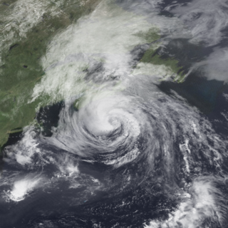
Hurricane Esther was the first large tropical cyclone to be discovered by satellite imagery. The fifth tropical cyclone, named storm, and hurricane of the 1961 Atlantic hurricane season, Esther developed from an area of disturbed weather hundreds of miles west-southwest of the southernmost Cape Verde Islands on September 10. Moving northwestward, the depression strengthened into Tropical Storm Esther on September 11, before reaching hurricane intensity on the following day. Early on September 13, Esther curved westward and deepened into a major hurricane. The storm remained a Category 3 hurricane for about four days and gradually moved in a west-northwestward direction. Late on September 17, Esther strengthened into a Category 5 hurricane with sustained winds of 160 mph (260 km/h) on September 18. The storm curved north-northeastward on September 19, while offshore of North Carolina. Esther began to weaken while approaching New England and fell to Category 3 intensity on September 21. The storm turned eastward early on the following day, and rapidly weakened to a tropical storm.

Hurricane Charley was the second hurricane to threaten the East Coast of the United States within a year's timeframe, after Hurricane Gloria of 1985. The third tropical storm and second hurricane of the season, Charley formed as a subtropical low on August 13 along the Florida panhandle. After moving off the coast of South Carolina, the system transitioned into a tropical cyclone and intensified into a tropical storm on August 15. Charley later attained hurricane status before moving across eastern North Carolina. It gradually weakened over the north Atlantic Ocean before transitioning into an extratropical cyclone on August 20. Charley's remnants remained identifiable for over a week, until after crossing Ireland and Great Britain they dissipated on August 30.

The 1933 Chesapeake–Potomac hurricane was among the most damaging hurricanes in the Mid-Atlantic states in the eastern United States. The sixth storm and third hurricane of the very active 1933 Atlantic hurricane season, it formed in the eastern Atlantic, where it moved west-northwestward and eventually became a Category 4 on the Saffir-Simpson hurricane wind scale. A strong ridge over New England allowed a continued northwest course, bringing the storm south of Bermuda and later toward the middle coast of the eastern United States. Advanced warning allowed hundreds of people to evacuate ahead of the hurricane making landfall. It did so in northeastern North Carolina on August 23 with winds of about 90 mph (140 km/h). Soon after, the eye crossed over Norfolk, Virginia, the first time that happened since 1821. The hurricane weakened into a tropical storm over northern Virginia shortly before passing near Washington, D.C., becoming the worst tropical cyclone there since 1896. Curving northward, the storm moved through Pennsylvania and New York before losing tropical characteristics on August 25. Now extratropical, the former hurricane moved across Atlantic Canada, dissipating on August 28.

The 1933 Outer Banks hurricane lashed portions of the North Carolina and Virginia coasts less than a month after another hurricane hit the general area. The twelfth tropical storm and sixth hurricane of the 1933 Atlantic hurricane season, it formed by September 8 to the east of the Lesser Antilles. It moved generally to the north-northwest and strengthened quickly to peak winds of 140 mph (230 km/h) on September 12. This made it a major hurricane and a Category 4 on the Saffir-Simpson scale. The hurricane remained at or near that intensity for several days while tracking to the northwest. It weakened approaching the southeastern United States, and on September 16 passed just east of Cape Hatteras, North Carolina with winds of about 100 mph (160 km/h). Turning to the northeast, the hurricane became extratropical on September 18 before moving across Atlantic Canada, eventually dissipating four days later.
Hurricane Bertha caused minor damage in the United States, Bermuda, and Atlantic Canada in July and August 1990. The third tropical cyclone, second named storm, and first hurricane of the 1990 Atlantic hurricane season, Bertha developed from a frontal low pressure area offshore of North Carolina on July 24. Initially subtropical, it slowly acquired tropical characteristics while tracked southeast and then southwestward. By early on July 27, the cyclone was re-classified as a tropical depression. Following its transition, the depression intensified and was upgraded to Tropical Storm Bertha on July 28. The storm then curved northeastward and rapidly strengthened. Bertha became a hurricane early on July 29, though it weakened back to a tropical storm later that day. On the following day, Bertha re-intensified into a hurricane and peaked as an 80 mph (130 km/h) Category 1 hurricane on July 31.

The 1903 New Jersey hurricane, also known as the Vagabond Hurricane by The Press of Atlantic City, is the first and only known North Atlantic hurricane to make landfall in the state of New Jersey since records were kept starting in 1851. The fourth hurricane of the season, the cyclone was first observed on September 12 about 550 miles northeast of Antigua. It moved quickly westward, then later turned to the north-northwest, steadily strengthening to reach a peak intensity of 100 miles per hour, a Category 2 on the modern-day Saffir–Simpson scale. The hurricane weakened slightly before striking near Atlantic City, New Jersey, on September 16 with winds of 80 mph (130 km/h). It weakened over Pennsylvania and became an extratropical cyclone over western New York on September 17.

The 1924 Atlantic hurricane season featured the first officially recorded Category 5 hurricane, a tropical cyclone with maximum sustained winds exceeding 155 mph (249 km/h) on the modern-day Saffir–Simpson scale. The first system, Tropical Storm One, was first detected in the northwestern Caribbean Sea on June 18. The final system, an unnumbered tropical depression, dissipated on November 24. These dates fall within the period with the most tropical cyclone activity in the Atlantic. Of the 13 tropical cyclones of the season, six existed simultaneously. The season was average with 11 tropical storms, five of which strengthened into hurricanes. Further, two of those five intensified into major hurricanes, which are Category 3 or higher on the Saffir–Simpson scale.

Hurricane How was the only tropical cyclone to make landfall on the United States in 1951. It was the eighth storm of the season, forming on September 28 in the northwest Caribbean and, after entering the Gulf of Mexico, turned eastward and became a tropical storm. The storm brought heavy rainfall to Florida, causing flooding and $2 million in damage. Tropical Storm How later became a hurricane, passing near the Outer Banks of North Carolina where it produced strong winds and high tides. A ship called the "Southern Isles" capsized off Cape Hatteras, killing 17 out of the crew of 23. Rains and high tides occurred in southeastern New England, before the hurricane moved out to sea and became extratropical.

The 1940 New England hurricane moved off of the U.S. East Coast and Atlantic Canada in August and September 1940, producing strong winds and torrential rainfall. The fourth tropical cyclone and third hurricane of the season, the storm originated from a well-defined low-pressure area in the open Atlantic Ocean on August 26. Moving slowly in a general west-northwest motion, the disturbance intensified, reaching tropical storm strength on August 28 and subsequently hurricane intensity on August 30. The hurricane passed within 85 mi (137 km) of Cape Hatteras before recurving towards the northeast. The hurricane continued to intensify, and reached peak intensity as a Category 2 hurricane with maximum sustained winds of 110 mph (180 km/h) and a minimum barometric pressure of 961 mbar, though these statistical peaks were achieved at different times on September 2. Afterwards, the hurricane began a weakening trend as it proceeded northeastward, and had degenerated into a tropical storm by the time it made its first landfall on Nova Scotia later that day. The storm transitioned into an extratropical cyclone the next day while making another landfall on New Brunswick. The extratropical remnants persisted into Quebec before merging with a larger extratropical system late on September 3.

The 1896 East Coast hurricane was a slow-moving tropical cyclone that battered the East Coast of the United States from Florida to New England in mid-October 1896. The fifth tropical cyclone of the 1896 Atlantic hurricane season, it formed on October 7 in the southern Gulf of Mexico, and caused minor damage in Florida while crossing the state two days later. From October 10 through 13, the hurricane drifted northeastward along the coast, reaching its peak intensity as the equivalence of a Category 2 hurricane on the modern-day Saffir–Simpson scale. The hurricane subjected many areas along the East Coast to days of high seas and damaging northeasterly winds, which halted shipping operations.
