2017–2019 eruptions of Mount Agung

Last updated

2017–2019 eruptions of Mount Agung
Mount Agung, November 2017 eruption - 27 Nov 2017 02.jpg
Mount Agung on 27 November 2017
Volcano Mount Agung
Start date21 November 2017 (2017-11-21) [1]
End date12 June 2019 (2019-06-12) [1]
Type Vulcanian/Sub-plinian
Location Bali, Indonesia
8°20′35″S115°30′25″E / 8.34306°S 115.50694°E / -8.34306; 115.50694
VEI 3 [1]
Indonesia Bali location map.svg
Vulcano-fire-icon.svg
Mount Agung
Location of Mount Agung, Bali

Mount Agung, a volcano on the island of Bali in Indonesia, erupted five times in late November 2017, causing thousands to evacuate, disrupting air travel and causing environmental damage. As of 27 November 2017, the alert level was at its highest and evacuation orders were in place.

Contents

Tectonic earthquakes from the volcano had been detected since early August 2017, and volcanic activity intensified for several weeks before decreasing significantly in late October. A second, more violent period of major activity began in late November. Agung has since had eruptions in January, June, July and December 2018 and January, February, March, April, May and June 2019.

Background

1843 eruption

Agung erupted in 1843 [2] as reported by Heinrich Zollinger:

After having been dormant for a long time, this year the mountain began to be alive again. In the first days of the activity, earthquake shocks were felt followed by the emission of ash, sand and stones. [3]

1963 eruption

Mount Agung's 1963 eruption was among the most catastrophic volcanic events in Indonesian history. After initial explosions in the crater on 18 February of that year, lava began flowing down the mountain on 24 February, eventually travelling 7 kilometres (4.3 mi) over the next three weeks. On 17 March, a highly explosive eruption occurred, reaching a VEI (Volcanic Explosivity Index) of 5 and sending lethal pyroclastic flows at high speeds down the mountain's slopes, killing at least 1,500 people. [4] Heavy rainfall mixed with ash from the eruption in the following days caused extensive lahars which killed about 200 more people. A smaller eruption occurred on 16 May, sending pyroclastic flows down the mountain once more, killing about 200 more people. [4] [5] By the time the eruptions ceased in early 1964, they had claimed about 1,900 lives, marking the event as the 8th deadliest volcanic eruption of the 20th century.

Since 1963, the population of Bali has nearly doubled. [6] Mount Agung is therefore considered highly dangerous by Indonesian authorities. This concern was the primary reason behind their decision to evacuate more than 100,000 people in response to the surge in local tectonic activity in the latter half of 2017. [5]

Major activity in 2017

August

Volcanic earthquakes were observed from 10 August 2017 [7] and the intensity increased in the following weeks.

September

On 30 September 2017, an increase of rumbling and seismic activity around the volcano made people raise the alert to the highest level and about 122,500 people were evacuated from their homes around the volcano. [8] The Indonesian National Disaster Management Authority declared a 12-kilometre (7.5 mi) exclusion zone around the volcano on 24 September. [9] A plume was observed on 13 September. [7]

Evacuees gathered in sports halls and other community buildings around Klungkung, Karangasem, Buleleng, and other areas. [10] The monitoring station is in Tembuku, Rendang, Karangasem Regency, where intensity and frequency of tremors were monitored for signs of the imminent large eruption. [11]

The area experienced 844 volcanic earthquakes on 25 September, and 300 to 400 earthquakes by midday on 26 September. Seismologists have been alarmed at the force and frequency of the incidents as it has taken much less for similar volcanoes to erupt. [12] [13]

October

In late October 2017, the activity of the volcano decreased significantly, leading to lowering of the alert status on 29 October. [14]

The alert level remained at 3 (out of 4) until the start of the second major activity period, and plumes were observed during this time. [15] [16]

November

21 November

A small phreatic eruption was reported at 09:05 on 21 November (UTC), with the top of the ash cloud reaching 3,842 metres (12,605 ft) above sea level. [17] Thousands of people immediately fled the area, [18] and over 29,000 temporary refugees were housed in over 270 locations nearby. [19]

25 November

Ash plume from Mount Agung on 27 November 2017 Mount Agung, November 2017 eruption - 27 Nov 2017 01.jpg
Ash plume from Mount Agung on 27 November 2017

A magmatic eruption began early on Saturday morning, 25 November. [20] The eruption plume rose 1.5–4 kilometres (4,900–13,100 ft; 1,500–4,000 m) above the summit crater, drifting towards the south [20] and dusting the surroundings with a thin layer of dark ash, leading some airlines to cancel flights bound for Australia [20] and New Zealand. An orange glow was later observed around the crater at night, confirming that fresh magma had reached the surface. [21] [22]

26 November

Map sulfur dioxide (SO2) distribution by NASA's Aura satellite after eruption, 27 November 2017 SO2 concentration after Mount Agung eruption.png
Map sulfur dioxide (SO2) distribution by NASA's Aura satellite after eruption, 27 November 2017

At 23:37 on 26 November (UTC), another eruption occurred. Ngurah Rai International Airport was closed next day, [23] leaving many tourists stranded. [24] More than 100,000 people in a 10-kilometre (6.2 mi) radius of the volcano were ordered to evacuate. [25]

27 November

NASA MODIS aerial view of ash from Terra satellite, 29 November 2017 NASA MODIS aerial view of Agung ash 2017.jpg
NASA MODIS aerial view of ash from Terra satellite, 29 November 2017

Sunday 26 November's eruption continued at a constant rate, [26] and lahars were reported in the Selat district south of the volcano. [24] The Australian Government's Bureau of Meteorology reported that the top of the eruption column had reached an altitude of 9,144 metres (30,000 ft). [27] Ash continued to spread in a southeasterly direction, and estimates by the Pacific Disaster Center predicted that the resulting atmospheric ash exposure would affect up to 5.6 million people within the densely populated region surrounding the volcano. [26]

29 November

Reductions in eruption intensity and wind dispersal of the ash cloud led authorities to reopen Ngurah Rai International Airport at 07:00 (UTC). [28] [29] Authorities also warned that the eruption volume could increase again at any time, potentially shutting down air traffic once more. [29]

Activity in 2018

January

The volcano erupted once again on 11 January, sending plumes of smoke and ash, while Indonesia's Bali international airport was declared safe, operating normally. [30] The eruption column was reported to rise `2.5 kilometres (8,200 ft; 2,500 m) above the mountain.

June

Agung erupted on 12 June, sending plumes of smoke and ash some 2,000 metres (6,600 ft) above the volcano's summit. [31] No flights were affected from the event.

On 28 June, water vapour and volcanic ash emission were detected from Mount Agung up to two kilometres (6,600 ft; 2,000 m) into the air. The Ngurah Rai Airport was closed due to the event. [32] [33]

July

Agung erupted again 3 July due to a minor strombolian explosion. 700 people living near the crater were evacuated. No flights were affected. [34]

December

On the morning of 30 December, the volcano sent ash skywards as it erupted for about three minutes, spewing white clouds of smoke and ash more than 700 metres (2,300 ft) into the air. [35] Several villages in Bali were covered in a thin layer of ash, but no smoke or lava was detected coming from the volcano and no evacuation has been ordered. [35]

Major activity in 2019

January

Agung erupted on 10 January, producing columns of volcanic ash. The summit of the volcano was covered by thick haze during eruption and thus the height of the ash could not be seen. [36]

February

On 22 February, volcanic ash plume that rose up to estimated 14,000 feet (4,300 m) altitude or flight level 140

March

Explosive activity continues on 8 March or the day after Nyepi, with a volcanic ash plume that rose up to estimated 12,000 feet (3,700 m) altitude or flight level 120 and is moving at 10 knots (19 km/h; 12 mph) in south east direction. [37]

Mt. Agung erupted again on 28 March. [38] Bali's I Gusti Ngurah Rai International Airport operated normally despite the eruption, as the airspace above the airport was declared clear of volcanic ash based on a paper test.

April

A 2,000-metre-high (6,600 ft) high column of ash erupted out of Agung on 3 April 2019. [39] The Center for Volcanology and Geological Hazard Mitigation (PVMBG) maintained the volcano's alert level at "stay on alert", the third level of the four-tiered alert system. The center also set the danger zone at a 4-kilometre (2.5 mi) radius from the crater.

May

In late May 2019 an eruption spewed lava and rocks over about 3 kilometres (9,800 ft; 3,000 m), with some ash fall on nearby villages and temporarily interrupting international flights. [40]

June

Another explosion occurred at the volcano at 13 June 2019, 01:38 local time. A Vulcanian eruption ejected much incandescent material to distances of at least 700 metres (2,300 ft) from the crater and generated an ash plume that rose to 30,000 feet (9,100 m) altitude and drifting south over Denpasar.

According to PVMBG, the eruption lasted almost 10 minutes, marking it one of the longest in the recent series of such Vulcanian explosions. A small earthquake swarm and slight inflation on 12 June 2019 preceded the eruption. [41] [42]

Impact

The 2017 eruption caused some 40,000 people to be evacuated from 22 villages around Mount Agung. It also caused surrounding airports to be closed. Lombok International Airport, on the neighboring island of Lombok, closed on 26 November, but was reopened the next morning, [43] only to be closed again on 30 November. [44] Lombok's airport reopened on 1 December. Ngurah Rai International Airport, located at the southern tip of the island and southwest of the volcano, closed on 27 November. [45] More than 400 flights were canceled and about 59,000 passengers remained grounded. [46] The airport was reopened on 29 November. This eruption also caused a decline in tourism on Bali by about 30%.

Related Research Articles

<span class="mw-page-title-main">Klyuchevskaya Sopka</span> Volcano on the Kamchatka peninsula, Russia

Klyuchevskaya Sopka is a stratovolcano, the highest mountain of Siberia and the highest active volcano of Eurasia. Its steep, symmetrical cone towers about 100 kilometres (60 mi) from the Bering Sea. The volcano is part of the natural Volcanoes of Kamchatka UNESCO World Heritage Site. Klyuchevskaya Sopka is ranked 15th by topographic isolation.

<span class="mw-page-title-main">Popocatépetl</span> Stratovolcano in Puebla, Mexico

Popocatépetl is an active stratovolcano located in the states of Puebla, Morelos, and Mexico in central Mexico. It lies in the eastern half of the Trans-Mexican volcanic belt. At 5,393 m (17,694 ft) it is the second highest peak in Mexico, after Citlaltépetl at 5,636 m (18,491 ft).

<span class="mw-page-title-main">Mayon</span> Stratovolcano in the Philippines

Mayon, also known as Mount Mayon and Mayon Volcano, is an active stratovolcano in the province of Albay in Bicol, Philippines. A popular tourist spot, it is renowned for its "perfect cone" because of its symmetric conical shape, and is regarded as sacred in Philippine mythology.

<span class="mw-page-title-main">Mount Bromo</span> Somma volcano in Indonesia

The Bromo, or Mount Bromo is an active somma volcano and part of the Tengger mountains, in East Java, Indonesia. At 2,329 meters (7,641 ft) it is not the highest peak of the massif, but is the most active and famous. The area is one of the most visited tourist destinations in East Java, and the volcano is included in the Bromo Tengger Semeru National Park. The name Bromo comes from the Javanese pronunciation of Brahma, the Hindu god of creation. At the mouth of the crater, there is an idol of Ganesha, the Hindu god of wisdom which is being worshipped by the Javanese Hindus. Mount Bromo is located in the middle of a plain called "Sea of Sand", a nature reserve that has been protected since 1919.

<span class="mw-page-title-main">Sakurajima</span> Stratovolcano in Kagoshima Prefecture, Kyushu, Japan

Sakurajima is an active stratovolcano, formerly an island and now a peninsula, in Kagoshima Prefecture in Kyushu, Japan. The lava flows of the 1914 eruption connected it with the Ōsumi Peninsula. It is the most active volcano in Japan.

<span class="mw-page-title-main">Bezymianny</span> Stratovolcano on the Kamchatka peninsula, Russia

Bezymianny is an active stratovolcano in Kamchatka, Russia. Bezymianny volcano had been considered extinct until 1955. Activity started in 1955, culminating in a dramatic eruption on 30 March 1956. This eruption, similar to that of Mount St. Helens in 1980, produced a large horseshoe-shaped crater that was formed by collapse of the summit and an associated lateral blast. Subsequent episodic but ongoing lava dome growth, accompanied by intermittent explosive activity and pyroclastic flows, has largely filled the 1956 crater. The most recent eruption of lava flows occurred in February 2013. An explosive eruption on 20 December 2017 released an ash plume rising to a height of 15 kilometres (49,000 ft) above sea level, which drifted for 320 kilometres (200 mi) NE. The volcano erupted similarly on 28 May 2022, again spewing an ash plume over 15 kilometres (49,000 ft) high. On April 7, 2023, Russia reported Bezymianny had erupted explosively again and Federal Agency for Air Transport, Rosaviatsiya, issued a Notice to Airmen (NOTAM) and raised the aviation Color Code Red. The eruption formed a column of ash that rose to a height of 12 kilometres (39,000 ft) and was drifting to the southeast slowly. The ash plume stretched out across a distance of 2,000 kilometres (1,200 mi).

<span class="mw-page-title-main">Mount Redoubt</span> Volcanic cone in the United States

Redoubt Volcano, or Mount Redoubt, is an active stratovolcano in the largely volcanic Aleutian Range of the U.S. state of Alaska. Located at the head of the Chigmit Mountains subrange in Lake Clark National Park and Preserve, the mountain is just west of Cook Inlet, in the Kenai Peninsula Borough about 110 miles (180 km) southwest of Anchorage. At 10,197 feet (3,108 m), in just over 5 miles (8.0 km) Mount Redoubt attains 9,150 feet (2,790 m) of prominence over its surrounding terrain. It is the highest summit in the Aleutian Range. In 1976, Redoubt Volcano was designated as a National Natural Landmark by the National Park Service.

<span class="mw-page-title-main">Mount Merapi</span> Active stratovolcano in Central Java, Indonesia

Mount Merapi, is an active stratovolcano located on the border between the province of Central Java and the Special Region of Yogyakarta, Indonesia. It is the most active volcano in Indonesia and has erupted regularly since 1548. It is located approximately 28 km (17 mi) north of Yogyakarta city which has a population of 2.4 million, and thousands of people live on the flanks of the volcano, with villages as high as 1,700 m (5,577 ft) above sea level.

<span class="mw-page-title-main">Mount Agung</span> Active volcano in Bali, Indonesia

Mount Agung is an active volcano in Bali, Indonesia, southeast of Mount Batur volcano, also in Bali. It is the highest point on Bali, and dominates the surrounding area, influencing the climate, especially rainfall patterns. From a distance, the mountain appears to be perfectly conical. From the peak of the mountain, it is possible to see the peak of Mount Rinjani on the nearby island of Lombok, to the east, although both mountains are frequently covered in clouds. Agung is a stratovolcano, with a large and deep crater. Its most recent eruptions occurred from 2017–2019.

<span class="mw-page-title-main">Mount Rinjani</span> Volcano in Lombok, Indonesia

Mount Rinjani is an active volcano in Indonesia on the island of Lombok. Administratively the mountain is in the Regency of North Lombok, West Nusa Tenggara. It rises to 3,726 metres (12,224 ft), making it the second highest volcano in Indonesia. It is also the highest point in the Indonesian province of West Nusa Tenggara.

<span class="mw-page-title-main">Paluweh</span>

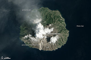
Paluweh, also known as Rokatenda, is a stratovolcano that forms the small island of Palu'e, north of Flores Island in Sikka Regency in the province of East Nusa Tenggara, Indonesia. While the volcano rises about 3,000 m (9,840 ft) above the sea floor, its cone rises just 875 metres (2,871 ft) above sea level and is the highest point on the island.

<span class="mw-page-title-main">Kelud</span> Stratovolcano in East Java, Indonesia.

The Kelud is an mountain stratovolcano located in Kediri, East Java, Indonesia. Like many Indonesian volcanoes and others on the Pacific Ring of Fire, Kelud is known for large explosive eruptions throughout its history. More than 30 eruptions have occurred since 1000 AD. In 2007, an effusive explosion filled the crater with a lava dome. It last erupted on 13 February 2014, destroying the lava dome and ejecting boulders, stones and ashes up to West Java about 500 kilometres (310 mi) from Mount Kelud. The crater filled with water during the rainy season.

<span class="mw-page-title-main">Anak Krakatoa</span> Volcanic island in the Sunda Strait

Anak Krakatoa is a volcanic island in Indonesia. On 29 December 1927, Anak Krakatoa first emerged from the caldera formed in 1883 by the explosive volcanic eruption that destroyed the island of Krakatoa. There has been sporadic eruptive activity at the site since the late 20th century, culminating with a large underwater collapse of the volcano that caused a deadly tsunami in December 2018. There has been subsequent activity since. Due to its young age, the island is one of several in the area that are of interest to, and the subject of extensive study by, volcanologists.

<span class="mw-page-title-main">Turrialba Volcano</span> Volcano in central Costa Rica

Turrialba Volcano is an active volcano in central Costa Rica that has been explosively eruptive in recent years including 2016 and in January, March and April 2017. Visitors used to be able to hike down into the main crater, but increased volcanic activity in 2014–17, resulting in large clouds of volcanic ash, caused the surrounding Turrialba Volcano National Park to close. However, with the subsiding of the eruptions, the park and volcano reopened on December 4, 2020.

<span class="mw-page-title-main">Mount Bulusan</span> Volcano in the Philippines

Mount Bulusan, also known as Bulusan Volcano, is a stratovolcano on the island of Luzon in the Philippines. Located in the province of Sorsogon in the Bicol Region, it is 70 kilometres (43 mi) southeast of Mayon Volcano and approximately 390 kilometres (240 mi) southeast of Manila. Bulusan is one of the active volcanoes in the Philippines.

<span class="mw-page-title-main">Kanlaon</span> Active volcano in the Philippines

Kanlaon, also known as Mount Kanlaon and Kanlaon Volcano, is an active stratovolcano and the highest mountain on the island of Negros in the Philippines, as well as the highest point in the Visayas, with an elevation of 2,465 m (8,087 ft) above sea level. Mount Kanlaon ranks as the 42nd-highest peak of an island in the world.

<span class="mw-page-title-main">Mount Sinabung</span> Active volcano in North Sumatra, Indonesia

Mount Sinabung is a Pleistocene-to-Holocene stratovolcano of andesite and dacite in the Karo plateau of Karo Regency, North Sumatra, Indonesia, 40 kilometres (25 mi) from the Lake Toba supervolcano. Many old lava flows are on its flanks and the last known eruption, before recent times, occurred 1200 years before present, between 740 - 880 CE. Solfataric activities were last observed at the summit in 1912; recent documented events include an eruption in the early hours of 29 August 2010 and eruptions in September and November 2013, January, February and October 2014. The volcano has recently claimed the life of at least 23 people in a number of events since 2014. Between 2013 and 2014, the alert for a major event was increased with no significant activity. On 2 June 2015, the alert was again increased, and on 26 June 2015, at least 10,000 people were evacuated, fearing a major eruption. The long eruption of Mount Sinabung is similar to that of Mount Unzen in Japan, which erupted for five years after lying dormant for 400 years. A major eruption began on 10 August 2020.

<span class="mw-page-title-main">2010 eruptions of Eyjafjallajökull</span> Volcanic events in Iceland

Between March and June 2010 a series of volcanic events at Eyjafjallajökull in Iceland caused enormous disruption to air travel across Western Europe.

<span class="mw-page-title-main">2010 eruptions of Mount Merapi</span> Volcanic eruption of Mount Merapi in Indonesia

In late October 2010, Mount Merapi in border of Central Java and Special Region of Yogyakarta, Indonesia began an increasingly violent series of eruptions that continued into November. Seismic activity around the volcano increased from mid-September onwards, culminating in repeated outbursts of lava and volcanic ash. Large eruption columns formed, causing numerous pyroclastic flows down the heavily populated slopes of the volcano. The 2010 eruption of Merapi was the volcano's largest since 1872.

<span class="mw-page-title-main">Shinmoedake</span> Volcano on the island of Kyushu, Japan

Shinmoedake is a volcano in Kagoshima Prefecture, Kyūshū, Japan, and a part of the Mount Kirishima cluster of volcanoes. It is believed to have formed between 7,300 and 25,000 years ago.

References

  1. 1 2 3 "Agung". Global Volcanism Program . Smithsonian Institution . Retrieved 23 January 2018.
  2. Anwari Dilmy. «Pioneer Plants Found One Year After the 1963 Eruption of Agung in Bali» / Pacific Science, Volume 19, Number 4, 1965, p. 498-501
  3. Heinrich Zollinger. Eein uirsrapje naar her eiland Bali / Tijdschr. Neer. Ind. 74:43, 1845.
  4. 1 2 Zen, M. T.; Hadikusumo, Djajadi (December 1964). "Preliminary report on the 1963 eruption of Mt.Agung in Bali (Indonesia)". Bulletin of Volcanology. 27 (1): 269–299. Bibcode:1964BVol...27..269Z. doi:10.1007/BF02597526. S2CID   128691551.
  5. 1 2 "Mount Agung: Bali volcano alert raised to highest level". BBC News. 27 November 2017. Retrieved 28 November 2017.
  6. "Population of Indonesia by Province 1971, 1980, 1990, 1995, 2000 and 2010". Badan Pusat Statistik (in Indonesian). Archived from the original on 3 December 2017. Retrieved 1 December 2017.
  7. 1 2 Global Volcanism Program. Sennert, Sally Kuhn (ed.). "Report on Agung (Indonesia)". Weekly Volcanic Activity Report, 13–19 September 2017. Smithsonian Institution and US Geological Survey. Archived from the original on 1 December 2017. Retrieved 28 November 2017.
  8. "Indonesian official: More than 120,000 flee Bali volcano". Fox News. 28 September 2017. Retrieved 28 September 2017.
  9. "Thousands evacuated as Bali volcano sparks fear". The Australian. 24 September 2017.
  10. "Mount Agung: facts about Bali's imminent volcano eruption". UbudHood. 23 September 2017. Retrieved 1 November 2017.
  11. "How do experts know Mount Agung is about to erupt?". ABC News Australia. 25 September 2017. Retrieved 1 November 2017.
  12. Once tremors detected, Bali volcano can erupt within hours: Volcanologist Archived 6 December 2017 at the Wayback Machine CNA, 3 October 2017
  13. Lamb, Kate (26 September 2017). "Bali volcano eruption could be hours away after unprecedented seismic activity". The Guardian. ISSN   0261-3077 . Retrieved 26 September 2017.
  14. Topsfield, Jewel; Rosa, Amilia (30 October 2017). "Mount Agung volcano alert in Bali downgraded". The Sydney Morning Herald. Retrieved 27 November 2017.
  15. Global Volcanism Program. Sennert, Sally Kuhn (ed.). "Report on Agung (Indonesia)". Weekly Volcanic Activity Report, 1–7 November 2017. Smithsonian Institution and US Geological Survey. Retrieved 28 November 2017.
  16. Global Volcanism Program. Sennert, Sally Kuhn (ed.). "Report on Agung (Indonesia)". Weekly Volcanic Activity Report, 8–14 November 2017. Smithsonian Institution and US Geological Survey. Retrieved 28 November 2017.
  17. "VONA". Archived from the original on 30 June 2018. Retrieved 27 November 2017.
  18. "Bali's Mount Agung volcano erupts". BBC News. 21 November 2017. Retrieved 21 November 2017.
  19. Regular bulletins are posted on the website of the Indonesian National Disaster Management Agency.
  20. 1 2 3 "Gunung Agung volcano (Bali, Indonesia): eruption has begun". Volcano Discovery. 26 November 2017. Retrieved 15 September 2019.
  21. "'Get out now' 100,000 people told as Bali volcano continues to spew ash". Metro. 27 November 2017. Retrieved 27 November 2017.
  22. "A volcanologist explains Bali eruption photos". BBC News. 27 November 2017. Retrieved 28 November 2017.
  23. Saifulbahri Ismail (27 November 2017). "Mount Agung eruption: Bali airport closed, flights cancelled". CNA. Archived from the original on 27 November 2017. Retrieved 27 November 2017.
  24. 1 2 "Locals Watch As Lahars From Mount Agung Sweep Away Rice Fields". VIVA Indonesia (in Indonesian). 27 November 2017. Retrieved 27 November 2017.
  25. "Mount Agung: Bali volcano alert raised to highest level". BBC News Online. 27 November 2017. Retrieved 27 November 2017.
  26. 1 2 "Life-saving technology provides alert as Bali's Mount Agung spews ash, raises alarm". www.pdc.org. 27 November 2017. Archived from the original on 1 December 2017. Retrieved 28 November 2017.
  27. "Volcanic ash update for Mount Agung". Australian Government Bureau of Meteorology. 27 November 2017. Retrieved 27 November 2017.
  28. "Indonesia reopens Bali airport as wind clears volcanic ash". Reuters.com. 29 November 2017.
  29. 1 2 "Bali volcano: live updates on Mount Agung eruptions as airport reopens". Evening Standard. 29 November 2017.
  30. Volcano erupts in Indonesia's Bali, airport remains safe
  31. "Bali's Mount Agung erupts, shooting ash cloud into sky". PerthNow. 14 June 2018. Retrieved 16 August 2020.
  32. "Bali volcano eruption: Mount Agung spews volcanic ash triggering CLOSURE of airport". Express Newspapers. 29 June 2018. Retrieved 29 June 2018.
  33. "Mount Agung: Bali flight chaos continues as more airlines cancel". The West Australian. 29 June 2018. Retrieved 29 June 2018.
  34. "700 flee 'thunderous' explosions and lava as Mount Agung erupts again". Australian Broadcasting Corporation. 3 July 2018.
  35. 1 2 "Bali's Mount Agung erupts again". News.com.au. 30 December 2018.
  36. "Indonesia's Mount Agung volcano erupts again". The Straits Times . 11 January 2019.
  37. "Agung volcano news & activity updates". 8 January 2019.
  38. "Bali airport operations normal despite Mt. Agung eruption".
  39. "Mount Agung erupts, spewing out 2,000-meter high column of ash".
  40. "Mount Agung: Flights resume after Bali volcano disruption". BBC News. 25 May 2019. Retrieved 25 May 2019.
  41. Agung volcano (Bali, Indonesia): strong explosion this morning, ash to 30,000 ft, 13 June 2019, retrieved 14 June 2019
  42. von Marc Szeglat (13 June 2019), Explosion am Gunung Agung (in German), retrieved 14 June 2019
  43. "Lombok International Airport closed due to volcanic ash from Mount Agung" . Retrieved 29 November 2017.
  44. "Bali volcano: State of emergency EXTENDED as Lombok airport closed over dangerous ash". 30 November 2017. Retrieved 30 November 2017.
  45. "Bali airport remains closed for a third day" . Retrieved 29 November 2017.
  46. "Mount Agung: Bali Airport Closed And 59,000 Passengers Affected By Cancelled Flights" . Retrieved 29 November 2017.[ permanent dead link ]