
The Tropic of Cancer, also known as the Northern Tropic, is the Earth's northernmost circle of latitude where the Sun can be seen directly overhead. This occurs on the June solstice, when the Northern Hemisphere is tilted toward the Sun to its maximum extent. It also reaches 90 degrees below the horizon at solar midnight on the December Solstice. Using a continuously updated formula, the circle is currently 23°26′09.9″ (or 23.43609°) north of the Equator.

The Tropic of Capricorn is the circle of latitude that contains the subsolar point at the December solstice. It is thus the southernmost latitude where the Sun can be seen directly overhead. It also reaches 90 degrees below the horizon at solar midnight on the June Solstice. Its northern equivalent is the Tropic of Cancer.

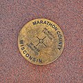
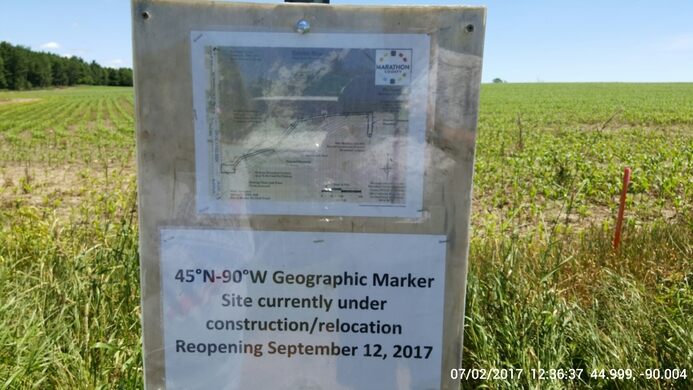
Marathon County is a county located in the U.S. state of Wisconsin. As of the 2020 census, the population was 138,013. Its county seat is Wausau. It was founded in 1850, created from a portion of Portage County. At that time the county stretched to the northern border with the upper Michigan peninsula. It is named after the battlefield at Marathon, Greece.

The Town of Rietbrock is located in Marathon County, Wisconsin, United States. It is part of the Wausau, WI Metropolitan Statistical Area. The town contains one of the four 45×90 points of the world, where the 45th parallel north and 90th meridian west intersect. The population was 981 at the 2010 census. The unincorporated communities of Poniatowski and Schnappsville are located within the town.

Suring is a village in Oconto County, Wisconsin, United States, along the 45th parallel. The population was 544 at the 2010 census. It is part of the Green Bay Metropolitan Statistical Area.

Cape Agulhas is a rocky headland in Western Cape, South Africa. It is the geographic southern tip of Africa and the beginning of the traditional dividing line between the Atlantic and Indian Oceans according to the International Hydrographic Organization. It is approximately half a degree of latitude, or 55 kilometres (34 mi), further south than the Cape of Good Hope.

In geography, a pole of inaccessibility is the farthest location in a given landmass, sea, or other topographical feature, starting from a given boundary, relative to a given criterion. A geographical criterion of inaccessibility marks a location that is the most challenging to reach according to that criterion. Often it refers to the most distant point from the coastline, implying the farthest point into a landmass from the shore, or the farthest point into a body of water from the shore. In these cases, a pole of inaccessibility is the center of a maximally large circle that can be drawn within an area of interest only touching but not crossing a coastline. Where a coast is imprecisely defined, the pole will be similarly imprecise.
This article lists extreme locations on Earth that hold geographical records or are otherwise known for their geophysical or meteorological superlatives. All of these locations are Earth-wide extremes; extremes of individual continents or countries are not listed.

The Willamette Stone was a small stone obelisk originally installed by the Department of Interior in 1885 in the western hills of Portland, Oregon, in the United States to mark the intersection and origin of the Willamette meridian and Willamette baseline. It replaced a cedar stake placed by the Surveyor General of the Oregon Territory in 1851; this stake defined the grid system of sections and townships from which all real property in the states of Oregon and Washington has been measured following the Donation Land Claim Act of 1850. The Willamette meridian runs north–south, and the Willamette baseline runs east–west through the marker. The easternmost northeast corner of Washington County is sited on the marker.

The 45th parallel south is a circle of latitude that is 45° south of the Earth's equator.

The following lists include extreme and significant points of the geography of Canada.
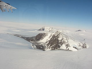
The Thiel Mountains are isolated, mainly snow-capped mountains of the Transantarctic Mountains System, located in the Ellsworth Land region of Antarctica. The mountain range is 45 nautical miles long, is located roughly between the Horlick Mountains and the Pensacola Mountains, and extends from Moulton Escarpment on the west to Nolan Pillar on the east. Major components include Ford Massif, Bermel Escarpment and a group of eastern peaks near Nolan Pillar.
Poniatowski is an unincorporated community, in the town of Rietbrock, Marathon County, Wisconsin, United States. The area is geographically notable for being less than one mile away from the 45°N, 90°W point. It's most likely named after a Polish royal family of the same name.
The 45th parallel north is a circle of latitude that is 45 degrees north of Earth's equator. It crosses Europe, Asia, the Pacific Ocean, North America, and the Atlantic Ocean. The 45th parallel north is often called the halfway point between the equator and the North Pole, but the true halfway point is 16.0 km (9.9 mi) north of it because Earth is an oblate spheroid; that is, it bulges at the equator and is flattened at the poles.
German submarine U-253 was a Type VIIC U-boat built for Nazi Germany's Kriegsmarine for service during World War II.
Ayrens is a commune in the Cantal department in the Auvergne-Rhône-Alpes region of south-central France.
The meridian 90° west of Greenwich is a line of longitude that extends from the North Pole across the Arctic Ocean, North America, the Gulf of Mexico, Central America, the Pacific Ocean, the Southern Ocean, and Antarctica to the South Pole.
The equator is a circle of latitude that divides a spheroid, such as Earth, into the Northern and Southern hemispheres. On Earth, the Equator is an imaginary line located at 0 degrees latitude, about 40,075 km (24,901 mi) in circumference, halfway between the North and South poles. The term can also be used for any other celestial body that is roughly spherical.

The Antarctic Circle is the most southerly of the five major circles of latitude that mark maps of Earth. The region south of this circle is known as the Antarctic, and the zone immediately to the north is called the Southern Temperate Zone. South of the Antarctic Circle, the Sun is above the horizon for 24 continuous hours at least once per year and the centre of the Sun is below the horizon for 24 continuous hours at least once per year ; this is also true within the equivalent polar circle in the Northern Hemisphere, the Arctic Circle.
Jiangjunmiao is a ruin and fossil site in Changji Hui Autonomous Prefecture, Xinjiang, China.


