
Bremen-Verden, formally the Duchies of Bremen and Verden, were two territories and immediate fiefs of the Holy Roman Empire, which emerged and gained imperial immediacy in 1180. By their original constitution they were prince-bishoprics of the Archdiocese of Bremen and Bishopric of Verden.

Kranenburg is a municipality in the district Stade, Lower Saxony, Germany, lying on the river Oste. It consists of the villages Kranenburg and Brobergen and is part of the Samtgemeinde Oldendorf-Himmelpforten. It has a population of 772 as at December 31, 2003, of which 546 in Kranenburg and 226 in Brobergen.

Apensen is a municipality southwest of Hamburg (Germany). Apensen has a population of about 3,000, the area of 20.74 km² and belongs to the district Stade, Lower Saxony.

Oldendorf is a municipality in the district of Stade, in Lower Saxony, Germany. It is situated west of Hamburg. Oldendorf has a population of approx. 3,000. Oldendorf was the seat of the former Samtgemeinde Oldendorf.

Fredenbeck is a municipality northwest of Hamburg (Germany) in the district of Stade in Lower Saxony.

Harsefeld is a municipality situated south-west of Hamburg (Germany). Harsefeld has a population of c. 12,500 and belongs to the district of Stade, Lower Saxony.

Himmelpforten is a municipality west of Hamburg (Germany) in the district of Stade in Lower Saxony. It is located on the Horsterbeck creek. Himmelpforten is also part and the seat of the Samtgemeinde Oldendorf-Himmelpforten.

Horneburg is a municipality southwest of Hamburg (Germany) in the district of Stade in Lower Saxony.

Bad Bederkesa is a village and a former municipality in the district of Cuxhaven, in Lower Saxony, Germany. Since 1 January 2015 it is part of the town of Geestland. It is situated approximately 20 km northeast of Bremerhaven, and 30 km southeast of Cuxhaven. Bad Bederkesa was the seat of the former Samtgemeinde Bederkesa, an administrative division consisting of several component municipalities.

Beverstedt is a municipality in the district of Cuxhaven, in Lower Saxony, Germany. It is situated approximately 20 km southeast of Bremerhaven, and 40 km north of Bremen.
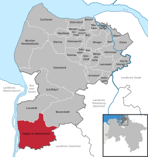
Hagen im Bremischen is a municipality in the district of Cuxhaven, in Lower Saxony, Germany. It is situated approximately 20 km south of Bremerhaven, and 35 km northwest of Bremen. Hagen was the seat of the former Samtgemeinde Hagen.

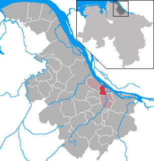
Hemmoor is a small town in the district of Cuxhaven, in Lower Saxony, Germany. It is situated near the river Oste, approx. 40 km northeast of Bremerhaven, and 25 km south of Brunsbüttel.

Hambergen is a municipality in the district of Osterholz, in Lower Saxony, Germany. It is situated approximately 10 km north of Osterholz-Scharmbeck, and 25 km north of Bremen.

Selsingen is a municipality in the district of Rotenburg, in Lower Saxony, Germany. It is situated approximately 15 kilometres (9.3 mi) southeast of Bremervörde, and 45 kilometres (28 mi) northeast of Bremen, and is twinned with the English village of Sawston in Cambridgeshire.
Sittensen is a municipality in the district of Rotenburg, in Lower Saxony, Germany. It is situated approximately 20 km northeast of Rotenburg, and 45 km southwest of Hamburg.

Tarmstedt is a municipality in the district of Rotenburg in Lower Saxony, Germany. It is situated approximately 25 km northwest of Rotenburg, and 25 km northeast of Bremen.

Mittelstenahe is a municipality in the district of Cuxhaven, in Lower Saxony, Germany.

Düdenbüttel is a municipality in the district of Stade, Lower Saxony, Germany.

Hollern-Twielenfleth is a municipality in the district of Stade, Lower Saxony, Germany.
Steinkirchen is a municipality in the district of Stade, Lower Saxony, Germany.


