Mittelnkirchen

Last updated

Mittelnkirchen
Mittelnkirchen (German)
Mittelskark (Low Saxon)
Wappen Mittelnkirchen.gif
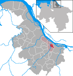
Location of Mittelnkirchen within Stade district
Mittelnkirchen in STD.png
Germany adm location map.svg
Red pog.svg
Mittelnkirchen
Lower Saxony location map.svg
Red pog.svg
Mittelnkirchen
Coordinates: 53°33′N9°37′E / 53.550°N 9.617°E / 53.550; 9.617 Coordinates: 53°33′N9°37′E / 53.550°N 9.617°E / 53.550; 9.617
Country Germany
State Lower Saxony
District Stade
Municipal assoc. Lühe
Government
   Mayor Joachim Streckwaldt (CDU)
Area
  Total7.02 km2 (2.71 sq mi)
Elevation
1 m (3 ft)
Population
 (2020-12-31) [1]
  Total1,138
  Density160/km2 (420/sq mi)
Time zone UTC+01:00 (CET)
  Summer (DST) UTC+02:00 (CEST)
Postal codes
21720
Dialling codes 04142
Vehicle registration STD
Website www.luehe-online.de

Mittelnkirchen (in High German, in Low Saxon: Mittelskark) is a municipality in the district of Stade, Lower Saxony, Germany.

Contents

History

Mittelnkirchen belonged - as to its government - to the Prince-Archbishopric of Bremen, established in 1180. [2] In religious respect, however, Mittelnkirchen formed part of the Roman Catholic Diocese of Verden until after 1566 its incumbent bishops lost papal recognition, except of a last Catholic bishop from 1630 to 1631, respectively. [2] In the mid-16th century the inhabitants adopted Lutheranism. During the Leaguist occupation under Tilly (1628–1630), they suffered from attempts of re-Catholicisation.

In 1648 the prince-archbishopric was transformed into the Duchy of Bremen, which was first ruled in personal union by the Swedish – interrupted by a Danish occupation (1712–1715) – and from 1715 on by the Hanoverian Crown. In 1807 the ephemeric Kingdom of Westphalia annexed the duchy, before France annexed it in 1810. In 1813 the duchy was restored to the Electorate of Hanover, which – after its upgrade to the Kingdom of Hanover in 1814 – incorporated the duchy in a real union and the ducal territory, including Mittelnkirchen, became part of the Stade Region, established in 1823.

Related Research Articles

Stade Place in Lower Saxony, Germany

Stade, officially the Hanseatic City of Stade is a city in Lower Saxony in northern Germany. First mentioned in records in 934, it is the seat of the district which bears its name. It is located roughly 45 km (28 mi) to the west of Hamburg and belongs to that city's wider metropolitan region. Within the area of the city are the urban districts of Bützfleth, Hagen, Haddorf and Wiepenkathen, each of which have a council of their own with some autonomous decision-making rights.

Bremen-Verden

Bremen-Verden, formally the Duchies of Bremen and Verden, were two territories and immediate fiefs of the Holy Roman Empire, which emerged and gained imperial immediacy in 1180. By their original constitution they were prince-bishoprics of the Archdiocese of Bremen and Bishopric of Verden.

Bremervörde Place in Lower Saxony, Germany

Bremervörde is a town in the north of the district (Landkreis) of Rotenburg, in Lower Saxony, Germany. It is situated on the Oste river near the centre of the "triangle" formed by the rivers Weser and Elbe, roughly equidistant from the cities of Hamburg, Bremen and Cuxhaven.

Jork Place in Lower Saxony, Germany

Jork is a small town on the left bank of the Elbe, near Hamburg (Germany).

Himmelpforten Place in Lower Saxony, Germany

Himmelpforten is a municipality west of Hamburg (Germany) in the district of Stade in Lower Saxony. It is located on the Horsterbeck creek. Himmelpforten is also part and the seat of the Samtgemeinde Oldendorf-Himmelpforten.

Neuhaus (Oste) Place in Lower Saxony, Germany

Neuhaus an der Oste is a municipality in the district of Cuxhaven, in Lower Saxony, Germany.

Selsingen Place in Lower Saxony, Germany

Selsingen is a municipality in the district of Rotenburg, in Lower Saxony, Germany. It is situated approximately 15 kilometres (9.3 mi) southeast of Bremervörde, and 45 kilometres (28 mi) northeast of Bremen, and is twinned with the English village of Sawston in Cambridgeshire.

Sittensen Place in Lower Saxony, Germany

Sittensen is a municipality in the district of Rotenburg, in Lower Saxony, Germany. It is situated approximately 20 km northeast of Rotenburg, and 45 km southwest of Hamburg.

Ottersberg Place in Lower Saxony, Germany

Ottersberg is a municipality in the district of Verden, in Lower Saxony, Germany. It is situated approximately 20 km north of Verden, and 28 km east of Bremen.

Flögeln Ortsteil of Geestland in Lower Saxony, Germany

Flögeln is a village and a former municipality in the district of Cuxhaven, in Lower Saxony, Germany. Since 1 January 2015 it is part of the town Geestland.

Elsdorf, Lower Saxony Place in Lower Saxony, Germany

Elsdorf is a municipality in the district of Rotenburg, in Lower Saxony, Germany.

Neuenkirchen, Stade Place in Lower Saxony, Germany

Neuenkirchen is a municipality in the Altes Land, district of Stade, Lower Saxony, Germany.

Sauensiek Place in Lower Saxony, Germany

Sauensiek is a municipality in the district of Stade, Lower Saxony, Germany.

Rübke Ortsteil of Neu Wulmstorf in Lower Saxony, Germany

Rübke  a village located in the north of Lower Saxony, Germany. Its population is approximately 500 and consists of two main roads.

Cranz, Hamburg Quarter of Hamburg in Germany

Cranz is a quarter in the Harburg borough of Hamburg, Germany. It is on the left bank of the Elbe river and one of the 104 quarters of Hamburg. In 2016 the population was 826.

Valdemar of Denmark (bishop)

Valdemar Knudsen was a Danish clergyman and statesman. Valdemar was Bishop of Schleswig from 1188 to 1208, officiated as Steward of the Duchy of Schleswig between 1184 and 1187, and served as Prince-Archbishop of Bremen from 1192 to 1194 and again between 1206 and 1217. He held the latter office on the grounds of the archdiocesan capitular election as archbishop elect and of the royal investiture with the princely regalia, but lacked the papal confirmation.

Francop Quarter of Hamburg in Germany

Francop is a quarter in the Harburg borough of the Free and Hanseatic city of Hamburg in northern Germany. In 2016 the population was 672.

Himmelpforten Convent

Himmelpforten Convent was founded as a monastery of nuns following the Cistercian Rule during the 13th century in Himmelpforten, in today's Lower Saxony, Germany. During the 16th century, it was converted into use as a Lutheran Damsels' Convent. The Himmelpforten Convent was founded before 1255 and finally dissolved in 1647. The convent complex was built between 1300 and 1330. After 1645 the buildings, including the abbey, increasingly decayed, until they were little by little demolished. The dilapidated abbey was demolished in 1737 and replaced by today's St. Mary's Church which partially covers the foundations of the former abbey.

Neuenwalde Convent

The Neuenwalde Convent is a Lutheran damsels' convent in Neuenwalde, a locality of Geestland, Lower Saxony, Germany.

References

  1. Landesamt für Statistik Niedersachsen, LSN-Online Regionaldatenbank, Tabelle A100001G: Fortschreibung des Bevölkerungsstandes, Stand 31. Dezember 2020.
  2. 1 2 Michael Schütz, "Die Konsolidierung des Erzstiftes unter Johann Rode“, in: Geschichte des Landes zwischen Elbe und Weser: 3 vols., Hans-Eckhard Dannenberg and Heinz-Joachim Schulze (eds.) on behalf of the Landschaftsverband der ehemaligen Herzogtümer Bremen und Verden, Stade: Landschaftsverband der ehemaligen Herzogtümer Bremen und Verden, 1995 and 2008, vol. I 'Vor- und Frühgeschichte' (1995; ISBN   978-3-9801919-7-5), vol. II 'Mittelalter (einschl. Kunstgeschichte)' (1995; ISBN   978-3-9801919-8-2), vol. III 'Neuzeit' (2008; ISBN   978-3-9801919-9-9), (=Schriftenreihe des Landschaftsverbandes der ehemaligen Herzogtümer Bremen und Verden; vols. 7–9), vol. II: pp. 263–278, here pp. 270seq. ISBN   978-3-9801919-8-2.