Harsefeld

Last updated

Harsefeld
Harsfeld
St. Marien und Bartholomai 20080708-1.jpg
View over the remnants of the former Archabbey towards the Lutheran church St.Marien und Bartholomäi
Wappen Harsefeld.gif
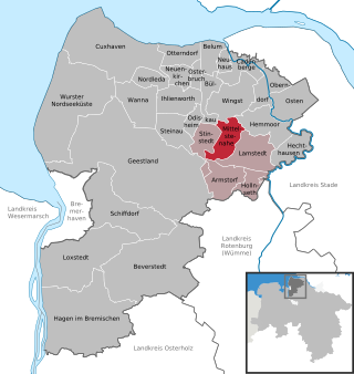
Location of Harsefeld within Stade district
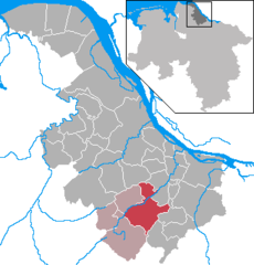
Harsefeld in STD.png
Germany adm location map.svg
Red pog.svg
Harsefeld
Lower Saxony location map.svg
Red pog.svg
Harsefeld
Coordinates: 53°27′N9°30′E / 53.450°N 9.500°E / 53.450; 9.500 Coordinates: 53°27′N9°30′E / 53.450°N 9.500°E / 53.450; 9.500
Country Germany
State Lower Saxony
District Stade
Municipal assoc. Harsefeld
Subdivisions4
Government
   Mayor Rainer Schlichtmann
Area
  Total51.81 km2 (20.00 sq mi)
Elevation
38 m (125 ft)
Population
 (2020-12-31) [1]
  Total14,245
  Density270/km2 (710/sq mi)
Time zone UTC+01:00 (CET)
  Summer (DST) UTC+02:00 (CEST)
Postal codes
21698
Dialling codes 04164
Vehicle registration STD
Website www.harsefeld.de

Harsefeld (in High German, in Low Saxon: Harsfeld; literally in horse field) is a municipality situated south-west of Hamburg (Germany). Harsefeld has a population of c. 12,500 and belongs to the district of Stade, Lower Saxony.

Contents

Harsefeld is also the seat of the Samtgemeinde ("collective municipality") Harsefeld.

History

In 1104 a Benedictine Archabbey  [ de ] was founded in Harsefeld, then within the Duchy of Saxony. After the carve-up of the duchy in 1180, Harsefeld belonged to the Prince-Archbishopric of Bremen, a new territory of imperial immediacy of the Holy Roman Empire. In the mid-16th century, when most inhabitants of the prince-archbishopric adopted Lutheranism, the archabbey remained a stronghold of Catholicism. During the Leaguist occupation under Tilly (1628–1630), the archabbey became a starting point for the attempts of re-Catholicisation.

In 1648 the prince-archbishopric was transformed into the Duchy of Bremen, which was first ruled in personal union by the Swedish crown. The new rulers dissolved the archabbey and most of its structures fell in ruins after 1648. From 1715 on, the House of Hanover ruled the duchy. In 1807 the ephemeric Kingdom of Westphalia annexed the Duchy, before France annexed it in 1810. In 1813 the Duchy was restored to the Electorate of Hanover, which – after its upgrade to the Kingdom of Hanover in 1814 – incorporated the Duchy in a real union and the Ducal territory, including Harsefeld, became part of the Stade Region, established in 1823.

People born in Harsefeld

Related Research Articles

Nordholz Ortsteil of Wurster Nordseeküste in Lower Saxony, Germany

Nordholz is a village and a former municipality in the district of Cuxhaven, in Lower Saxony, Germany. Since 1 January 2015 it is part of the municipality Wurster Nordseeküste. It is situated approximately 25 km north of Bremerhaven, and 12 km southwest of Cuxhaven.

Appeln Ortsteil of Beverstedt in Lower Saxony, Germany

Appeln is a village and a former municipality in the district of Cuxhaven, in Lower Saxony, Germany. Since 1 November 2011, it is part of the municipality Beverstedt.

Driftsethe Ortsteil of Hagen im Bremischen in Lower Saxony, Germany

Driftsethe is a village and a former municipality in the district of Cuxhaven, in Lower Saxony, Germany. Since 1 January 2014, it is part of the municipality Hagen im Bremischen.

Frelsdorf Ortsteil of Beverstedt in Lower Saxony, Germany

Frelsdorf is a village and a former municipality in the district of Cuxhaven, in Lower Saxony, Germany. Since 1 November 2011, it is part of the municipality Beverstedt.

Hollen Ortsteil of Beverstedt in Lower Saxony, Germany

Hollen is a village and a former municipality in the district of Cuxhaven, in Lower Saxony, Germany. Since 1 November 2011, it is part of the municipality Beverstedt.

Lunestedt Ortsteil of Beverstedt in Lower Saxony, Germany

Lunestedt is a village and a former municipality in the district of Cuxhaven, in Lower Saxony, Germany. Since 1 November 2011, it is part of the municipality Beverstedt.

Mittelstenahe Place in Lower Saxony, Germany

Mittelstenahe is a municipality in the district of Cuxhaven, in Lower Saxony, Germany.

Deinstedt Place in Lower Saxony, Germany

Deinstedt is a municipality in the district of Rotenburg, in Lower Saxony, Germany.

Farven Place in Lower Saxony, Germany

Farven is a municipality in the district of Rotenburg, in Lower Saxony, Germany.

Hamersen Place in Lower Saxony, Germany

Hamersen is a municipality in the district of Rotenburg, in Lower Saxony, Germany.

Hepstedt Place in Lower Saxony, Germany

Hepstedt is a municipality in the district of Rotenburg, in Lower Saxony, Germany.

Hipstedt Place in Lower Saxony, Germany

Hipstedt is a municipality in the district of Rotenburg, in Lower Saxony, Germany.

Lengenbostel Place in Lower Saxony, Germany

Lengenbostel is a municipality in the district of Rotenburg, in Lower Saxony, Germany.

Oerel Place in Lower Saxony, Germany

Oerel is a municipality in the district of Rotenburg, in Lower Saxony, Germany.

Vorwerk, Lower Saxony Place in Lower Saxony, Germany

Vorwerk is a municipality in the district of Rotenburg, in Lower Saxony, Germany.

Westertimke Place in Lower Saxony, Germany

Westertimke is a municipality in the district of Rotenburg, in Lower Saxony, Germany.

Wilstedt Place in Lower Saxony, Germany

Wilstedt is a municipality in the district of Rotenburg, in Lower Saxony, Germany.

Hammah Place in Lower Saxony, Germany

Hammah is a municipality in the district of Stade, in Lower Saxony, Germany.

Heinbockel Place in Lower Saxony, Germany

Heinbockel is a municipality in the district of Stade, Lower Saxony, Germany.

Krummendeich Place in Lower Saxony, Germany

Krummendeich is a municipality in the district of Stade, in Lower Saxony, Germany.

References

Commons-logo.svg Media related to Harsefeld at Wikimedia Commons