Dollern

Last updated
Dollern
Location of Dollern within Stade district
Dollern in STD.png
Germany adm location map.svg
Red pog.svg
Dollern
Lower Saxony location map.svg
Red pog.svg
Dollern
Coordinates: 53°32′20″N9°33′00″E / 53.53889°N 9.55000°E / 53.53889; 9.55000 Coordinates: 53°32′20″N9°33′00″E / 53.53889°N 9.55000°E / 53.53889; 9.55000
Country Germany
State Lower Saxony
District Stade
Municipal assoc. Horneburg
Government
   Mayor Wilfried Ehlers (SPD)
Area
  Total11.96 km2 (4.62 sq mi)
Elevation
17 m (56 ft)
Population
 (2020-12-31) [1]
  Total2,242
  Density190/km2 (490/sq mi)
Time zone UTC+01:00 (CET)
  Summer (DST) UTC+02:00 (CEST)
Postal codes
21739
Dialling codes 04163
Vehicle registration STD
Website horneburg.de

Dollern is a municipality in the district of Stade, Lower Saxony, Germany. In 2006 the population was 1,747.

Contents

History

Dollern belonged to the Prince-Archbishopric of Bremen, established in 1180. In 1648 the Prince-Archbishopric was transformed into the Duchy of Bremen, which was first ruled in personal union by the Swedish Crown - interrupted by a Danish occupation (1712–1715) - and from 1715 on by the Hanoverian Crown. In 1807 the ephemeric Kingdom of Westphalia annexed the Duchy, before France annexed it in 1810. In 1813 the Duchy was restored to the Electorate of Hanover, which - after its upgrade to the Kingdom of Hanover in 1814 - incorporated the Duchy in a real union and the Ducal territory, including Dollern, became part of the new Stade Region, established in 1823.

Demography

In 2006 the population was 1,747. [2]

Transport

The rapid transit system of Hamburg S-Bahn serves Dollern at the railway station with the trains of the line S3. [3]

Related Research Articles

Oldendorf, Stade Place in Lower Saxony, Germany

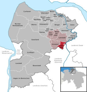
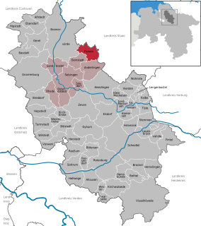
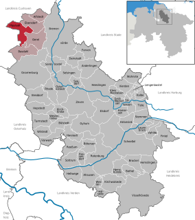
Oldendorf is a municipality in the district of Stade, in Lower Saxony, Germany. It is situated west of Hamburg. Oldendorf has a population of approx. 3,000. Oldendorf was the seat of the former Samtgemeinde Oldendorf.

Hollnseth Place in Lower Saxony, Germany

Hollnseth is a municipality in the district of Cuxhaven, in Lower Saxony, Germany.

Alfstedt Place in Lower Saxony, Germany

Alfstedt is a municipality in the district of Rotenburg, in Lower Saxony, Germany.

Anderlingen Place in Lower Saxony, Germany

Anderlingen is a municipality in the district of Rotenburg, in Lower Saxony, Germany.

Bülstedt Place in Lower Saxony, Germany

Bülstedt is a municipality in the district of Rotenburg, in Lower Saxony, Germany.

Deinstedt Place in Lower Saxony, Germany

Deinstedt is a municipality in the district of Rotenburg, in Lower Saxony, Germany.

Ebersdorf, Lower Saxony Place in Lower Saxony, Germany

Ebersdorf is a municipality in the district of Rotenburg, in Lower Saxony, Germany.

Farven Place in Lower Saxony, Germany

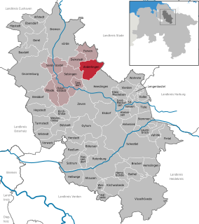
Farven is a municipality in the district of Rotenburg, in Lower Saxony, Germany.

Hamersen Place in Lower Saxony, Germany

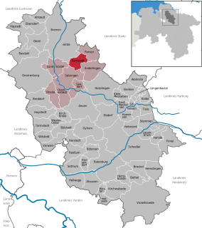
Hamersen is a municipality in the district of Rotenburg, in Lower Saxony, Germany.

Hepstedt Place in Lower Saxony, Germany

Hepstedt is a municipality in the district of Rotenburg, in Lower Saxony, Germany.

Hipstedt Place in Lower Saxony, Germany

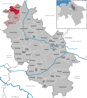
Hipstedt is a municipality in the district of Rotenburg, in Lower Saxony, Germany.

Lengenbostel Place in Lower Saxony, Germany

Lengenbostel is a municipality in the district of Rotenburg, in Lower Saxony, Germany.

Oerel Place in Lower Saxony, Germany

Oerel is a municipality in the district of Rotenburg, in Lower Saxony, Germany.

Ostereistedt Place in Lower Saxony, Germany

Ostereistedt is a municipality in the district of Rotenburg, in Lower Saxony, Germany.

Vorwerk, Lower Saxony Place in Lower Saxony, Germany

Vorwerk is a municipality in the district of Rotenburg, in Lower Saxony, Germany.

Westertimke Place in Lower Saxony, Germany

Westertimke is a municipality in the district of Rotenburg, in Lower Saxony, Germany.

Agathenburg Place in Lower Saxony, Germany

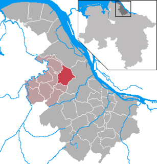
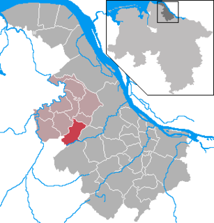
Agathenburg is a municipality in the district of Stade, Lower Saxony, Germany. It was formerly known as Leith.

Bliedersdorf Place in Lower Saxony, Germany

Bliedersdorf is a municipality in the district of Stade, Lower Saxony, Germany. It is east of Nottensdorf, southwest of Horneburg, and northwest of the simple dolmen megaliths of Grundoldendorf.

Hammah Place in Lower Saxony, Germany

Hammah is a municipality in the district of Stade, in Lower Saxony, Germany.

Heinbockel Place in Lower Saxony, Germany

Heinbockel is a municipality in the district of Stade, Lower Saxony, Germany.

References

  1. Landesamt für Statistik Niedersachsen, LSN-Online Regionaldatenbank, Tabelle A100001G: Fortschreibung des Bevölkerungsstandes, Stand 31. Dezember 2020.
  2. Selectable database. "NLS-Online, die größte regionalstatistische Datenbank Deutschlands Statistik-Regional-Niedersachsen" (in German). Landesbetrieb für Statistik und Kommunikationstechnologie Niedersachsen. Retrieved 2009-10-09.
  3. Staff (2009-10-07), Rapid Transit/Regional Rail (Network plan, pdf) (PDF), Hamburger Verkehrsverbund, archived from the original (PDF) on 2009-01-17, retrieved 2009-02-07