Wischhafen

Last updated
Wischhafen
Luftaufnahmen Nordseekueste 2012-05-by-RaBoe-455.jpg
DEU Wischhafen COA.svg
Coat of arms
Germany adm location map.svg
Red pog.svg
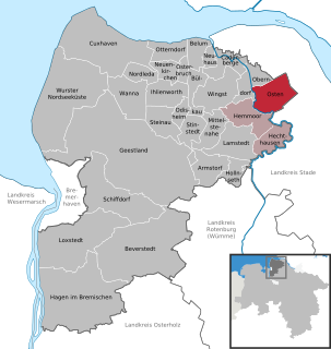
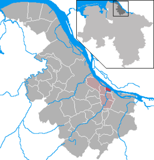
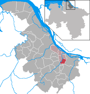
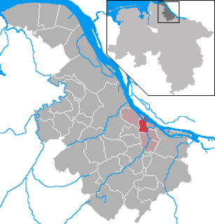
Wischhafen
Location of Wischhafen within Stade district
Wischhafen in STD.png
Coordinates: 53°46′14″N09°18′58″E / 53.77056°N 9.31611°E / 53.77056; 9.31611 Coordinates: 53°46′14″N09°18′58″E / 53.77056°N 9.31611°E / 53.77056; 9.31611
Country Germany
State Lower Saxony
District Stade
Municipal assoc. Nordkehdingen
Government
   Mayor Heinrich von Borstel (SPD)
Area
  Total 33.68 km2 (13.00 sq mi)
Elevation 1 m (3 ft)
Population (2015-12-31) [1]
  Total 2,956
  Density 88/km2 (230/sq mi)
Time zone CET/CEST (UTC+1/+2)
Postal codes 21737
Dialling codes 04770, 04779
Vehicle registration STD
Website www.nordkehdingen.de

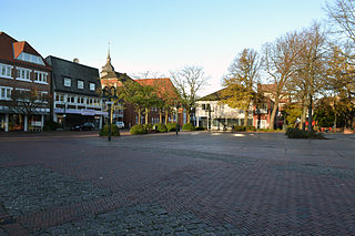
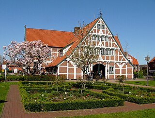
Wischhafen (low German Wischhoben) is a municipality in the district of Stade, in Lower Saxony, Germany.

Low German West Germanic language spoken mainly in northern Germany and the eastern part of the Netherlands

Low German or Low Saxon is a West Germanic language spoken mainly in Northern Germany and the northeastern part of the Netherlands. It is also spoken to a lesser extent in the German diaspora worldwide.

Stade is a district (Landkreis) in Lower Saxony, Germany. It has its seat in Stade and is bounded by the districts of Harburg, Rotenburg and Cuxhaven, the Elbe River, and the city state of Hamburg.

Lower Saxony State in Germany

Lower Saxony is a German state (Land) situated in northwestern Germany. It is the second-largest state by land area, with 47,624 km2 (18,388 sq mi), and fourth-largest in population among the 16 Länder federated as the Federal Republic of Germany. In rural areas, Northern Low Saxon and Saterland Frisian are still spoken, but the number of speakers is declining.

Contents

History

It belonged to the Prince-Archbishopric of Bremen. In 1648 the Prince-Archbishopric was transformed into the Duchy of Bremen, which was first ruled in personal union by the Swedish and from 1715 on by the Hanoverian Crown. In 1823 the Duchy was abolished and its territory became part of the Stade Region.

A personal union is the combination of two or more states that have the same monarch while their boundaries, laws, and interests remain distinct. A real union, by contrast, would involve the constituent states being to some extent interlinked, such as by sharing some limited governmental institutions. In a federation and a unitary state, a central (federal) government spanning all member states exists, with the degree of self-governance distinguishing the two. The ruler in a personal union does not need to be a hereditary monarch.

The Stade Region emerged in 1823 by an administrative reorganisation of the dominions of the Kingdom of Hanover, a sovereign state, whose then territory is almost completely part of today's German federal state of Lower Saxony. Until 1837 the Kingdom of Hanover was ruled in personal union by the Kings of the United Kingdom of Great Britain and Ireland.

Geography

In the north of Wischhafen is the Elbe river. In the East is the South Elbe River. In the South of Wischhafen is the village Drochtersen. In the north are the two villages Freiburg and Oederquart.

Parts of the municipality

Wischhafen has the following parts:

Literature

Uthlede Ortsteil of Hagen im Bremischen in Lower Saxony, Germany

Uthlede is a village and a former municipality in the district of Cuxhaven, in Lower Saxony, Germany. Since 1 January 2014, it is part of the municipality Hagen im Bremischen.

International Standard Book Number Unique numeric book identifier

The International Standard Book Number (ISBN) is a numeric commercial book identifier which is intended to be unique. Publishers purchase ISBNs from an affiliate of the International ISBN Agency.

Related Research Articles

Kranenburg, Lower Saxony Place in Lower Saxony, Germany

Kranenburg is a municipality in the district Stade, Lower Saxony, Germany, lying on the river Oste. It consists of the villages Kranenburg and Brobergen and is part of the Samtgemeinde Oldendorf-Himmelpforten. It has a population of 772 as at December 31, 2003, of which 546 in Kranenburg and 226 in Brobergen.

Bremervörde Place in Lower Saxony, Germany

Bremervörde is a town in the north of the district (Landkreis) of Rotenburg, in Lower Saxony, Germany. It is situated on the Oste river near the centre of the "triangle" formed by the rivers Weser and Elbe, roughly equidistant from the cities of Hamburg, Bremen and Cuxhaven.

Jork Place in Lower Saxony, Germany

Jork is a small town on the left bank of the Elbe, near Hamburg (Germany).

Drochtersen Place in Lower Saxony, Germany

Drochtersen is a municipality in the district Stade, in Lower Saxony (Germany). It is located 45 km north west of Hamburg.

Fredenbeck Place in Lower Saxony, Germany

Fredenbeck is a municipality northwest of Hamburg (Germany) in the district of Stade in Lower Saxony.

Osten Place in Lower Saxony, Germany

Osten is a municipality in the district of Cuxhaven, in Lower Saxony, Germany. It is situated on the river Oste. Osten also means "East" in German.

Hemmoor Place in Lower Saxony, Germany

Hemmoor is a municipality in the district of Cuxhaven, in Lower Saxony, Germany. It is situated near the river Oste, approx. 40 km northeast of Bremerhaven, and 25 km south of Brunsbüttel.

Neuhaus (Oste) Place in Lower Saxony, Germany

Neuhaus an der Oste is a municipality in the district of Cuxhaven, in Lower Saxony, Germany.

Schwanewede Place in Lower Saxony, Germany

Schwanewede is a municipality in the district of Osterholz, in Lower Saxony, Germany. It is situated approximately 14 km west of Osterholz-Scharmbeck, and 22 km northwest of Bremen.

Selsingen Place in Lower Saxony, Germany

Selsingen is a municipality in the district of Rotenburg, in Lower Saxony, Germany. It is situated approximately 15 kilometres (9.3 mi) southeast of Bremervörde, and 45 kilometres (28 mi) northeast of Bremen, and is twinned with the English village of Sawston in Cambridgeshire.

Sittensen Place in Lower Saxony, Germany

Sittensen is a municipality in the district of Rotenburg, in Lower Saxony, Germany. It is situated approximately 20 km northeast of Rotenburg, and 45 km southwest of Hamburg.

Elsdorf, Lower Saxony Place in Lower Saxony, Germany

Elsdorf is a municipality in the district of Rotenburg, in Lower Saxony, Germany.

Bliedersdorf Place in Lower Saxony, Germany

Bliedersdorf is a municipality in the district of Stade, Lower Saxony, Germany. It is east of Nottensdorf, southwest of Horneburg, and northwest of the simple dolmen megaliths of Grundoldendorf.

Freiburg, Lower Saxony Place in Lower Saxony, Germany

Freiburg (in High German, officially Freiburg an der Elbe; short: Freiburg/Elbe, Freiborg/Elv, or Freiborg is a municipality in the district of Stade, Lower Saxony, Germany.

Grünendeich Place in Lower Saxony, Germany

Grünendeich is a municipality in the district of Stade, Lower Saxony, Germany.

Hollern-Twielenfleth Place in Lower Saxony, Germany

Hollern-Twielenfleth is a municipality in the district of Stade, Lower Saxony, Germany.

Mittelnkirchen Place in Lower Saxony, Germany

Mittelnkirchen is a municipality in the district of Stade, Lower Saxony, Germany.

Neuenkirchen, Stade Place in Lower Saxony, Germany

Neuenkirchen is a municipality in the Altes Land, district of Stade, Lower Saxony, Germany.

Sauensiek Place in Lower Saxony, Germany

Sauensiek is a municipality in the district of Stade, Lower Saxony, Germany.

Steinkirchen, Lower Saxony Place in Lower Saxony, Germany

Steinkirchen is a municipality in the district of Stade, Lower Saxony, Germany.

References