Ahuriri

Last updated

Ahuriri
Ahuriri.jpg
Ahuriri viewed from Westshore Beach
Ahuriri
Coordinates: 39°28′53″S176°53′53″E / 39.481459°S 176.897960°E / -39.481459; 176.897960
CountryNew Zealand
City Napier
Local authority Napier City Council
Electoral wardAhuriri Ward
Area
[1]
  Land98 ha (242 acres)
Population
 (June 2023) [2]
  Total1,120
Westshore (Hawke Bay)
Pfeil oben.svg
Pfeil links.svgAhuririPfeil rechts.svg
Pfeil unten.svg
Onekawa Hospital Hill Bluff Hill

Ahuriri is a suburb of the city of Napier, in the Hawke's Bay region of New Zealand's eastern North Island. [3]

Contents

The area was a major site of Māori and European settlement, and the site of the Port of Napier until the 1931 Hawke's Bay earthquake. It has since been redeveloped as a mixed commercial and residential area. [4]

Demographics

Ahuriri covers 0.98 km2 (0.38 sq mi) [1] and had an estimated population of 1,120 as of June 2023, [2] with a population density of 1,143 people per km2.

Historical population
YearPop.±% p.a.
2006858    
20131,089+3.46%
20181,161+1.29%
Source: [5]
Ahuriri Estuary Walkway Ahuriri Estuary Walkway, Napier.jpg
Ahuriri Estuary Walkway

Ahuriri had a population of 1,161 at the 2018 New Zealand census, an increase of 72 people (6.6%) since the 2013 census, and an increase of 303 people (35.3%) since the 2006 census. There were 510 households, comprising 528 males and 630 females, giving a sex ratio of 0.84 males per female. The median age was 59.4 years (compared with 37.4 years nationally), with 108 people (9.3%) aged under 15 years, 138 (11.9%) aged 15 to 29, 432 (37.2%) aged 30 to 64, and 486 (41.9%) aged 65 or older.

Ethnicities were 92.0% European/Pākehā, 10.6% Māori, 0.8% Pacific peoples, 2.8% Asian, and 1.6% other ethnicities. People may identify with more than one ethnicity.

The percentage of people born overseas was 18.3, compared with 27.1% nationally.

Although some people chose not to answer the census's question about religious affiliation, 45.0% had no religion, 44.7% were Christian, 0.8% had Māori religious beliefs, 0.8% were Hindu, 0.3% were Muslim, 0.3% were Buddhist and 1.6% had other religions.

Of those at least 15 years old, 231 (21.9%) people had a bachelor's or higher degree, and 195 (18.5%) people had no formal qualifications. The median income was $31,300, compared with $31,800 nationally. 189 people (17.9%) earned over $70,000 compared to 17.2% nationally. The employment status of those at least 15 was that 417 (39.6%) people were employed full-time, 114 (10.8%) were part-time, and 21 (2.0%) were unemployed. [5]

Education

Port Ahuriri School is co-educational Year 1–6 state primary school, [6] [7] with a roll of 251 as of February 2024. [8] [9] The school started in 1868. [10]

Related Research Articles

<span class="mw-page-title-main">Napier, New Zealand</span> City in Hawkes Bay, New Zealand

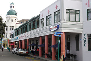
Napier is a city on the eastern coast of the North Island of New Zealand and the seat of the Hawke's Bay region. It is a beachside city with a seaport, known for its sunny climate, esplanade lined with Norfolk pines, and extensive Art Deco architecture. Napier is sometimes referred to as the "Nice of the Pacific", although that is largely outdated and a more common nickname is 'The Art Deco Capital of the world'.

<span class="mw-page-title-main">Dannevirke</span> Town in Manawatū-Whanganui, New Zealand

Dannevirke, is a rural service town in the Manawatū-Whanganui region of the North Island, New Zealand. It is the main centre of the Tararua District.

<span class="mw-page-title-main">Māhia Peninsula</span> Peninsula in Hawkes Bay, New Zealand

Māhia Peninsula is located on the east coast of New Zealand's North Island, in the Hawke's Bay region, between the towns of Wairoa and Gisborne.

<span class="mw-page-title-main">Pōrangahau</span> Settlement in Hawkes Bay Region, New Zealand

Pōrangahau, a township close to the Pacific Ocean coast in the south-east of the North Island of New Zealand, has a very small population. It lies in the southernmost part of Hawke's Bay, 45 kilometres south of Waipukurau, and close to the mouth of the Porangahau River. The settlement includes a marae and a school.

<span class="mw-page-title-main">Clive, New Zealand</span> Town in New Zealand

Clive is a small town, ten kilometres from the city centres of both Napier and Hastings in the Hawke's Bay region of New Zealand's North Island. It is close to the mouth of the Ngaruroro River.

<span class="mw-page-title-main">Napier Hill</span> Suburb of Napier, New Zealand

Napier Hill is a limestone outcrop and suburb rising above the lowland districts of the city of Napier on New Zealand's North Island.

Onekawa is a suburb of the city of Napier, in the Hawke's Bay Region of the eastern North Island of New Zealand. Development of the suburb began in the late 1940s, after the land was acquired from then-Harbour Board.

Maraenui is a suburb of the city of Napier, in the Hawke's Bay region of New Zealand's eastern North Island. The New Zealand Ministry for Culture and Heritage gives a translation of "great marae" for Maraenui.

Tutira is a village to the north of Napier and is part of the Hawke's Bay Region in New Zealand's North Island. It is located on State Highway 2 between Wairoa and Napier.

<span class="mw-page-title-main">Westshore, New Zealand</span> Suburb of Napier, New Zealand

Westshore is a northern coastal suburb of the city of Napier in Hawke's Bay, New Zealand.

Eskdale is a rural settlement in the Hastings District and Hawke's Bay region of New Zealand's North Island. It is located north of Napier on State Highway 5, near the mouth of the Esk River.

Omakere is a farming settlement in the Central Hawke's Bay District and Hawke's Bay Region of New Zealand's North Island. It is located east of Waipawa.

Pakowhai is a small settlement in the Hastings District and Hawke's Bay Region of New Zealand's North Island. It is a located between Napier and Hastings, north of the Ngaruroro River.

Marewa is a suburb of the city of Napier, in the Hawke's Bay Region of New Zealand's eastern North Island. Development of the suburb began in 1934, after the 1931 Hawke's Bay earthquake raised the previously low lying swamp land.

<span class="mw-page-title-main">Meeanee, New Zealand</span> Suburb of Napier, New Zealand

Meeanee is a locality south of the city of Napier, in the Hawke's Bay Region on the east coast of New Zealand's North Island. It was named after the Battle of Meeanee in India, won by Sir Charles Napier, the city's namesake. Along with such locations as Clive and Havelock North, it is one of several places within Hawke's Bay to be named after events or people in Colonial India.

<span class="mw-page-title-main">Poraiti</span> Suburb of Napier, New Zealand

Poraiti is a suburb on the western outskirts of the city of Napier, in the Hawke's Bay region of New Zealand's eastern North Island. For a long time it was a semi-rural locality on low hills, but has now been extended to include a new residential subdivision developed on the plain in the 2000s.

Camberley is a suburb of Hastings City, in the Hawke's Bay Region of New Zealand's North Island.

Mayfair is a suburb of Hastings City, in the Hawke's Bay Region of New Zealand's North Island.

<span class="mw-page-title-main">Maraekakaho</span> Settlement in Hawkes Bay Region, New Zealand

Maraekakaho is a rural settlement in the Hastings District and Hawke's Bay Region of New Zealand's North Island.

Sherenden is a settlement in the Hastings District and Hawke's Bay Region of New Zealand's North Island.

References

  1. 1 2 "ArcGIS Web Application". statsnz.maps.arcgis.com. Retrieved 17 February 2023.
  2. 1 2 "Population estimate tables - NZ.Stat". Statistics New Zealand . Retrieved 25 October 2023.
  3. NOTE: the term Ahuriri is also used as an alternative Māori language name for the city of Napier overall.
  4. "About > History". ahuriri.co.nz. Ahuriri Business Association. Archived from the original on 7 June 2019. Retrieved 7 June 2019.
  5. 1 2 "Statistical area 1 dataset for 2018 Census". Statistics New Zealand. March 2020. Ahuriri (212900). 2018 Census place summary: Ahuriri
  6. "Official School Website". portahuriri.school.nz.
  7. "Ministry of Education School Profile". educationcounts.govt.nz. Ministry of Education.
  8. "New Zealand Schools Directory". New Zealand Ministry of Education. Retrieved 14 March 2024.
  9. "Education Review Office Report". ero.govt.nz. Education Review Office.
  10. "Port Ahuriri School Centennial Celebrations 1868-1968". Knowledge Bank. Retrieved 17 February 2023.