Meeanee, New Zealand

Last updated

Meeanee
Suburb of Napier
St Marys Church, Taradale. Now a restaurant called The Church, Meeanee.JPG
St. Mary's Church, Meeanee.
Meeanee, New Zealand
Coordinates: 39°32′38″S176°53′35″E / 39.544°S 176.893°E / -39.544; 176.893 Coordinates: 39°32′38″S176°53′35″E / 39.544°S 176.893°E / -39.544; 176.893
Country New Zealand
Region Hawke's Bay
Territorial authority Napier City
WardTaradale
Named for Battle of Meeanee [1]
Electorate Napier
Government
  Territorial Authority Napier City Council
  Regional council Hawke's Bay Regional Council
Area
[2]
  Total24.30 km2 (9.38 sq mi)
Elevation
0–3 m (0–10 ft)
Population
 (June 2022) [3]
  Total3,220
  Density130/km2 (340/sq mi)
Time zone UTC+12 (NZST)
  Summer (DST) UTC+13 (NZDT)
Postcode
4112
Area Code06

Meeanee is a locality south of the city of Napier, in the Hawke's Bay Region on the east coast of New Zealand's North Island. It was named after the Battle of Meeanee in India (now spelled Miani, but the area has retained the older spelling), won by Sir Charles Napier, the city's namesake. [1] Along with such locations as Clive and Havelock North, it is one of several places within Hawke's Bay to be named after events or people in Colonial India.

Contents

History

Meeanee was the only access inland to Taradale until the road was built in 1873, and was the site of a Catholic Marist mission station from the 1850s. [4] The priests introduced viticulture to the Hawke's Bay region, planting several vineyards and establishing the Mission Estate Winery in 1851, New Zealand's oldest surviving winemaking concern. [5] They also built St Mary's Church in 1863, which still stands but is now a privately owned restaurant and event venue. [6]

Economy

Meeanee is located on the flat coastal plain south of Napier, and surrounded by farmland and apple orchards.

Demographics

The statistical area of Meeanee-Awatoto, which includes Awatoto, covers 24.30 km2 (9.38 sq mi) [2] and had an estimated population of 3,220 as of June 2022, [3] with a population density of 133 people per km2.

Historical population for Meeanee-Awatoto
YearPop.±% p.a.
20061,494    
20131,932+3.74%
20182,541+5.63%
Source: [7]
Apple orchard in Meeanee, Napier RK 1301 4472 Apfelplantage Napier.jpg
Apple orchard in Meeanee, Napier

Meeanee-Awatoto had a population of 2,541 at the 2018 New Zealand census, an increase of 609 people (31.5%) since the 2013 census, and an increase of 1,047 people (70.1%) since the 2006 census. There were 891 households, comprising 1,293 males and 1,248 females, giving a sex ratio of 1.04 males per female. The median age was 43.7 years (compared with 37.4 years nationally), with 471 people (18.5%) aged under 15 years, 399 (15.7%) aged 15 to 29, 1,221 (48.1%) aged 30 to 64, and 444 (17.5%) aged 65 or older.

Ethnicities were 87.5% European/Pākehā, 14.4% Māori, 3.1% Pacific peoples, 4.5% Asian, and 2.6% other ethnicities. People may identify with more than one ethnicity.

The percentage of people born overseas was 15.0, compared with 27.1% nationally.

Although some people chose not to answer the census's question about religious affiliation, 53.4% had no religion, 35.3% were Christian, 0.8% had Māori religious beliefs, 0.5% were Hindu, 0.1% were Muslim, 0.2% were Buddhist and 2.6% had other religions.

Of those at least 15 years old, 381 (18.4%) people had a bachelor's or higher degree, and 327 (15.8%) people had no formal qualifications. The median income was $37,400, compared with $31,800 nationally. 426 people (20.6%) earned over $70,000 compared to 17.2% nationally. The employment status of those at least 15 was that 1,137 (54.9%) people were employed full-time, 309 (14.9%) were part-time, and 60 (2.9%) were unemployed. [7]

Education

Meeanee School is a co-educational Year 1-8 state primary school, [8] with a roll of 107 as of February 2023. [9] [10] The school opened in 1865. [11]

Related Research Articles

<span class="mw-page-title-main">Napier, New Zealand</span> City in Hawkes Bay, New Zealand

Napier is a city on the eastern coast of the North Island of New Zealand and the seat of the Hawke's Bay region. It is a beachside city with a seaport, known for its sunny climate, esplanade lined with Norfolk Pines and extensive Art Deco architecture. Napier is sometimes referred to as the "Nice of the Pacific".

<span class="mw-page-title-main">Takapau</span> Settlement in Hawkes Bay Region, New Zealand

Takapau is a small rural community in the Central Hawkes Bay in New Zealand. It is located 20 kilometres west of Waipukurau, off State Highway 2, and has a population of more than 500.

<span class="mw-page-title-main">Tikokino</span> Settlement in Hawkes Bay Region, New Zealand

Tikokino is a town in the Central Hawke's Bay District on the east coast of the North Island of New Zealand. It is located 20 kilometres (12 mi) northwest of Waipawa and 55 kilometres (34 mi) southwest of Hastings. The township is located on State Highway 50.

<span class="mw-page-title-main">Clive, New Zealand</span> Town in New Zealand

Clive is a small town, ten kilometres from the city centres of both Napier and Hastings in the Hawke's Bay region of New Zealand's North Island. It is close to the mouth of the Ngaruroro River.

<span class="mw-page-title-main">Taradale, New Zealand</span> Suburb of Napier, New Zealand

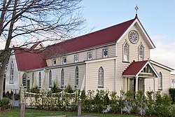
Taradale is a suburb of the City of Napier, in the Hawke's Bay Region of the North Island of New Zealand. It is a predominantly middle-upper class residential suburb, located 10 kilometres southwest of the centre of Napier. The Taradale ward, which includes Greenmeadows, Meeanee, and Poraiti, had a population of 22,809 in the 2018 New Zealand census.

<span class="mw-page-title-main">Napier Hill</span> Suburb of Napier, New Zealand

Napier Hill is a limestone outcrop and suburb rising above the lowland districts of the city of Napier on New Zealand's North Island.

Ōtāne is a town in the Central Hawke's Bay District and the Hawke's Bay region, on the east coast of New Zealand's North Island. The small village, has a school, general store, cafe and pub, and is located just off State Highway 2.

Onekawa is a suburb of the city of Napier, in the Hawke's Bay Region of the eastern North Island of New Zealand. Development of the suburb began in the late 1940s, after the land was acquired from then-Harbour Board.

Maraenui is a suburb of the city of Napier, in the Hawke's Bay region of New Zealand's eastern North Island. The New Zealand Ministry for Culture and Heritage gives a translation of "great marae" for Maraenui.

Tutira is a village to the north of Napier and is part of the Hawke's Bay Region in New Zealand's North Island. It is located on State Highway 2 between Wairoa and Napier.

<span class="mw-page-title-main">Ahuriri</span> Suburb of Napier, New Zealand

Ahuriri is a suburb of the city of Napier, in the Hawke's Bay region of New Zealand's eastern North Island.

<span class="mw-page-title-main">Westshore, New Zealand</span> Suburb of Napier, New Zealand

Westshore is a northern coastal suburb of the city of Napier in Hawke's Bay, New Zealand.

<span class="mw-page-title-main">Ongaonga, New Zealand</span> Settlement in Hawkes Bay Region, New Zealand

Ongaonga is a village in Central Hawkes Bay District of New Zealand's North Island. It is located 20 kilometres west of Waipawa and a similar distance from Waipukurau.

Eskdale is a rural settlement in the Hastings District and Hawke's Bay region of New Zealand's North Island. It is located north of Napier on State Highway 5, near the mouth of the Esk River.

<span class="mw-page-title-main">Tuai</span> Settlement in Hawkes Bay Region, New Zealand

Tuai is a village and rural community located around Lake Whakamarino, in the Wairoa District of the Hawke's Bay Region, on New Zealand's North Island.

Omakere is a farming settlement in the Central Hawke's Bay District and Hawke's Bay Region of New Zealand's North Island. It is located east of Waipawa.

Pakowhai is a small settlement in the Hastings District and Hawke's Bay Region of New Zealand's North Island. It is a located between Napier and Hastings, north of the Ngaruroro River.

Tamatea is a suburb in the west of the city of Napier, in the Hawke's Bay Region of New Zealand's eastern North Island.

Marewa is a suburb of the city of Napier, in the Hawke's Bay Region of New Zealand's eastern North Island. Development of the suburb began in 1934, after the 1931 Hawke's Bay earthquake raised the previously low lying swamp land.

<span class="mw-page-title-main">Poraiti</span> Suburb of Napier, New Zealand

Poraiti is a semi-rural suburb of the city of Napier, in the Hawke's Bay region of New Zealand's eastern North Island.

References

  1. 1 2 "St Thomas' Anglican Church". Heritage New Zealand . Retrieved 8 December 2019.
  2. 1 2 "ArcGIS Web Application". statsnz.maps.arcgis.com. Retrieved 24 February 2023.
  3. 1 2 "Population estimate tables - NZ.Stat". Statistics New Zealand . Retrieved 25 October 2022.
  4. Pollock, Kerryn. "Catholic mission station, Meeanee, 1850s". Te Ara - The Encyclopedia of New Zealand . Ministry for Culture and Heritage . Retrieved 8 December 2019.
  5. Dalley, Bronwyn (24 November 2008). "Wine – Page 1. 19th-century origins". Te Ara - The Encyclopedia of New Zealand. Ministry for Culture and Heritage. Retrieved 8 December 2019.
  6. "St Mary's Church". Heritage New Zealand. Retrieved 8 December 2019.
  7. 1 2 "Statistical area 1 dataset for 2018 Census". Statistics New Zealand. March 2020. Meeanee-Awatoto (215400). 2018 Census place summary: Meeanee-Awatoto
  8. "Meeanee School Ministry of Education School Profile". educationcounts.govt.nz. Ministry of Education.
  9. "New Zealand Schools Directory". New Zealand Ministry of Education. Retrieved 12 December 2022.
  10. "Meeanee School Education Review Office Report". ero.govt.nz. Education Review Office.
  11. "Meeanee School 130th jubilee : 20, 21 & 22 October : 1865 - 1995". Auckland Museum. Retrieved 24 February 2023.