Al Bowereh

Last updated

Al Bowereh or Al-Bweireh, also known as Aqabat Injeleh, [1] is a Palestinian village located just east of Hebron. It is situated adjacent to and north of the Israeli settlement of Givat Harsina. The village is occupied by Israel since 1967, together with the rest of the West Bank.

Contents

Geography

Al Bowereh is located at the northern edge of the Baqa'a Valley, a few kilometers east of Hebron City. It is sandwiched between the Israeli settlement Givat Harsina in the south and Israeli outposts in the north and the east. East of Al Bowereh runs the Israeli bypass road Route 60.

Population

According to the PCBS, the estimated population of Al Bowereh was about 780 in 2011, [1] but Christian Peacemaker Teams (CPT) mentioned a number of 340 people in 2012, [2] while ARIJ gave a number of 180 in 2009. [3] The existence of Al Bowereh is endangered due to on-going settlement expansion and demolition orders for almost all of the remaining homes in Al Bowereh. [2] Al Bowereh is owned by all members of the neighbourhood. [2]

Influence of the Israeli occupation

Israeli settlement and outpost expansion

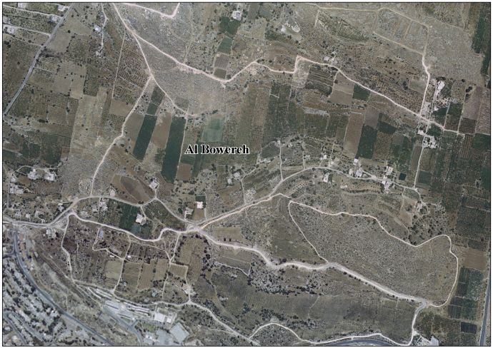
In 1985, Israeli settlers started the building of Givat Harsina between Al Bowereh and Kiryat Arba, on Palestinian lands belonging to the members of the Jaber and Al Bakri clans from Hebron. [4] In 1995, the Israeli bypass road 60 was built through the Palestinian farm lands located east of Harsina. [4]

In 2009, settlers started building the outpost "Hill 18", also named "Hill 26", "Mitzpe Avihai", "Karmei Netanel" and "Hammer Lot", between the settlement of Givat Harsina and Al Bowereh. [5] The Hill 18 outpost has a number of times been built, evacuated and rebuilt. [6] [7] Hill 26 is built on land belonging to the Palestinian Ja'abar family, expropriated by the Israeli government. The outpost was earlier dismantled in 1999. In the meantime, however, it had been consistently inhabited by settlers and protected by the IDF. [8] The area was declared a "closed military zone", forcing peace activists of Ta'ayush to evacuate. [8] Hill 26 is mentioned in the 2005 Sasson Report. It is located 230 meter from Givat Harsina and 1.6 kilometer from Kiryat Arba and borders Al Bowereh to the south. [9]

Outpost names can be confusing, as an outpost can have different names. An outpost that has been dismantled can be rebuilt under another name.

Settlers' violence

School girls in
Al Bowereh 2012.02.05.AbuWeire.4.JPG
School girls in
Al Bowereh

Settlers and the military have blocked the village road to Hebron for vehicles. A settler bypass road of the outpost Hill 18 runs parallel to the road. [10] Residents using the village are subjected to settlers' violence, and the children, who are forced to go to school by foot, are often attacked on their way to school. Since November 2009, Christian Peacemaker Teams has provided a protective presence in the area. As of 2012, CPT accompanied 174 children of Al Bowereh on their way home from school, to protect them from settlers' violence. [2]

Denied access to roads and land


Roadblocks prevent the residents from accessing their homes by car, forcing them to walk as far as three kilometers every time they leave or return to the neighborhood. Merchants and ambulances are forced to use long dirty roads. [2]

In 1982, the village tried to build on what now is referred to as Hilltop 26, but were stopped by the Israeli military. In 1986, the Israeli High Court ruled that the members of Al Bowereh were the owners of the land. After the death of an Israeli, however, an Israeli military court declared the lands "state land", without hearing the Al Bowereh residents. [2]

Related Research Articles

Hilltop, outpost or lot 26, was an illegal outpost, consisting of a mobile home, founded by Netanel Ozeri outside Hebron in the West Bank. It lay approximately 100 metres (330 ft) from the Kiryat Arba settlement, in the Beqa'a valley. At the time of its destruction. Despite court orders, he kept expanding his outpost, refused to bullet-proof the caravan, fence the area he claimed in, or accept protection from the IDF.

<span class="mw-page-title-main">Efrat (Israeli settlement)</span> Israeli settlement in the West Bank

Efrat, or previously officially Efrata, is an Israeli settlement in the West Bank, established in 1983 in the Judean Mountains. Efrat is located 12 kilometers (7.5 mi) south of Jerusalem, between Bethlehem and Hebron, 6.5 km (4 mi) east of the Green Line, at the Palestinian side of the West Bank wall. The settlement stands at an altitude of up to 960 metres above sea level and covers about 6,000 dunam. The international community considers Israeli settlements in the West Bank illegal under international law, but the Israeli government disputes this.

<span class="mw-page-title-main">Ma'on, Har Hevron</span> Israeli settlement in the West Bank

Ma'on is an Israeli settlement organized as a moshav shitufi in the West Bank. Located in the Judean Hills south of Hebron and north of Beersheba, it falls under the jurisdiction of Har Hevron Regional Council. In 2021, it had a population of 592.

<span class="mw-page-title-main">Beit El</span> Israeli settlement in the West Bank

Beit El or Beth El is an Israeli settlement and local council located in the Binyamin Region of the West Bank. The Orthodox Jewish town was settled in 1977–78 by the ultranationalist group Gush Emunim. It is located in the hills north of Jerusalem, east of the Palestinian city of al-Bireh, adjacent to Ramallah. In September 1997, Beit El was awarded local council status. The head of the local council is Shai Alon. In 2021 its population was 5,681. Its current population is 6,500 residents.

Mitzpe Kramim is an Israeli outpost in the West Bank. Located on a mountain ridge overlooking the Jordan Valley, it falls under the jurisdiction of the Mateh Binyamin Regional Council. It is built, as ruled by the Israeli Supreme Court on 25 August 2020, on private lands owned by residents of the Palestinian village of Deir Jarir. The international community considers any Israeli settlements in the West Bank illegal under international law, but the Israeli government disputes this.

<span class="mw-page-title-main">Beit Ummar</span> Municipality type B in Hebron, State of Palestine

Beit Ummar is a Palestinian town located eleven kilometers northwest of Hebron in the Hebron Governorate of the State of Palestine. According to the Palestinian Central Bureau of Statistics, in 2016, the town had a population of 17,892 inhabitants. Over 4,800 residents of the town are under the age of 18. Since the Second Intifada, unemployment ranges between 60 and 80 percent due mostly to the inability of residents to work in Israel and a depression in the Palestinian economy. A part of the city straddles Road 60 and due to this, several propositions of house demolition have occurred.

<span class="mw-page-title-main">Aqraba, Nablus</span> Palestinian town in the Nablus Governorate

Aqraba is a Palestinian town in the Nablus Governorate, located eighteen kilometers southeast of Nablus in the northern West Bank. According to the Palestinian Central Bureau of Statistics (PCBS), Aqraba had a population of approximately 8,180 inhabitants in 2007.

Avigayil or Abigail is an Israeli outpost in the West Bank. It lies between the settlements of Ma'on and Susya in the Southern Hebron Hills. The outpost is situated east of the Israeli West Bank barrier, 4.7 km kilometers from the Green line on what is officially known as Hilltop 850. Established in October 2001, Avigayil has a population of roughly 50, consisting of 30 families as of 2014, up from 17 registered in 2010, and is within the municipal jurisdiction of the Har Hebron Regional Council.

<span class="mw-page-title-main">Burin, Nablus</span> Municipality type C in Nablus, State of Palestine

Burin is a Palestinian village in the Nablus Governorate of the State of Palestine, in the northern West Bank, located 7 kilometres (4.3 mi) southwest of Nablus. The town had a population of around 2,800 in 2008.

<span class="mw-page-title-main">Giv'at Asaf</span> Place

Giv'at Asaf is an Israeli outpost in the West Bank. Located 3.5 kilometres (2.2 mi) from the settlement of Beit El, it falls under the jurisdiction of the Mateh Binyamin Regional Council. It has about 30 structures and is home to some 30 families. It was established in May 2001 after the murder of Asaf Hershkovitz, a resident of Ofra, for whom it was named. The international community considers Israeli settlements in the West Bank illegal under international law, whereas Israeli outposts are considered illegal both under international law as well as under Israeli law. According to the 2005 Sasson Report, Giv'at Asaf was built on privately owned Palestinian land, and is therefore also illegal under Israeli law.

Mitzpe Yair is an unauthorized Israeli settlement in the West Bank. Located two kilometres south-east of Susya, it falls under the jurisdiction of Har Hebron Regional Council. It consists of 15 prefabricated structures, and is home for several families.

<span class="mw-page-title-main">Community Peacemaker Teams</span> International pacifist and humanitarian organization

Community Peacemaker Teams or CPT is an international organization set up to support teams of peace workers in conflict areas around the world. The organization uses these teams to achieve its aims of lower levels of violence, nonviolent direct action, human rights documentation and nonviolence training in direct action. CPT sums up their work as being "committed to reducing violence by 'getting in the way'".

<span class="mw-page-title-main">At-Tuwani</span> Place in Hebron, Palestine

Tawani or at-Tuwani is a small Palestinian village in the south Hebron Hills of the Hebron Governorate. Many of the village's residents live in caves. The village is located south-east of the village of Yatta. Approximately one kilometre away lies Tel Tuwani, near the Israeli settlement of Ma’on. Frequent disputes occur between at-Tawani's residents and settlers over land, roads and water resources.

<span class="mw-page-title-main">Jalud</span> Municipality type D in Nablus, State of Palestine

Jalud is a Palestinian village in the Nablus Governorate in the northern West Bank. It is approximately 30 kilometers (19 mi) south of Nablus and is situated just east of Qaryut, south of Qusra and northeast of Shilo, an Israeli settlement. Its land area consists of 16,517 dunams, 98 of which constitutes its built-up area. Jalud is encircled by four illegal outposts: Esh Kodesh, Adi Ad, Ahiya and Shvut Rachel. Jalud residents were blocked by both IDF forces and settlers from tending most of their farms from 2001 to 2007. In 2007 permission was given to farm their groves, twice a year for a few days, on condition that prior coordinating arrangements are made with the IDF.

<span class="mw-page-title-main">Masafer Yatta</span> Palestinian villages south of Hebron, West Bank

Masafer Yatta is a collection of 19 Palestinian hamlets in the southern West Bank, in the Hebron Governorate of the State of Palestine, located between 14 and 24 kilometers south of the city of Hebron, in the southern Hebron Hills. The hamlets are situated within the municipal boundary of Yatta. The name "Masafer" is believed to derive from the Arabic words for "traveling," in light of the distance needed to travel from Yatta, or "nothing" in light of the local belief that "nothing" would be able to live in the area.

<span class="mw-page-title-main">Worshippers Way</span>

Worshippers Way or Prayers Road in Hebron, West Bank is a road linking the Israeli settlement of Kiryat Arba with the Cave of the Patriarchs and with the Jewish settlements in Hebron. The road is used by Israelis and tourists who visit the Cave and the Old City of Hebron. Palestinians are denied vehicular use of the road. The road was expanded after an ambush near Kiryat Arba that took place in November 2002. The expansion required that adjacent Palestinian land be expropriated, which resulted in a legal battle. A number of buildings of architectural and historical value, dating back to the Mamluk-Ottoman period, were also expropriated and destroyed.

Al Baqa or Al Baqa'a, also spelled Al-Beqa or Al baqr, is a Palestinian village located just east of Hebron. It has been occupied by Israel since 1967, together with the rest of the West Bank. It is sandwiched between the Israeli settlements Givat Harsina and Kiryat Arba. Wadi al-Ghrous or Wadi al Gruz is a locality of Hebron that borders Al Baqa on the west.

The Baqa'a Valley, sometimes called Beqa'a Valley, is a fertile agricultural Palestinian area in the West Bank, just east of Hebron. Located in the area are the Palestinian villages Al Bowereh, Al Baqa and Wadi al-Ghrous. The Israeli settlement Givat Harsina abuts on the northern outskirts; Kiryat Arba borders the south. The Valley is occupied by Israel since 1967. Apart from the Israeli settlers, the area is mainly populated by members of the Jaber clan.

<span class="mw-page-title-main">Wadi al-Hussein</span>

Wadi al Hussein, sometimes referred to as 'Wadi Nasara, is a wadi east of and adjacent to the city of Hebron. The valley connects the Kiryat Arba settlement with the Israeli-controlled H2 area of Hebron's old city. The borders of the valley are Othman Bin Afan Street, also known as Zion Street or Worshipers' Way in the west; Wadi Al Nassara in the north; the Kiryat Arba fence in the east; Wadi Al Ghrous and the road connecting Kiryat Arba with Zion Street in the south.

Umm al-Khair is a Palestinian village located in the Hebron Governorate of the southern West Bank. It is inhabited by five families, roughly 70 people.

References

  1. 1 2 Hebron Governorate Statistical Yearbook No. 3, tab. 4, p. 65. PCBS, 2011
  2. 1 2 3 4 5 6 Al Bowereh West bank, palestine Archived 2015-09-23 at the Wayback Machine . Christian Peacemaker Teams, February 2012 (size: 6.1 MB). on: ;
  3. Al Bowereh Village—Fact Sheet. ARIJ, 2009
  4. 1 2 The Colony of Kharsina Expands on the Expense of the City of Hebron. POICA, 3 December 2008
  5. Police evacuate 2 huts, tent in West Bank. Efrat Weiss, YnetNews, 16 June 2009
  6. Mitzpe Avihai outpost evacuated again. Efrat Weiss, YnetNews, 16 June 2009
  7. See also Al Bowereh, Hill 18 and Givat Harsina on Google Maps, marked in color
  8. 1 2 Birth of a settlement. Mairav Zonszein and Joseph Dana, Haaretz, 22 May 2009
  9. PeaceNow, Hill 26 (Karmei Netanel) Archived 2014-09-11 at the Wayback Machine Accessed June 2014. Hill 26 on the map: Al Bowereh West bank, palestine Archived 2015-09-23 at the Wayback Machine , p. 11.
  10. Al-Bweireh, Hebron District: the roads on the map. CPT/Dove, AtTuwani Project. 24 March 2011