
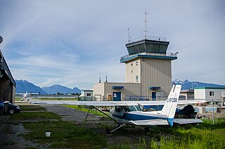
Boundary Bay Airport or Vancouver/Boundary Bay Airport is located beside Boundary Bay and 2.5 nautical miles east of Ladner in Delta, British Columbia, Canada, 8.5 NM south southeast of Vancouver and close to the Canada-U.S. border. The airport, which opened July 11, 1983, serves mostly general aviation and includes facilities for aircraft maintenance, flight training, parking, and air traffic control training. Boundary Bay is Canada's fifth busiest airport by total aircraft movements, and the country's busiest general aviation airport. It is the location of the former Canadian Forces Station Ladner.

Alert Airport is located at Alert, Nunavut, Canada, approximately 830 km (520 mi) south of the true North Pole. It is operated by the Canadian Department of National Defence and is part of Canadian Forces Station Alert. A weather station was established on the site in 1950, and in 1957 construction began on the military facilities which are still in use to this day. It is the northernmost airport in the world.

Arctic Bay Airport,, is an airport located 3 nautical miles southeast of Arctic Bay, Nunavut, Canada. Until January 12, 2010 Nanisivik Airport, about 25 km (16 mi) from Arctic Bay, was used for scheduled flights. On January 13, 2010, First Air transferred all air services to Arctic Bay's newly expanded airport with service to Iqaluit and Resolute Bay. Niore Iqalukjuak, mayor of Arctic Bay, said that the move would save community members $40.00 for the one way taxi ride. At the same time the Government of Nunavut said that the move would save $600,000 a year because of not having to keep the all-weather road clear.

Akulivik Airport is located 1.5 nautical miles southwest of Akulivik, Quebec, Canada.
Pitt Meadows Airport is a Canadian general aviation airport located in the southwest of corner of Pitt Meadows, British Columbia. In 2018, it was the 17th busiest airport in Canada with 117,983 aircraft movements and is the 4th busiest airport in the Lower Mainland.

Algoma Mills Water Aerodrome,, is located on Lauzon Bay, Ontario, Canada and serves the community of Algoma Mills.
Alliston Airport,, is located 1.3 nautical miles northeast of Alliston, Ontario, Canada.

Gore Bay-Manitoulin Airport,, is located 5 nautical miles west southwest of Gore Bay, in the township of Gordon/Barrie Island, Ontario, Canada.
Pelee Island Airport is located adjacent to the west side of Pelee, Ontario, Canada. Approximately 5,500 passengers passed through Pelee Island Airport in 2009.

Bow Island Airport,, is located 1 nautical mile northeast of Bow Island, Alberta, Canada.

Alert Bay Water Aerodrome,, is located adjacent to Alert Bay, British Columbia, Canada. The water aerodrome is built on Cormorant Island in the Queen Charlotte Strait, between Malcolm Island and Port McNeill.
Alliford Bay Water Aerodrome,, is located on Alliford Bay, British Columbia, Canada. Alliford Bay is a part of Skidegate Inlet, Moresby Island in the Haida Gwaii Islands.
Big Bay Water Aerodrome,, is located adjacent to Big Bay, British Columbia, Canada. Big Bay lies on Stuart Island in the Discovery Islands.
Mayne Island Water Aerodrome, formerly IATA: YAV, TC LID: CAW7, is a defunct aerodrome that was located at Miners Bay adjacent to Mayne Island in British Columbia, Canada. Mayne Island is one of the southern Gulf Islands.

Mould Bay Airport(IATA: YMD, ICAO: CYMD) was located on the Prince Patrick Island, Northwest Territories, Canada. It was built in 1948 as a joint effort between Canada and the United States to service the former Environment Canada weather station. The station was automated in 1997 which eliminated the need for an airport; however, the island is still occasionally visited by members of the Canadian Forces.
