Bonneville Lock and Dam consists of several run-of-the-river dam structures that together complete a span of the Columbia River between the U.S. states of Oregon and Washington at River Mile 146.1. The dam is located 40 miles (64 km) east of Portland, Oregon, in the Columbia River Gorge. The primary functions of Bonneville Lock and Dam are electrical power generation and river navigation. The dam was built and is managed by the United States Army Corps of Engineers. At the time of its construction in the 1930s it was the largest water impoundment project of its type in the nation, able to withstand flooding on an unprecedented scale. Electrical power generated at Bonneville is distributed by the Bonneville Power Administration. Bonneville Dam is named for Army Capt. Benjamin Bonneville, an early explorer credited with charting much of the Oregon Trail. The Bonneville Dam Historic District was designated a National Historic Landmark District in 1987.

Wheeler Dam is a hydroelectric dam on the Tennessee River between Lauderdale County and Lawrence County in Alabama. It is one of nine dams on the river owned and operated by the Tennessee Valley Authority, which built the dam in the mid-1930s as part of a New Deal-era initiative to improve navigation on the river and bring flood control and economic development to the region. The dam impounds the Wheeler Lake of 67,070 acres (27,140 ha) and its tailwaters feed into Wilson Lake.

The Chickamauga Dam is a hydroelectric dam on the Tennessee River in Chattanooga, Tennessee, United States. The dam is owned and operated by the Tennessee Valley Authority, which built the dam in the late 1930s as part of a New Deal era initiative to improve navigation and bring flood control and economic development to the Tennessee Valley. The dam impounds the 36,240-acre (14,670 ha) Chickamauga Lake and feeds into Nickajack Lake. The dam and associated infrastructure were listed on the National Register of Historic Places in 2017.

Lock and Dam No. 15 is a lock and dam located on the Upper Mississippi River. It spans the river between Rock Island, Illinois and Davenport, Iowa. Lock and Dam 15 is the largest roller dam in the world, its dam is 1,203 feet (366.7 m) long and consists of nine 109 feet (33.2 m) non-submersible, non-overflow roller gates and two 109 feet (33.2 m) non-submersible overflow roller gates. It is unusual among the upper Mississippi River dams in that it has only roller gates, has different sizes and types of roller gates, it is not perpendicular to the flow of the river and is one of the few facilities that has a completed auxiliary lock. The main lock is 110 feet (33.5 m) wide by 600 feet (180 m) long and its auxiliary lock is 110 feet (34 m) wide by 360 feet (110 m) long. In 2004, the facility was listed in the National Register of Historic Places as Lock and Dam No. 15 Historic District, #04000175 covering 3,590 acres (1,450 ha), 2 buildings, 9 structures, and 1 object.

The Lehigh Canal is a navigable canal that begins at the mouth of Nesquehoning Creek on the Lehigh River in the Lehigh Valley and Northeastern regions of Pennsylvania. It was built in two sections over a span of 20 years beginning in 1818. The lower section spanned the distance between Easton and present-day Jim Thorpe. In Easton, the canal met the Delaware and Morris Canals, which allowed anthracite coal and other goods to be transported further up the U.S. East Coast. At its height, the Lehigh Canal was 72 miles (116 km) long.
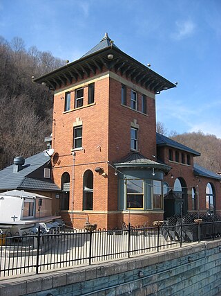
The Merrill Lock No. 6 is the remnant of a historic lock and dam complex located along the Ohio River at Industry, Pennsylvania, United States. The remaining buildings, which now compose a restaurant, are together listed on the National Register of Historic Places.

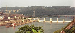
The Allegheny River Lock and Dam No. 2 in Pittsburgh, Pennsylvania is a lock and fixed-crest dam from 1932. It crosses the Allegheny River between the Pittsburgh neighborhood of Highland Park and the suburb of Aspinwall. The lock and dam were built by the U.S. Army Corps of Engineers as a part of an extensive system of locks and dams to improve navigation along the Allegheny River. It is the most-used lock operated by the United States Army Corps of Engineers.
Braddock Locks & Dam is one of nine navigational structures on the Monongahela River between Pittsburgh, Pennsylvania and Fairmont, West Virginia. Built and maintained by the U.S. Army Corps of Engineers, the gated dam and the lock form an upstream pool that is for 12.6 miles (20.3 km), stretching to Elizabeth, Pennsylvania.

Starved Rock Lock and Dam, also known as Lock and Dam No. 6, is a lock and dam facility managed by the U.S. Army Corps of Engineers along the Illinois River. It is part of the Illinois Waterway and was constructed between 1926 and 1933. The lock and dam was added to the National Register of Historic Places as the Starved Rock Lock and Dam Historic District in 2004.

C.W. Bill Young Lock and Dam in Harmar Township, Allegheny County, Pennsylvania, and Plum, Pennsylvania, is a lock that was built in 1932. The lock and fixed-crest dam were built by the U.S. Army Corps of Engineers as a part of an extensive system of locks and dams to improve navigation along the Allegheny River.

The Allegheny River Lock and Dam No. 4 in Harrison Township, Allegheny County, Pennsylvania, is a lock that was built 1920-1927, and opened in 1927, 24.2 miles upstream from the mouth of the river in Pittsburgh. The lock and dam were built by the U.S. Army Corps of Engineers as a part of an extensive system of locks and dams to improve navigation along the Allegheny River.

The Davis Island Lock and Dam Site on the Ohio river in Avalon, Pennsylvania, is the site of the former Davis Island lock that was completed in 1885.

The Kaukauna Locks Historic District is a lock and dam system in Kaukauna, Wisconsin, United States, that carried boat traffic around a rapids of the Fox River starting in the 1850s as part of the Fox–Wisconsin Waterway. It was added to the National Register of Historic Places in 1993 for its significance in engineering and transport.

Allegheny River Lock and Dam No. 5 is a historic lock and fixed-crest dam complex located at Gilpin Township and South Buffalo Township in Armstrong County, Pennsylvania. It was built between 1920 and 1927 by the United States Army Corps of Engineers, and consists of the lock, dam, esplanade, and Operations Building. The lock measures 56 feet by 360 feet, and has a lift of 11.6 feet. The dam measures approximately 22 feet high and 632 feet long.
Allegheny River Lock and Dam No. 7 is a historic lock and fixed-crest dam complex located at East Franklin Township, Pennsylvania and Kittanning in Armstrong County, Pennsylvania. It was built between 1928 and 1930 by the United States Army Corps of Engineers, and consists of the lock, dam, esplanade, and Operations Building. The lock measures 56 feet by 360 feet, and has a lift of 13.0 feet. The dam measures approximately 20 feet high and 916 feet long. The Operations Building, or powerhouse, is a utilitarian two-story building in a vernacular early-20th century revival style. The lock and dam were built by the U.S. Army Corps of Engineers as a part of an extensive system of locks and dams to improve navigation along the Allegheny River.

Allegheny River Lock and Dam No. 8 is a historic lock and fixed-crest dam complex located at Boggs Township and Washington Township in Armstrong County, Pennsylvania. It was built between 1929 and 1931 by the United States Army Corps of Engineers, and consists of the lock, dam, esplanade, and Operations Building. The lock measures 56 feet by 360 feet, and has a lift of 17.8 feet. The dam measures approximately 50 feet high and 916 feet long; a three-foot addition was built on top of the dam in 1937. The Operations Building, or powerhouse, is a utilitarian two-story building in a vernacular early-20th century revival style. The lock and dam were built by the U.S. Army Corps of Engineers as a part of an extensive system of locks and dams to improve navigation along the Allegheny River.

Allegheny River Lock and Dam No. 9 is a historic lock and fixed-crest dam complex located at Madison Township and Washington Township in Armstrong County, Pennsylvania. It was built between 1935 and 1938 by the United States Army Corps of Engineers, and includes the lock, dam, steel miter gates, and Operations Building. The lock measures 56 feet by 360 feet, and has a lift of 22 feet. The dam measures approximately 60 feet high and 918 feet long. The Operations Building, or powerhouse, is a utilitarian two-story building in a vernacular early-20th century revival style. The lock and dam were built by the U.S. Army Corps of Engineers as a part of an extensive system of locks and dams to improve navigation along the Allegheny River.

LaGrange Lock and Dam is a lock and dam complex on the Illinois River at Versailles, Illinois. The structure includes a 1,066 feet (325 m) dam and a 110 by 600 feet lock. The U.S. Army Corps of Engineers built the complex from 1936 to 1939; A.F. Griffin designed the lock and dam, while Paul Le Gromwell designed the control station. The lock and dam, as well as a similar lock and dam near Peoria, were needed when the authorized channel depth was raised to nine foot. The Peoria and LaGrange locks replaced older locks on the lower Illinois River. The lock uses Chanoine wicket gates, which allow for navigation on the river, rather than the Tainter gates seen elsewhere on the river.

Emsworth Locks and Dam is a combination of locks and dam on the Ohio River located just downstream of Pittsburgh. The dam has two gated sections, one on each side of Neville Island. There are two locks, one for commercial barge traffic that is 600 feet long by 110 feet wide, and the recreational auxiliary lock that is 360 feet long by 56 feet wide. Emsworth averages about 470 commercial lock throughs every month and 350-400 lock throughs a month on the recreational auxiliary lock.