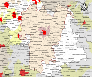
Ambel is located at the southern end of the department of Isère, in the Beaumont area, on a small plateau extending north of Faraud Mountain on the eastern edge of the Dévoluy massif between the Drac river which forms the north-eastern border and the Souloise river which forms the western border. The commune is some 20km south-west of La Mure and some 50km north by north-east of Veynes although is not directly accessible from the places. Access to the commune is by minor road D217 which branches from national route N85 at Le Motty to the east of the commune. The D217 goes west to the village then turn south to Monestier-d'Ambel.[3]
Ambel overlooks Lake Sautet which is formed by a dam located 1 kilometre north of the village, and dams the two rivers on two sides of the commune. The Plateau of Ambel is one of the residues of an ancient alluvial plain created by a glacial barrier which was at the location of the current dam and subsequently cut through by the Drac and Souloise.Corps to the east and Pellafol to the west are located on the lateral edges of the plain at the same altitude. This gives the local landscape a distinctive aspect with the three villages facing and partially embedded inside the gorge.[4]
Ambel takes its name from the Latin root amb- meaning "with two sides" which refers to the geographical position of the village on a promontory between the Souloise and the Drac valleys: Ambilis in Taraone in low-Latin, Hembel or Hembellum in the 15th century.[5]
History
There was a lordship with a castle at Ambel which existed at the end of the 8th century. Ardradus, son of Bysardon, had a son Eldrade (781-844?) who became a monk and gave up all his rights to Novalesa Abbey in Piedmont, Italy.
The Saracens destroyed everything in the early years of the 10th century. Ambel was part of the Comte de Provence but was liberated in the year 973, then was part of Forcalquier in 1054, then Dauphiné in 1209. When creating the Castellany in 1250, Ambel was part of Corps.[6]
The Lordship of Ambel, which was composed of the two parishes of Ambel and Monestier, was established on 11 March 1315, by dismantling the mandate of Corps in favour of Pierre of Ambel and "as needed" his brother Humbert. Peter had, by concession from the Dauphin, high, middle, and low jurisdiction rights over Ambel. The lordship was transmitted through four generations of the Ambel family until the death of Raymond III around 1445. His eldest son Stephen had died ten years earlier and Raymond left only daughters; the Salic law did not apply to dauphinoise land so the eldest, Burguette, became Lady Ambel and her husband, Raymond de la Villette was Lord "of his wife's head" until his death. In 1470 their two sons, John and Aymar de la Villette, become co-lords of Ambel on the death of their mother and sold the lordship to Jean de Bonne,[7] whose eldest son Peter in 1500 gave rights to his brother Reynaud over Monestier which then became a separate lordship.[6]
The lordship of Ambel, which was now reduced to a mere parish of Ambel, was sold by Pierre de Bonne to Guillaume of Vienne in 1504. The Viennese were Catholic. The Wars of religion raged in Ambel: the village was destroyed and the castle taken and retaken five times between 1562 and 1577. In 1578, Lesdiguières besieged Ambel; Bertrand III Raimbault de Simiane, Baron of Gordes,[8] dislodged him but Lesdiguières returned and took the castle again.[9] Pierre III of Poligny bought the lordship in Vienne in 1617 and resold it to Jean Achard around 1645. Antoine Achard, nephew and heir of Jean, emigrated in 1867 and his fief was confiscated and given to his younger son Judéon. Pierre Achard, the son of Judéon, passed it to his cousin and adopted son Richard Gautier. Marc-Richard, his son, was deposed by the French Revolution.[6]
In 1790 the commune was, like its neighbours, integrated into the department of Hautes-Alpes[10] then a few years later to the department of Isère in the Canton of Corps.
The building of the Sautet Dam in 1935 physically separated Ambel from Corps and Pellafol and this forced long detours to reach the neighbouring communes. A ferry link was attempted, but abandoned after a capsize.
The lords of the Ambel family
(Dates are not given as they are too uncertain)
Pierre, created Lord by the Dauphin in 1315 (Pierre I), and Humbert, his brother, Lord "as needed"
Raymond, son of Pierre I (Raymond I) and Pierre called Perret, his brother (Pierre II) co-Lords
Henri, son of Raymond I, and Raymond, his brother (Raymond II), co-Lords
Aymar, son of Henri, Lord, childless
Raymond, nephew of Henry and Raymond II (Raymond III), Lord, died without male issue in 1445 (date uncertain).[11]
During the wars of religion, a Stephen Ambel, Protestant, whose kinship with the previous Lords was not established, was briefly lord of Ambel.[12]
The succession of Raymond III
Raymond had five children but his only son, the eldest of the five, died before him. On his death the elder branch of Ambel was extinguished and the eldest daughter, Burguette, passed the lordship of Ambel to her children. The other three sisters, Clemence, Lantelme, and Catherine inherited the lands of high- Valgaudemar which entered the family by the marriage of their great-uncle Henri to Alix de Bonne. Clemence's land remained known as Clemence-d'Ambel until the middle of the 20th century. Those of Catherine passed to her daughter Marguerite whose husband Guillaume Pérouse bought Lantelme's share constituting the territory now known as Guillaume-Pérouse.[13]
Heraldry
Arms of Ambel
Blazon:
Or, a windmill of argent port and window sable with sails gules posed on a hillock vert.[14]
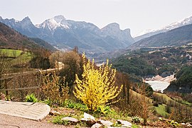
A view of Obiou from AmbelView of the interior of the church. On the left a statue of Saint-Eldrade
On the hill overlooking the village there is surmised to be the remains of the ancient castle.
A little further down is a small 19th-century church. In the forecourt is a view of the Dévoluy and Lake Sautet (the Souloise side) dominated by the Obiou.
Notable people
Saint Eldrade was born in 781 in Ambel, the son of Lord Aldradus, he chose to be a monk and became superior of Novalesa Abbey in Piedmont. An annual pilgrimage is held from Monestier-d'Ambel towards Ambel. Pilgrims come from the region and sometimes from Le Monêtier-les-Bains and Italy to commemorate the saint.
Jean Gueydan, The Lords of Beaumont, ed. du Cosmogone, 2003, ISBN2-914238-40-1(in French).
Related Research Articles
Grenoble is the prefecture and largest city of the Isère department in the Auvergne-Rhône-Alpes region of southeastern France. It was the capital of the Dauphiné historical province and lies where the river Drac flows into the Isère at the foot of the French Alps.
The Dauphiné is a former province in southeastern France, whose area roughly corresponded to that of the present departments of Isère, Drôme and Hautes-Alpes. The Dauphiné was originally the Dauphiné of Viennois.
Gap is the prefecture of the department of Hautes-Alpes, in the region of Provence-Alpes-Côte d'Azur, Southeastern France. In 2019, the commune had a population of 40,631, making it the most populated city in Hautes-Alpes. At a height of 750 metres above sea level, to the south of the Écrins Massif, it is also France's highest prefecture.
The Isère is a river in the Auvergne-Rhône-Alpes region of southeastern France. Its source, a glacier known as the Sources de l'Isère, lies in the Vanoise National Park in the Graian Alps of Savoie, near the ski resort in Val-d'Isère on the border with Italy. An important left-bank tributary of the Rhône, the Isère merges with it a few kilometers north of Valence.
Aubeterre-sur-Dronne, commonly referred to as Aubeterre, is a commune in the Charente department in the Nouvelle-Aquitaine region of Southwestern France.
Ambutrix is a commune in the Ain department in the Auvergne-Rhône-Alpes region of eastern France.
Castellane is a commune in the Alpes-de-Haute-Provence department in the Provence-Alpes-Côte d'Azur region in Southeastern France. With a population of 1,470 (2019), it has the distinction of being France's least populated subprefecture, ahead of Largentière in Ardèche.
The arrondissement of Grenoble is an arrondissement of France in the Isère department in the Auvergne-Rhône-Alpes region. It has 263 communes. Its population is 738,149 (2016), and its area is 4,398.7 km2 (1,698.3 sq mi).
Pellafol is a commune in the Isère department in southeastern France.
Allemagne-en-Provence is a commune in the Alpes-de-Haute-Provence department in the Provence-Alpes-Côte d'Azur region in southeastern France.
Corps is a commune in the department of Isère in southeastern France.
Canton of Matheysine-Trièves is a canton of the Isère département, in south-eastern part of France. It was created at the French canton reorganisation which came into effect in March 2015. The seat of the canton is in La Mure. It takes its name from the regions Matheysine and Trièves.
Beaufin is a commune in the Isère department in the Auvergne-Rhône-Alpes region of south-eastern France.
Avignonet is a commune in the Isère department in the Auvergne-Rhône-Alpes region of south-eastern France.
Ascros is a commune in the Alpes-Maritimes department in the Provence-Alpes-Côte d'Azur region of south-eastern France.
La Fare-en-Champsaur is a commune in the department of Hautes-Alpes in the Provence-Alpes-Côte d'Azur region in southeastern France.
Lus-la-Croix-Haute is a commune in the Drôme department in southeastern France.
Chapareillan is a commune in the Isère department and Auvergne-Rhône-Alpes region in southeastern France.
Victor Sappey, also known as Pierre-Victor Sappey, was a French sculptor.
Grenoble metropolitan area as defined by INSEE in 2020 is the functional urban area of the city of Grenoble, southeastern France. It covers 204 communes, all in the Isère department. It has 714,799 inhabitants (2018) in an area of 2,876 km2 (1,110 sq mi), which is 39% of the Isère department. Grenoble and 15 other communes form the pôle urbain or urban cluster, the other 188 communes form the couronne or commuter belt. The most populous communes in the functional area are Grenoble, Échirolles, Fontaine, Meylan, Le Pont-de-Claix, Saint-Égrève, Saint-Martin-d'Hères, Sassenage, Seyssinet-Pariset and Voiron, all except Voiron part of the pôle urbain. It is the 11th-most populous functional urban area in France.
↑ The distance as the crow flies is less than 2 km but it is necessary to travel 10 km by (bad) road to go from Ambel to Pellafol Ambel; to go to Corps, which is the capital of the canton, it is necessary to go through the Hautes-Alpes as the direct route has been drowned by the lake
↑ Jean Gueydan, The Lords of Beaumont, ed. Cosmogone, 2003, ISBN2-914238-40-1, p. 111 (in French).
1 2 3 Jean Gueydan, The Lords of Beaumont, ed. Cosmogone, 2003, ISBN2-914238-40-1, p. 111-113 (in French).
↑ François de Bonne, Duke of Lesdiguières, would a century later be a descendant of a cousin of this Jean.
↑ P. Fisson & Auguste Vitu, The Department of Isère, 1856, reprinted. Les éditions du Bastion, Grenoble, 2000 ISBN2-7455-0078-3, p. 290. (in French)
↑ See the map of Hautes-Alpes extracted from the National Atlas [Dumez, year II], reproduced in the book Men, land, a story ... Hautes-Alpes, published by CG05, under the direction of Patricia Guyard, December 2002 ( ISBN2-86005-009-4), page 113.
↑ Jean Gueydan, The Lords of Beaumont, ed. Cosmogone, 2003, ISBN2-914238-40-1, p. 112, 206-209 (in French).
↑ Jean Gueydan, The Lords of Beaumont, ed. Cosmogone, 2003, ISBN2-914238-40-1, p. 210 (in French).
↑ Jean Gueydan, The Lords of Beaumont, ed. Cosmogone, 2003, ISBN2-914238-40-1, p. 208-209 (in French).
This page is based on this Wikipedia article Text is available under the CC BY-SA 4.0 license; additional terms may apply. Images, videos and audio are available under their respective licenses.