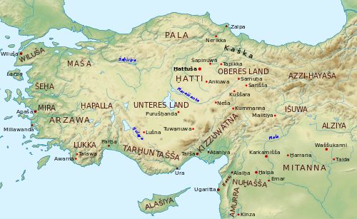
The following is a list of regions of Ancient Anatolia, also known as "Asia Minor." The names reflect changes to languages, settlements and polities from the Bronze Age to conquest by Turkic peoples.
Note: Over time the regions did not always were the same and had the same size or the same borders and sometimes included different subregions, districts, divisions or parts or were united with others.
The names of many regions ended in "e" [e] that was the Eastern Greek (Attic Ionic Ancient Greek) equivalent to the Western Greek (Doric Greek) "a" [a] and also to the Latin "a" [a]. In Ancient Greek the "ph" represented the consonants p [p] and h [h] pronounced closely and not the f [f] consonant. In Ancient Greek the "y" represented the vowel [y] (ü) and not the semivowel [j] or the vowels [i] or [I].
The Themata were combined Military and Administrative divisions of the Byzantine Empire (East Roman Empire) which replaced the Roman provincial system in the 7th-8th century and reached their height in the 9th and 10th centuries. [1]
Ducates or Catepanates (combined Military and Administrative divisions of the Byzantine Empire (East Roman Empire) on border regions that included smaller Themata under the command of a Dux or Katepano)
Anatolia, also known as Asia Minor, is a peninsula in West Asia that makes up the majority of the land area of Turkey. It is the westernmost protrusion of Asia and is geographically bounded by the Mediterranean Sea to the south, the Aegean Sea to the west, the Turkish Straits and the Sea of Marmara to the northwest, and the Black Sea to the north. The eastern and southeastern limits have been expanded either to the entirety of Asiatic Turkey or to an imprecise line from the Black Sea to the Gulf of Alexandretta. Topographically, the Sea of Marmara connects the Black Sea with the Aegean Sea through the Bosporus and the Dardanelles, and separates Anatolia from Thrace in Southeast Europe.
Galatia was an ancient area in the highlands of central Anatolia, roughly corresponding to the provinces of Ankara and Eskişehir, in modern Turkey. Galatia was named after the Gauls from Thrace, who settled here and became a small transient foreign tribe in the 3rd century BC, following the Gallic invasion of the Balkans in 279 BC. It has been called the "Gallia" of the East.
Cappadocia is a historical region in Central Anatolia region, Turkey. It is largely in the provinces of Nevşehir, Kayseri, Aksaray, Kırşehir, Sivas and Niğde.
Mysia was a region in the northwest of ancient Asia Minor. It was located on the south coast of the Sea of Marmara. It was bounded by Bithynia on the east, Phrygia on the southeast, Lydia on the south, Aeolis on the southwest, Troad on the west, and the Propontis on the north. In ancient times it was inhabited by the Mysians, Phrygians, Aeolian Greeks and other groups.
Paphlagonia was an ancient region on the Black Sea coast of north-central Anatolia, situated between Bithynia to the west and Pontus to the east, and separated from Phrygia by a prolongation to the east of the Bithynian Olympus. According to Strabo, the region was bounded by the river Parthenius to the west and the Halys River to the east. Paphlagonia was said to be named after Paphlagon, a son of the mythical Phineus.
The Troad or Troas is a historical region in northwestern Anatolia. It corresponds with the Biga Peninsula in the Çanakkale province of modern Turkey. Bounded by the Dardanelles to the northwest, by the Aegean Sea to the west and separated from the rest of Anatolia by the massif that forms Mount Ida, the Troad is drained by two main rivers, the Scamander (Karamenderes) and the Simois, which join at the area containing the ruins of Troy.
Lesser Armenia, also known as Armenia Minor and Armenia Inferior, comprised the Armenian-populated regions primarily to the west and northwest of the ancient Kingdom of Armenia, on the western side of the Euphrates River. It was also a kingdom, separate from Greater Armenia, from the 2nd century BC to the 1st century AD. The region was later reorganized into the Armeniac Theme under the Byzantine Empire.
Asia was a Roman province covering most of western Asia Minor (Anatolia), which was created following the Roman Republic's annexation of the Attalid Kingdom in 133 BC. After the establishment of the Roman Empire by Augustus, it was the most prestigious senatorial province and was governed by a proconsul. That arrangement endured until the province was subdivided in the fourth century AD.
Pisidia was a region of ancient Asia Minor located north of Pamphylia, northeast of Lycia, west of Isauria and Cilicia, and south of Phrygia, corresponding roughly to the modern-day province of Antalya in Turkey. Among Pisidia's settlements were Antioch in Pisidia, Termessos, Cremna, Sagalassos, Etenna, Neapolis, Selge, Tyriacum, Laodiceia Katakekaumene, Adada (Pisidia) and Philomelium.
Lycaonia was a large region in the interior of Asia Minor, north of the Taurus Mountains. It was bounded on the east by Cappadocia, on the north by Galatia, on the west by Phrygia and Pisidia, while to the south it extended to the chain of Mount Taurus, where it bordered on the country popularly called in earlier times Cilicia and in the Byzantine period Isauria; but its boundaries varied greatly at different times. The name is not found in Herodotus, but Lycaonia is mentioned by Xenophon as traversed by Cyrus the Younger on his march through Asia. That author describes Iconium as the last city of Phrygia; and in Acts 14:6 Paul, after leaving Iconium, crossed the frontier and came to Lystra in Lycaonia. Ptolemy, on the other hand, includes Lycaonia as a part of the province of Cappadocia, with which it was associated by the Romans for administrative purposes; but the two countries are clearly distinguished both by Strabo and Xenophon and by authorities generally.
The history of Ankara can be traced back to the Bronze Age Hatti civilization, which was succeeded in the 2nd millennium BC by the Hittites, in the 10th century BC by the Phrygians, and later by the Lydians, Persians, Macedonians, Galatians, Romans, Byzantines, Seljuks, and Ottomans.
Cybistra or Kybistra, earlier known as Ḫubišna, was a town of ancient Cappadocia or Cilicia.
Pontus was a Hellenistic kingdom centered in the historical region of Pontus in modern-day Turkey, and ruled by the Mithridatic dynasty of Persian origin, which may have been directly related to Darius the Great of the Achaemenid dynasty. The kingdom was proclaimed by Mithridates I in 281 BC and lasted until its conquest by the Roman Republic in 63 BC. The Kingdom of Pontus reached its largest extent under Mithridates VI the Great, who conquered Colchis, Cappadocia, Bithynia, the Greek colonies of the Tauric Chersonesos, and for a brief time the Roman province of Asia. After a long struggle with Rome in the Mithridatic Wars, Pontus was defeated.
Bithynia and Pontus was the name of a province of the Roman Empire on the Black Sea coast of Anatolia. It was formed during the late Roman Republic by the amalgamation of the former kingdoms of Bithynia and Pontus. The amalgamation was part of a wider conquest of Anatolia and its reduction to Roman provinces.
In classical antiquity, Phrygia was a kingdom in the west-central part of Anatolia, in what is now Asian Turkey, centered on the Sangarios River. After its conquest, it became a region of the great empires of the time.
Gordion was the capital city of ancient Phrygia. It was located at the site of modern Yassıhüyük, about 70–80 km (43–50 mi) southwest of Ankara, in the immediate vicinity of Polatlı district. Gordion's location at the confluence of the Sakarya and Porsuk rivers gave it a strategic location with control over fertile land. Gordion lies where the ancient road between Lydia and Assyria/Babylonia crossed the Sangarius river. Occupation at the site is attested from the Early Bronze Age continuously until the 4th century CE and again in the 13th and 14th centuries CE. The Citadel Mound at Gordion is approximately 13.5 hectares in size, and at its height habitation extended beyond this in an area approximately 100 hectares in size. Gordion is the type site of Phrygian civilization, and its well-preserved destruction level of c. 800 BCE is a chronological linchpin in the region. The long tradition of tumuli at the site is an important record of elite monumentality and burial practice during the Iron Age.
Classical Anatolia is Anatolia during classical antiquity. Early in that period, Anatolia was divided into several Iron Age kingdoms, most notably Lydia in the west, Phrygia in the center and Urartu in the east. Anatolia fell under Achaemenid Persian rule c. 550 BC. In the aftermath of the Greco-Persian Wars, all of Anatolia remained under Persian control except for the Aegean coast, which was incorporated in the Delian League in the 470s BC. Alexander the Great finally wrested control of the whole region from Persia in the 330s BC. After Alexander's death, his conquests were split amongst several of his trusted generals, but were under constant threat of invasion from both the Gauls and other powerful rulers in Pergamon, Pontus, and Egypt.
The Galatians were a Celtic people dwelling in Galatia, a region of central Anatolia in modern-day Turkey surrounding Ankara during the Hellenistic period. They spoke the Galatian language, which was closely related to Gaulish, a contemporary Celtic language spoken in Gaul.