Although they have a strong sense of identity, the fourteen clans on Groote Eylandt and the surrounding islands did not have a collective name that they referred to themselves. They have been called the Warnindilyakwa in the past. However, this term refers to a specific clan from the Dilyakburra peninsula on the southeastern part of the island. Anthropologist Norman Tindale previously used Ingura, the Nunggubuyu word for Groote Eylandt people.[2]
Macassans from Sulawesi traded with the Anindilyakwa people long before the arrival of Europeans.[citation needed] Each December, taking advantage of the monsoonal winds, the Macassans would sail down in praus to trade for native trepang, beeswax, ironwood and pearls, which they brought back to supply the southern Chinese market, where, in particular, trepang was highly sought after as a delicacy. In exchange, they provided beads, metal, canoe technologies, sails, ceramics, earthenware pots and fishing hooks.
The trade network was extensive. On his 1803 voyage mapping Australia's coastline, Matthew Flinders came across one expedition, led by a Macassan naval chief named Pobasso, involving some 1,000 sailors across 60 praus.[3] Pobasso had made at least 6 voyages to the Australian coast over 20 years.[4] Macassans would continue coming to northern Australia for trade until 1907. The Australian government introduced taxes in the 1880s leading to its decline and the Macassan trade was effectively halted by the White Australia policy by 1906–1907.[5]
The legacy of the Macassan traders are still evident today. They introduced tamarinds to the island.[6] The genetic presence of Machado–Joseph disease in 4 families is thought to derive from a Makassar ancestor who carried the disease.[7] Several Macassan words, mostly nouns such as dambakwa 'tobacco', anija 'alcohol', and dumbala 'cloth', have been incorporated into the Anindilyakwa language.
European colonialisation
Church Mission Society
By the 1950s, the Anindilyakwa had moved into settlements like Angurugu and Umbakumba, run by a church group called the Church Missionary Society. However, their lives would be drastically altered when manganese was discovered on the island.
Manganese mining
In 1964, the Groote Eylandt Mining Company was given a lease over the island, in exchange for royalty payments to the Church Missionary Society. The first shipments of manganese ore left in 1966, and as of 2015, the mine was producing over 3 million tonnes of manganese a year,[8] over 15% of total world production. The mine was expected to continue production until at least 2027.[9]
Present-day
The establishment of the mine caused upheavals in traditional land sensibilities since the Indigenous people were forcibly dislocated and compelled to live in close proximity to one another. As a consequence, two clans, the Mamarika and Amagula, have been feuding for some decades, perhaps reflecting a longer historical enmity, and on occasion eruptions of violence, involving also machetes, have broken out.[10]
The Anindilyakwa are speakers of Anindilyakwa. In the view of Arthur Capell, Anindilyakwa displayed perhaps "the most complicated grammar of any Australian language",[11] a distinction it has come to share with the nearby mainland language of Nunggubuyu, also known as Wubuy. Anindilyakwa is unrelated to the Pama–Nyungan language family, which contains most Australian languages. It shares similar grammatical structures with Wubuy, though the two differ in basic vocabulary.[12]
There is a dialect variant, spoken mainly by members of the Umbakumba community, which uses laminopalatals in place of laminodentals, and a stronger pitch. Anindilyakwa is characterised by prefixation for number, person and gender with regard to all (an exception concerns loanwords) nouns, adjectives, personal and demonstrative adjectives, and words are characteristically lengthy, ranging from two to as many as fourteen syllables.[13] An eyelash, for example, is mwamwitjingwila mwanpwa ('eye's plumage'),[14] and a man is nanimwamwalya ('human male possessing body fat').[15]
Country and ecology
Anindilyakwa land extends some 1,000 square miles (2,600km2) encompassing three islands, Groote Eylandt, Bickerton, and Woodah.[16] There are three Indigenous communities in the Groote Archipelago: Angurugu and Umbakumba on Groote Eylandt, and Milyakburra located on Bickerton Island.[17] These areas form the Anindilyakwa Indigenous Protected Area, declared in 2006, that is managed by Anindilyakwa people through the Anindilyakwa Rangers.[18]
Groote Eylandt has a variety of habitats: dense stands on monsoon forests rising behind coastal sand dunes, alternating with mangrove and mudflats. Sandstone outcrops and laterite provide excellent niches for shellfish.[6]
The fruit of the Zamia palm called burrawang which, although containing the deadly toxin macrozamin,[6] is reported to have been generally avoided, except as a "hard time food".[19] But the Anindilyakwa have several methods of making it edible, by leaching it in running water for several days.[citation needed]
Kinship system
There are 14 clan groups on Groote Eylandt with their territories distributed all over the archipelago. The Warnindilyakwa people have been around for 8,000 years. From the mid-18th century onwards, through marriage and migration, many Nunggubuyu people from the adjacent mainland community of Numbulwar settled on the islands, amalgamating the two cultures. They are connected by a complex kinship system where they are all related to each other and bound by ceremonial participation.[20]
These clans are patrilineal and are divided into two moieties. Unlike other Aboriginal people on the mainland, these moieties are not named. Anindilyakwa people use the egocentric Yirrenikbaburra ('Our Moiety') when referring to their own moiety and Wurrenikbaburra ('Their Moiety') when referring to the other. In English, they are referred to as Moiety 1 and Moiety 2.[2]
Anindilyakwa surnames were adopted in the 1950s to comply with government regulations. Many of the surnames are derived from one of the clan's totems, i.e. Mamarika 'Southeast wind'. Before the last names had been adopted, Anindilyakwa referred to themselves as people from a certain area or of a particular totem.[2]
Like other Aboriginal cultures, 'poison cousins' (wurrudajiya) or avoidance relationships exist in Anindilyakwa culture, where certain people are required to avoid family members or clan. Specific behaviours are necessary, such as no direct communication, facing each other, or proximity.
For a woman, her poison cousin or nadija is her son-in-law (daughter's husband) or the son of her mother's mother's brother. For a man, his poison cousin or dadija is his mother-in-law (wife's mother) or the daughter of his mother's mother's brother.[21]
Yilila is a band from Numbulwar. Lead vocalist Grant Nundhirribala is a master of traditional music and a highly respected song man and dancer. The band performs their music in Wubuy, Anindilyakwa, Maccassan language and English.[23]
Other noteworthy bands include Mambali from Numbulwar, Groote Eylandt Band from Angurugu and Salt Lake Band from Umbakumba.
Film and television about Anindilyakwa
The Last Wave (released in the US as Black Rain) is a 1977 Australian mysterydrama film directed by Peter Weir where a white lawyer represents a group of Aboriginal men accused of murder.[24][25] Also starring Yolngu man David Gulpilil, local Anindilyakwa men Nandjiwarra Amagula, Walter, Roy Bara, Cedrick Lalara, and Morris Lalara portray the men on trial.
Bakala is a 2017 award-winning short film written and directed by Nikolas Lachajczak and told entirely in the Anindilyakwa language. It follows the story of Anindilyakwa man, Steve 'Bakala' Wurramara, who is afflicted with Machado-Joseph Disease (MJD), a hereditary neurodegenerative disorder that results in a lack of muscle control and coordination of the upper and lower extremities.[26]
Anija is a 2011 award-winning short film written and directed by David Hansen. It is filmed mainly in the Anindilyakwa language and follows the experiences of one family dealing with the effects of alcohol addiction. The film won Best Indigenous Resource at the Australian Teachers of Media (ATOM) Awards in 2011.
Anindilyakwa was featured in Spread the Word, an Indigenous Australian languages show on The Disney Channel. The show featured the Anindilyakwa word ngarrarndirrarjena which translate to 'kicking a tree to get something off of it.'
Commemoration
In 2019 the Royal Australian Mint issued a 50 cent coin to celebrate the International Year of Indigenous Languages which features 14 different words for 'money' from Australian Indigenous languages including awarnda for Anindilyakwa. The coin was designed by Aleksandra Stokic in consultation with Indigenous language custodian groups.[27]
1 2 3 Waddy, Julie (1988). Classification of Plants and Animals from a Groote Eylandt Aboriginal Point of View. Australian National University North Australia Research Unit Monograph.
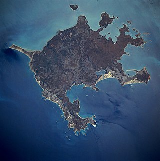
Groote Eylandt is the largest island in the Gulf of Carpentaria and the fourth largest island in Australia. It was named by the explorer Abel Tasman in 1644 and is Dutch for "Large Island" in archaic spelling. The modern Dutch spelling is Groot Eiland.
The Yolngu or Yolŋu are an aggregation of Aboriginal Australian people inhabiting north-eastern Arnhem Land in the Northern Territory of Australia. Yolngu means "person" in the Yolŋu languages. The terms Murngin, Wulamba, Yalnumata, Murrgin and Yulangor were formerly used by some anthropologists for the Yolngu.
Makassar people from the region of Sulawesi in Indonesia began visiting the coast of Northern Australia sometime around the middle of the 18th century, first in the Kimberley region, and some decades later in Arnhem Land. They were men who collected and processed trepang, a marine invertebrate prized for its culinary value generally and for its supposed medicinal properties in Chinese markets. The term Makassan is generally used to apply to all the trepangers who came to Australia.
Anindilyakwa is an Australian Aboriginal language spoken by the Anindilyakwa people on Groote Eylandt and Bickerton Island in the Gulf of Carpentaria in the Northern Territory of Australia. Anindilyakwa is a multiple-classifying prefixing language in which all traditional nouns, adjectives, personal and demonstrative pronouns are prefixed for person, number and gender. According to the 2021 Australian Census, Anindilyakwa was spoken natively by 1,516 people, an increase from 1,283 in 2006.
Trepanging is the act of collection or harvesting of sea cucumbers, known in Indonesian as trepang, Malay těripang, and used as food. The collector, or fisher, of trepang is a trepanger.
Angurugu is a community located on Groote Eylandt in the Northern Territory, Australia. The main spoken languages are Anindilyakwa, an Australian Aboriginal language, and English. Established as a Mission for the Church Mission Society, it is one of the three main indigenous settlements on the Groote Eylandt archipelago alongside Milyakburra and Umbakumba. According to the 2016 Census, the community had a population of 855, a decrease from 882 in 2006.
The East Arnhem Region is a local government area of the Northern Territory, Australia, governed by the East Arnhem Regional Council. Situated in the far north-eastern corner of the Northern Territory, the region covers an area of 33,310 square kilometres (12,861.06 sq mi) and had a population of approximately 10,345 in June 2018.
The Nunggubuyu are an Aboriginal Australian people of eastern Arnhem Land in the Northern Territory.
The Warndarrang people, (waɳʈaraŋ), also spelt Warndarang, Wanderang, and other variants were a predominantly coastal Aboriginal Australian people of eastern Northern Territory. Though extinct as a distinct ethnolinguistic group, their descendants survive among the neighbouring Nunggubuyu.
The Ngandi were an indigenous Australian people of the Northern Territory. The Ngandji are another tribe, and the two are not to be confused.
The Dhuwal are an indigenous Australian people of Arnhem Land in the Northern Territory.
The Dhuwala are an indigenous Australian people of eastern Arnhem Land in the Northern Territory.
The Ritharrngu and also known as the Diakui, are an Aboriginal Australian people of Arnhem Land in the Northern Territory, of the Yolŋu group of peoples. Their clans are Wagilak and Manggura, and Ritharrŋu.
The Daii or Dhay'yi are an indigenous Australian people of the Northern Territory.
Wurrwurrwuy stone arrangements is a heritage-listed indigenous site at Yirrkala, Northern Territory, Australia. It is also known as Wurrwurrwuy. It was added to the Northern Territory Heritage Register on 15 August 2007 and to the Australian National Heritage List on 9 August 2013.
Anne (Annie) Clarke is an Australian archaeologist and heritage specialist. She is a professor of archaeology and heritage at the University of Sydney. Clarke is a leading scholar in Australian archaeology, both historical and Aboriginal, as well as critical heritage studies. She has specialisms in archaeobotany, contact archaeology and rock art.
Umbakumba is a community located on Groote Eylandt in the Gulf of Carpentaria, Northern Territory, Australia. The main spoken languages are Anindilyakwa, an Australian Aboriginal language, and English. There are also several Yolŋu Matha speakers. It is one of the three main settlements on the Groote Eylandt archipelago, including Milyakburra and Angurugu, where Anindilyakwa is the predominant spoken language. According to the 2016 Australian Census, the population of Umbakumba was 503, an increase from 441 in 2011.
Chasm Island is an island of the Groote archipelago in the Gulf of Carpentaria, located in the state of the Northern Territory, Australia, in the northernmost part of the continent.
The Anindilyakwa Land Council (ALC) is a land council that represents the Anindilyakwa people of the Groote Archipelago in the Top End of the Northern Territory of Australia. It is one of four land councils in the Northern Territory. The head office is located in Alyangula.
The Anindilyakwa Indigenous Protected Area (IPA) is a region off the coast of Northern mainland Australia, which includes Groote Eylandt, Bickerton Island and other islands in the archipelago, managed by Anindilyakwa people. It is located around 50 km (31 mi) opposite Blue Mud Bay on the eastern coast of Arnhem Land in the Northern Territory, about 630 kilometres (390 mi) from Darwin. It covers an area of approximately 10,000km2.
This page is based on this Wikipedia article Text is available under the CC BY-SA 4.0 license; additional terms may apply. Images, videos and audio are available under their respective licenses.