
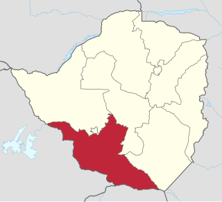
Masvingo, previously named Victoria, is a province in southeastern Zimbabwe. It has a population of 1.638 million as of the 2022 census, ranking fifth out of Zimbabwe's ten provinces. Established by the British South Africa Company, it was one of the five original provinces of Southern Rhodesia. In 1982, two years after Zimbabwean independence, it was renamed Masvingo Province. The province is divided into seven districts, including Masvingo District, which contains the provincial capital Masvingo City.
Matabeleland South is a province in southwestern Zimbabwe. With a population of 683,893 as of the 2012 Zimbabwean census. It is the country's least populated province after Matabeleland North.Matabeleland South and Matabeleland North were established in 1974, when the original Matabeleland Province was bifurcated. The province is divided into six districts. Gwanda is the capital, and Beitbridge is the province's largest town. The name "Matabeleland" is derived from Ndebele, the province's largest ethnic group.

Matabeleland is a region located in southwestern Zimbabwe that is divided into three provinces: Matabeleland North, Bulawayo, and Matabeleland South. These provinces are in the west and south-west of Zimbabwe, between the Limpopo and Zambezi rivers and are further separated from Midlands by the Shangani River in central Zimbabwe. The region is named after its inhabitants, the Ndebele people who were called "Amatabele"(people with long shields – Mzilikazi 's group of people who were escaping the Mfecani wars). Other ethnic groups who inhabit parts of Matabeleland include the Tonga, Bakalanga, Venda, Nambya, Khoisan, Xhosa, Sotho, Tswana, and Tsonga.

Zvishavane, formerly known as Shabani, is a mining town in Midlands Province, Zimbabwe. Surrounded by low hills, it lies 97 kilometres (60 mi) west of Masvingo, on the main Bulawayo-Masvingo road. Other roads lead from Zvishavane to Gweru, 121 kilometres (75 mi) north, and Mberengwa, 27 kilometres (17 mi) south-west. It is also on direct rail links to Gweru and Beit Bridge which then link up with Harare and Bulawayo in Zimbabwe and to Maputo in Mozambique, and Pretoria in South Africa. It has a private airport serving the city.

The Pioneer Column was a force raised by Cecil Rhodes and his British South Africa Company in 1890 and used in his efforts to annex the territory of Mashonaland, later part of Zimbabwe.

Victoria Falls, popularly known as Vic Falls, is a resort town and city in the province of Matabeleland North, Zimbabwe. It lies on the southern bank of the Zambezi River at the western end of Victoria Falls themselves. According to the 2022 Population Census, the town had a population of 35,199.

The Rhodesian Bush War also known as the Second Chimurenga as well as the Zimbabwean War of Independence, was a civil conflict from July 1964 to December 1979 in the unrecognised country of Rhodesia.
Shurugwi, originally known as Selukwe, is a small town and administrative centre in Midlands Province, southern Zimbabwe, located about 350 km south of Harare, with a population of 22,900 according to the 2022 census. The town was established in 1899 on the Selukwe Goldfield, which itself was discovered in the early 1890s not long after the annexation of Rhodesia by the Pioneer Column.

The Scout Association of Zimbabwe is a member of the World Organization of the Scout Movement. Scouting in Zimbabwe shares history with Malaŵi and Zambia, with which it was linked for decades.

Nkayi is a district in Matabeleland North, Zimbabwe, about 100 km (62 mi) west of Kwekwe and 168 km (104 mi) northeast of Bulawayo in Nkayi communal land. It is believed that its name originates from the Tonga word "Uyinkayi" meaning "where are you going". The main language spoken is Ndebele.

Tuli is a village in the province of Matabeleland South, in southwestern Zimbabwe. It is located about 90 km west of Beitbridge on the eastern bank of the Shashe River. The village grew around Fort Tuli, which was the first settlement built by the Pioneer Column in July 1890 at the place known as Selous Camp and used by Frederick Selous as a base for his hunting expeditions. The village is mainly a police post and associated housing.
Khezi is a village in Matobo District, Matabeleland South province in Zimbabwe. It is located 100 km (62 mi) south of Bulawayo, 10 km (6.2 mi) from Maphisa, a small town which serves as the seat of Matobo District, and 76 km (47 mi) from the province's capital Gwanda.

Grey's Scouts were a Rhodesian mounted infantry unit raised in July 1975 and named after George Grey, a British soldier and governor. Based in Salisbury it patrolled Rhodesia's borders during the Rhodesian Bush War, and then became a regiment of the Special Forces of Zimbabwe in June 1980. It was totally disbanded in July 1986 because of a lack of resources.
Europeans first came to the region in southern Africa today called Zimbabwe in the sixteenth century, when Portuguese colonials ventured inland from Mozambique and attacked the Kingdom of Mutapa, which then controlled an area roughly equivalent to eastern Zimbabwe and western Mozambique. Portuguese influence over Mutapa endured for about two centuries before fading away during the 1690s and early-1700s (decade). During the year of 1685, French Huguenots emigrated to present-day South Africa and whilst some settled there, others moved further north into the continent. Those who did, settled within modern-day Zimbabwe, Mozambique and Botswana, and co-existed with the indigenous people; most of whom, in Zimbabwe, were the Naletale people.
The Ministry of Internal Affairs, commonly referred to as INTAF, was a cabinet ministry of the Rhodesian government. One of Rhodesia's most important governmental departments, it was responsible for the welfare and development of the black African rural population. It played a significant role maintaining control of rural African villages during the Rhodesian Bush War.
Blanket Mine is a village and mine in the province of Matabeleland South, Zimbabwe. It is located about 15 km north-west of Gwanda and 140 km south of Bulawayo. The village grew up around the eponymous gold mine and provides a residential and commercial centre. Its population at the time of the 1982 census was 1,346 people.

The British South Africa Company's administration of what became Rhodesia was chartered in 1889 by Queen Victoria of the United Kingdom, and began with the Pioneer Column's march north-east to Mashonaland in 1890. Empowered by its charter to acquire, govern and develop the area north of the Transvaal in southern Africa, the Company, headed by Cecil Rhodes, raised its own armed forces and carved out a huge bloc of territory through treaties, concessions and occasional military action, most prominently overcoming the Matabele army in the First and Second Matabele Wars of the 1890s. By the turn of the century, Rhodes's Company held a vast, land-locked country, bisected by the Zambezi river. It officially named this land Rhodesia in 1895, and ran it until the early 1920s.
The Kwekwe-Gokwe Highway or the R84-7 Highway is an all-weather bitumen macadam highway in Zimbabwe running from Kwekwe to Gokwe passing through Zhombe. As a trunk road it is officially designated as the P11 Highway.

Umzingwane is a district in the northern part of Matabeleland South province in Zimbabwe. It was formerly known as Esigodini and before 1982 as Essexvale.
Maphisa is a small town in the Matobo District of the province of Matabeleland South. It also serves as the seat of Matobo Rural District Council and ultimately the district's largest business centre and development node. Three kilometres west of Maphisa is the Bhalagwe mountain on the Maphisa to Matjilotje Road. Maphisa Town's economic activity includes extensive gold mining by both large scale and artisanal miners. There are also many informal miners locally known as 'oTsheketshe'. It also boasts in excess of a 1500 hectare intensive farming under pivot irrigation system. There is also extensive commercial ranching in its precinct. The legendary liberation fighter Joshua Mqabuko Nkomo's home village is 40km South West of Maphisa. The amenities found in Maphisa include a modern hotel, Minda Mission which provides education from primary to Advanced level. There are modern supermarkets, a referral Maphisa Hospital and Hlalani Kuhle suburb. King Mzilikazi's grave and Cecil John Rhodes's grave are 84km and 65km respectively North East of Maphisa. The Matobo national park, a World Heritage Site is located 50km North East of Maphisa. SADC Icrisat is located 70km North East of Maphisa.
