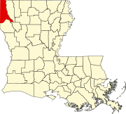
DeSoto Parish is a parish located in the U.S. state of Louisiana. The parish was formed in 1843. At the 2020 U.S. census, the population was 26,812. Its parish seat is Mansfield. DeSoto Parish is part of the Shreveport–Bossier City metropolitan statistical area.
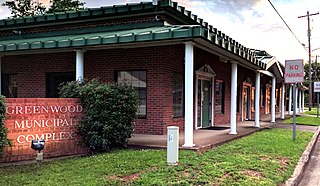
Greenwood is a suburban town in southern Caddo Parish, which is located in the northwest corner of the U.S. state of Louisiana. With a population of 3,166 at the 2020 United States census, it is the third most populous incorporated municipality in Caddo Parish after Shreveport and Blanchard. Part of the Shreveport-Bossier City metropolitan statistical area, it is located 15 miles west of downtown Shreveport.
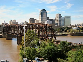
Shreveport is a city in the U.S. state of Louisiana. It is the third most populous city in Louisiana after New Orleans and Baton Rouge. The Shreveport–Bossier City metropolitan area, with a population of 393,406 in 2020, is the fourth largest in Louisiana, though 2020 census estimates placed its population at 397,590. The bulk of Shreveport is in Caddo Parish, of which it is the parish seat. It extends along the west bank of the Red River into neighboring Bossier Parish. The United States Census Bureau's 2020 census tabulation for the city's population was 187,593, though the American Community Survey's census estimates determined 189,890 residents.

The Ark-La-Tex is a socio-economic tri-state region where the Southern U.S. states of Arkansas, Louisiana, and Texas join together. The region contains portions of Northwest Louisiana, Northeast Texas, and South Arkansas as well as the extreme southeastern tip of Oklahoma, in McCurtain County, partly centered upon the Red River, which flows along the Texas–Oklahoma state line into Southwestern Arkansas and Northwest Louisiana.
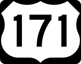
U.S. Highway 171 (US 171) is a part of the United States Numbered Highway System and the only route within that system currently located entirely within the state of Louisiana. It spans 177.44 miles (285.56 km) in a north–south direction from the junction of US 90 and Louisiana Highway 14 (LA 14) in Lake Charles to the junction of US 79/US 80 and LA 3094 in Shreveport.

Caddo Parish is a parish located in the northwestern corner of the U.S. state of Louisiana. According to the 2020 U.S. census, the parish had a population of 237,848. The parish seat is Shreveport, which developed along the Red River.

C. E. Byrd, a Blue Ribbon School, is a high school in Shreveport, Louisiana, United States. In continuous operation since its establishment in 1925, C. E. Byrd is also the eighth-largest high school in the United States of America as of February 2019. Byrd students come from its neighborhood or throughout the entire school district through its selective math/science magnet program.
The Shreveport–Bossier City metropolitan area, officially designated Shreveport–Bossier City by the U.S. Office of Management and Budget, or simply Greater Shreveport, is a metropolitan statistical area in northwestern Louisiana that covers three parishes: Caddo, Bossier, and DeSoto. At the 2020 United States census, the metropolitan region had a population of 393,406; its American Community Survey population was 397,590 per census estimates. With a 2010 census population of 439,000, it declined to become Louisiana's fourth largest metropolis at 394,706 residents at the 2019 census estimates.

Caesar Carpentier Antoine (1836–1921) was a soldier, businessman, editor, and African-American Republican politician in Louisiana during the Reconstruction era.

A. C. Steere Elementary School, formerly Broadmoor School, is an elementary school located at 4009 Youree Drive in Shreveport, Louisiana, and operated under the direction of the Caddo Parish school board.

The Shreveport Waterworks Pumping Station, also known as the McNeil Street Pump Station, is a historic water pumping station at 142 North Common Street in Shreveport, Louisiana. Now hosting the Shreveport Water Works Museum, it exhibits in situ a century's worth of water pumping equipment, and was the nation's last steam-powered waterworks facility when it was shut down in 1980.
Keithville is an unincorporated community in Caddo Parish, Louisiana, United States. It lies to the south of Shreveport along U.S. Route 171. Although unincorporated, it has a post office, with the ZIP code of 71047.

Fair Park Middle School is a former high school located at 3222 Greenwood Road in Shreveport, Louisiana, United States. The school was originally named Fair Park High School when it opened in 1928, and it was the second high school in the city. C.E. Byrd High School had opened three years earlier in 1925. The institution was also previously named Fair Park College Preparatory High School or Fair Park College Prep Academy, and additionally had been named Fair Park Medical Careers Magnet High School.
This is a list of the National Register of Historic Places listings in Caddo Parish, Louisiana.

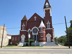
Holy Trinity Catholic Church in Shreveport, Louisiana was built in 1896. It was listed on the National Register of Historic Places in 1984. The current structure is the third church, with the first being constructed in 1856 by Fr. Jean Pierre, who became the first pastor. During the city's Yellow Fever epidemic of 1873, Fr. Jean Pierre and his assistant pastor, Fr. Isidore Quemerais, both gave their lives while caring for the sick and dying.
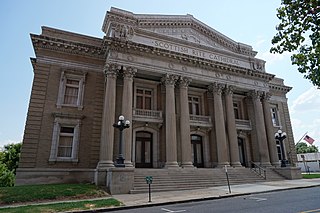
The Scottish Rite Cathedral is a historic building located at 725 Cotton Street in Shreveport, Louisiana. It was designed in 1915 by architect Edward F. Neild in Beaux Arts style.

B'Nai Zion Temple is a historic Jewish temple located in downtown Shreveport, Louisiana. It was constructed in 1914 and dedicated in 1915.

The Church of the Holy Cross (Episcopal), which housed St. Mark's until 1954, is a historic church at 875 Cotton Street in Shreveport, Louisiana, United States. The first services of the Episcopal church in Shreveport were celebrated by the Rt. Rev. Leonidas Polk, the Bishop of Louisiana in March 1839. That liturgy is considered the founding day of St. Mark's Church. Prior to this church building, the church was located on Fannin Street. St. Mark's moved into a new church building at Fairfield Avenue and Rutherford Street in 1954. That church became the cathedral of the Diocese of Western Louisiana on July 7, 1990.
The following is a timeline of the history of the city of Shreveport, Louisiana, USA.