National Register of Historic Places listings in St. Bernard Parish, Louisiana

Last updated
Location of St. Bernard Parish in Louisiana Map of Louisiana highlighting St. Bernard Parish.svg
Location of St. Bernard Parish in Louisiana

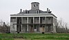
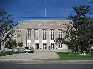
This is a list of the National Register of Historic Places listings in St. Bernard Parish, Louisiana.

Contents

This is intended to be a complete list of the properties on the National Register of Historic Places in St. Bernard Parish, Louisiana, United States. The locations of National Register properties for which the latitude and longitude coordinates are included below, may be seen in a map. [1]

National Register of Historic Places federal list of historic sites in the United States

The National Register of Historic Places (NRHP) is the United States federal government's official list of districts, sites, buildings, structures, and objects deemed worthy of preservation for their historical significance. A property listed in the National Register, or located within a National Register Historic District, may qualify for tax incentives derived from the total value of expenses incurred preserving the property.

St. Bernard Parish, Louisiana Parish in the United States

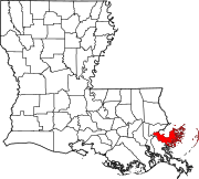
St. Bernard Parish is a parish located in the U.S. state of Louisiana. As of the 2010 census, the population was 35,897. The parish seat and largest community is Chalmette. The parish was formed in 1807.

Louisiana State of the United States of America

Louisiana is a state in the Deep South region of the South Central United States. It is the 31st most extensive and the 25th most populous of the 50 United States. Louisiana is bordered by the state of Texas to the west, Arkansas to the north, Mississippi to the east, and the Gulf of Mexico to the south. A large part of its eastern boundary is demarcated by the Mississippi River. Louisiana is the only U.S. state with political subdivisions termed parishes, which are equivalent to counties. The state's capital is Baton Rouge, and its largest city is New Orleans.

There are 12 properties listed on the National Register in the parish.

This National Park Service list is complete through NPS recent listings posted May 3, 2019. [2]
Map all coordinates using: OpenStreetMap  
Download coordinates as: KML  ·  GPX

Current listings

[3] Name on the RegisterImageDate listed [4] Location City or townDescription
1 1939 St. Bernard Parish Courthouse January 31, 2019
(#100003376)
1101 W. St. Bernard Hwy.
29°56′24″N89°58′27″W / 29.9401°N 89.9741°W / 29.9401; -89.9741 (1939 St. Bernard Parish Courthouse)
Chalmette
2 Chalmette Unit of Jean Lafitte National Historical Park
Chalmette Unit of Jean Lafitte National Historical Park CHALMETTE UNIT OF JEAN LAFITTE NATIONAL HISTORICAL PARK HISTORIC DISTRICT.jpg
Chalmette Unit of Jean Lafitte National Historical Park
October 15, 1966
(#66000889)
6 miles (9.7 km) south of New Orleans
29°56′31″N89°59′26″W / 29.941944°N 89.990556°W / 29.941944; -89.990556 (Chalmette Unit of Jean Lafitte National Historical Park)
Chalmette Site of the 1815 Battle of New Orleans; park includes monument, visitor center, and national cemetery.
3 Chandeleur Light
Chandeleur Light Chandeleur Island Light LA 1971.jpg
Chandeleur Light
June 25, 1986
(#86001404)
Breton National Wildlife Refuge
30°02′52″N88°52′18″W / 30.047778°N 88.871667°W / 30.047778; -88.871667 (Chandeleur Light)
Chandeleur Islands, Gulf of MexicoLighthouse dating from 1848, destroyed by Hurricane Katrina in 2005.
4 Dr. Louis A. Ducros House
Dr. Louis A. Ducros House Ducros House.jpg
Dr. Louis A. Ducros House
June 9, 2014
(#14000315)
1345 Bayou Ave.
29°52′05″N89°51′37″W / 29.867982°N 89.86022°W / 29.867982; -89.86022 (Dr. Louis A. Ducros House)
St. Bernard
5 Ford Motor Company Assembly Plant
Ford Motor Company Assembly Plant Arabi 21Dec2013 Old Ford Plant.JPG
Ford Motor Company Assembly Plant
June 22, 2018
(#100002589)
7200 N Peters St.
29°56′47″N90°00′17″W / 29.9464°N 90.0048°W / 29.9464; -90.0048 (Ford Motor Company Assembly Plant)
Arabi
6 Fort Proctor
Fort Proctor FortProctorLongViewShellBeach.jpg
Fort Proctor
September 20, 1978
(#78003067)
North of Shell Beach on Lake Borgne
29°52′02″N89°40′42″W / 29.867222°N 89.678333°W / 29.867222; -89.678333 (Fort Proctor)
Shell Beach Ruins of a mid-19th century fortification intended for the defense of New Orleans; built on the land adjacent to Lake Borgne, it has been surrounded by water since the mid-20th century.
7 Friscoville Street Historic District
Friscoville Street Historic District ArabiFriscovilleAug08SchoolB.jpg
Friscoville Street Historic District
July 9, 1998
(#98000837)
100-900 blocks of Friscoville St.
29°57′01″N90°00′04″W / 29.950278°N 90.001111°W / 29.950278; -90.001111 (Friscoville Street Historic District)
Arabi
8 Kenilworth Plantation House
Kenilworth Plantation House KenilworthLAPlantationHouseFront.JPG
Kenilworth Plantation House
April 24, 2006
(#06000317)
2931 Bayou Rd.
29°52′02″N89°48′51″W / 29.867222°N 89.814167°W / 29.867222; -89.814167 (Kenilworth Plantation House)
St. Bernard Circa-1820 antebellum plantation home; built in the French Creole architectural style, it is one of the few remaining and best-preserved examples.
9 Magnolia Mound May 22, 1978
(#78003068)
Address Restricted
St. Bernard
10 Old Arabi Historic District
Old Arabi Historic District Arabi20FebLeBeau1.jpg
Old Arabi Historic District
July 9, 1998
(#98000836)
Roughly along parts of Angela, Mehle, and Esteban Sts.
29°57′06″N90°00′28″W / 29.951667°N 90.007778°W / 29.951667; -90.007778 (Old Arabi Historic District)
Arabi
11 Pecan Grove Plantation House March 20, 2013
(#13000094)
10 Pecan Grove Ln.
29°55′44″N89°55′41″W / 29.928902°N 89.927994°W / 29.928902; -89.927994 (Pecan Grove Plantation House)
Meraux
12 Sebastopol Plantation House
Sebastopol Plantation House Sebastopol Plantation.jpg
Sebastopol Plantation House
August 13, 1986
(#86001495)
Louisiana Highway 46
29°52′04″N89°52′21″W / 29.867778°N 89.8725°W / 29.867778; -89.8725 (Sebastopol Plantation House)
St. Bernard

See also

National Register of Historic Places listings in Louisiana Wikimedia list article

This is a list of properties and districts in Louisiana that are listed on the National Register of Historic Places. There are listings in each of Louisiana's 64 parishes.

Related Research Articles

National Register of Historic Places listings in Orleans Parish, Louisiana Wikimedia list article

This is a list of the National Register of Historic Places listings in Orleans Parish, Louisiana.

National Register of Historic Places listings in Natchitoches Parish, Louisiana Wikimedia list article

This is a list of the National Register of Historic Places listings in Natchitoches Parish, Louisiana.

National Register of Historic Places listings in East Feliciana Parish, Louisiana Wikimedia list article

This is a list of the National Register of Historic Places listings in East Feliciana Parish, Louisiana.

National Register of Historic Places listings in West Feliciana Parish, Louisiana Wikimedia list article

This is a list of the National Register of Historic Places listings in West Feliciana Parish, Louisiana.

National Register of Historic Places listings in DeSoto Parish, Louisiana Wikimedia list article

This is a list of the National Register of Historic Places listings in DeSoto Parish, Louisiana.

National Register of Historic Places listings in St. James Parish, Louisiana Wikimedia list article

This is a list of the National Register of Historic Places listings in St. James Parish, Louisiana.

National Register of Historic Places listings in Vernon Parish, Louisiana Wikimedia list article

This is a list of the National Register of Historic Places listings in Vernon Parish, Louisiana.

National Register of Historic Places listings in Assumption Parish, Louisiana Wikimedia list article

This is a list of the National Register of Historic Places listings in Assumption Parish, Louisiana.

National Register of Historic Places listings in Cameron Parish, Louisiana Wikimedia list article

This is a list of the National Register of Historic Places listings in Cameron Parish, Louisiana.

National Register of Historic Places listings in Jackson Parish, Louisiana Wikimedia list article

This is a list of the National Register of Historic Places listings in Jackson Parish, Louisiana.

National Register of Historic Places listings in Bossier Parish, Louisiana Wikimedia list article

This is a list of the National Register of Historic Places listings in Bossier Parish, Louisiana.

National Register of Historic Places listings in Union Parish, Louisiana Wikimedia list article

This is a list of the National Register of Historic Places listings in Union Parish, Louisiana.

National Register of Historic Places listings in Beauregard Parish, Louisiana Wikimedia list article

This is a list of the National Register of Historic Places listings in Beauregard Parish, Louisiana.

National Register of Historic Places listings in Allen Parish, Louisiana Wikimedia list article

This is a list of the National Register of Historic Places listings in Allen Parish, Louisiana.

National Register of Historic Places listings in La Salle Parish, Louisiana Wikimedia list article

This is a list of the National Register of Historic Places listings in La Salle Parish, Louisiana.

National Register of Historic Places listings in Livingston Parish, Louisiana Wikimedia list article

This is a list of the National Register of Historic Places listings in Livingston Parish, Louisiana.

National Register of Historic Places listings in Morehouse Parish, Louisiana Wikimedia list article

This is a list of the National Register of Historic Places listings in Morehouse Parish, Louisiana.

National Register of Historic Places listings in Red River Parish, Louisiana Wikimedia list article

This is a list of the National Register of Historic Places listings in Red River Parish, Louisiana.

National Register of Historic Places listings in Sabine Parish, Louisiana Wikimedia list article

This is a list of the National Register of Historic Places listings in Sabine Parish, Louisiana.

National Register of Historic Places listings in St. Helena Parish, Louisiana Wikimedia list article

This is a list of the National Register of Historic Places listings in St. Helena Parish, Louisiana.

References

  1. The latitude and longitude information provided in this table was derived originally from the National Register Information System, which has been found to be fairly accurate for about 99% of listings. For about 1% of NRIS original coordinates, experience has shown that one or both coordinates are typos or otherwise extremely far off; some corrections may have been made. A more subtle problem causes many locations to be off by up to 150 yards, depending on location in the country: most NRIS coordinates were derived from tracing out latitude and longitudes from USGS topographical quadrant maps created under the North American Datum of 1927 , which differs from the current, highly accurate WGS84 GPS system used by most on-line maps. Chicago is about right, but NRIS longitudes in Washington are higher by about 4.5 seconds, and are lower by about 2.0 seconds in Maine. Latitudes differ by about 1.0 second in Florida. Some locations in this table may have been corrected to current GPS standards.
  2. "National Register of Historic Places: Weekly List Actions". National Park Service, United States Department of the Interior. Retrieved on May 3, 2019.
  3. Numbers represent an ordering by significant words. Various colorings, defined here, differentiate National Historic Landmarks and historic districts from other NRHP buildings, structures, sites or objects.
  4. The eight-digit number below each date is the number assigned to each location in the National Register Information System database, which can be viewed by clicking the number.