National Register of Historic Places listings in Pointe Coupee Parish, Louisiana

Last updated

Location of Pointe Coupee Parish in Louisiana Map of Louisiana highlighting Pointe Coupee Parish.svg
Location of Pointe Coupee Parish in Louisiana

This is a list of the National Register of Historic Places listings in Pointe Coupee Parish, Louisiana.

Contents

This is intended to be a complete list of the properties on the National Register of Historic Places in Pointe Coupee Parish, Louisiana, United States. The locations of National Register properties for which the latitude and longitude coordinates are included below, may be seen in a map. [1]

There are 33 properties listed on the National Register in the parish, including 1 National Historic Landmark.


    This National Park Service list is complete through NPS recent listings posted March 22, 2024. [2]

Current listings

[3] Name on the Register [4] ImageDate listed [5] Location City or townDescription
1 Austerlitz
Austerlitz Austerlitz1.JPG
Austerlitz
April 22, 1991
(#91000416)
Louisiana Highway 1 southeast of its junction with Louisiana Highway 78
30°37′15″N91°28′40″W / 30.620833°N 91.477778°W / 30.620833; -91.477778 (Austerlitz)
Oscar
2 Jean Baptiste Bergeron House
Jean Baptiste Bergeron House JEAN BAPTISTE BERGERON HOUSE, POINTE COUPEE PARISH, LA.jpg
Jean Baptiste Bergeron House
May 13, 1994
(#94000407)
13769 Chenal Rd.
30°36′40″N91°22′51″W / 30.611111°N 91.380833°W / 30.611111; -91.380833 (Jean Baptiste Bergeron House)
Jarreau
3 Valmont Bergeron House
Valmont Bergeron House VALMONT BERGERON HOUSE, POINTE COUPEE PARISH, LA.jpg
Valmont Bergeron House
May 14, 1992
(#92000512)
Louisiana Highway 414
30°36′43″N91°22′49″W / 30.611944°N 91.380278°W / 30.611944; -91.380278 (Valmont Bergeron House)
Jarreau
4 Bonnie Glen
Bonnie Glen BonnieGlen11.JPG
Bonnie Glen
January 11, 1980
(#80001749)
Southwest of New Roads on Louisiana Highway 1
30°39′16″N91°29′12″W / 30.654444°N 91.486667°W / 30.654444; -91.486667 (Bonnie Glen)
New Roads vicinity
5 Cherie Quarters Cabins
Cherie Quarters Cabins Cherie Cabin.JPG
Cherie Quarters Cabins
April 26, 1995
(#95000470)
Major Ln., approximately ½ mile from its junction with Louisiana Highway 1
30°36′03″N91°26′10″W / 30.600833°N 91.436111°W / 30.600833; -91.436111 (Cherie Quarters Cabins)
Oscar Two surviving of 30 or more original slave quarters cabins of Riverlake plantation, dating from c.1840.
6 Jacques Dupre House
Jacques Dupre House JACQUES DUPRE HOUSE, POINTE COUPEE PARISH, LA.jpg
Jacques Dupre House
December 5, 2003
(#03001232)
13987 Chenal Rd.
30°36′49″N91°22′48″W / 30.613611°N 91.38°W / 30.613611; -91.38 (Jacques Dupre House)
Jarreau
7 El Dorado Plantation House
El Dorado Plantation House EldoradoLA11.JPG
El Dorado Plantation House
March 24, 1982
(#82002791)
Bayou Maringouin, Louisiana Highway 77
30°31′20″N91°32′45″W / 30.522222°N 91.545833°W / 30.522222; -91.545833 (El Dorado Plantation House)
Livonia vicinity
8 First National Bank
First National Bank NR1Bank11.JPG
First National Bank
June 20, 2002
(#02000653)
102 E. Main St.
30°41′33″N91°26′03″W / 30.6925°N 91.434167°W / 30.6925; -91.434167 (First National Bank)
New Roads
9 Glynnwood
Glynnwood Glynnwood Plantation.JPG
Glynnwood
November 2, 1982
(#82000452)
Louisiana Highway 416
30°37′27″N91°21′24″W / 30.624167°N 91.356667°W / 30.624167; -91.356667 (Glynnwood)
Glynn
10 Labatut
Labatut Labatut11.JPG
Labatut
August 15, 1991
(#91001056)
Junction of Louisiana Highways 10 and Louisiana Highway 420
30°43′45″N91°29′00″W / 30.729167°N 91.483333°W / 30.729167; -91.483333 (Labatut)
New Roads vicinity
11 Lakeside March 29, 1984
(#84001346)
Louisiana Highway 419
30°50′15″N91°38′40″W / 30.8375°N 91.644444°W / 30.8375; -91.644444 (Lakeside)
Batchelor
12 LeBeau House and Kitchen May 9, 1985
(#85000974)
Louisiana Highway 414
30°37′10″N91°22′35″W / 30.619444°N 91.376389°W / 30.619444; -91.376389 (LeBeau House and Kitchen)
Jarreau
13 LeJeune House
LeJeune House LeJeuneHouse11.JPG
LeJeune House
November 28, 1978
(#78001435)
507 E. Main St.
30°41′40″N91°25′47″W / 30.694444°N 91.429722°W / 30.694444; -91.429722 (LeJeune House)
New Roads
14 Albin Major House
Albin Major House AlbinMajor11.JPG
Albin Major House
April 22, 1991
(#91000415)
1304 False River Rd. (Louisiana Highway 1)
30°41′22″N91°26′50″W / 30.689444°N 91.447222°W / 30.689444; -91.447222 (Albin Major House)
New Roads
15 Mix Store and Post Office
Mix Store and Post Office Mix Store 2.jpg
Mix Store and Post Office
June 19, 2018
(#100002587)
9253 False River Rd.
30°39′30″N91°29′04″W / 30.6583°N 91.4845°W / 30.6583; -91.4845 (Mix Store and Post Office)
Mix
16 New Roads Commercial Historic District March 19, 2024
(#100008456)
453 East Main to 348 West Main, 107-121 Court, 124-151 New Roads, 142 St. Mary, and 112-159 Richey Sts.; Morrison Pkwy.
30°41′36″N91°26′02″W / 30.6933°N 91.4340°W / 30.6933; -91.4340 (New Roads Commercial Historic District)
New Roads
17 North Bend
North Bend North Bend Plantation PC.jpeg
North Bend
October 8, 1992
(#92001336)
Louisiana Highway 1 west of its junction with Louisiana Highway 416, east of Oscar
30°36′41″N91°26′52″W / 30.611389°N 91.447778°W / 30.611389; -91.447778 (North Bend)
Oscar
18 Old Hickory
Old Hickory Old Hickory Plantation.JPG
Old Hickory
June 15, 1979
(#79001081)
Southeast of LaCour
30°49′27″N91°36′11″W / 30.824167°N 91.603056°W / 30.824167; -91.603056 (Old Hickory)
Lacour
19 Parlange Plantation House
Parlange Plantation House Parlange Plantation, State Highway 93, New Roads vicinity (Pointe Coupee Parish, Louisiana).jpg
Parlange Plantation House
April 15, 1970
(#70000258)
Junction of Louisiana Highways 1 and 78
30°37′49″N91°29′14″W / 30.630278°N 91.487222°W / 30.630278; -91.487222 (Parlange Plantation House)
Mix 
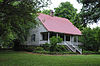
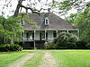
Large two-story French Colonial home built circa 1750 by Vincent de Ternant. Used as military headquarters by both C.S.A. and Union generals during the Civil War. Open by appointment.
20 Pleasant View Plantation House April 5, 1984
(#84001347)
Louisiana Highway 1
30°36′51″N91°27′28″W / 30.614167°N 91.457778°W / 30.614167; -91.457778 (Pleasant View Plantation House)
Oscar
21 Pointe Coupee Parish Courthouse
Pointe Coupee Parish Courthouse Pointe Coupee Courthouse.jpg
Pointe Coupee Parish Courthouse
October 7, 1981
(#81000710)
Main St.
30°41′38″N91°25′57″W / 30.693889°N 91.4325°W / 30.693889; -91.4325 (Pointe Coupee Parish Courthouse)
New Roads
22 Pointe Coupee Parish Museum
Pointe Coupee Parish Museum DPCMuseumWM.jpg
Pointe Coupee Parish Museum
September 30, 1980
(#80001750)
6 miles southwest of New Roads on Louisiana Highway 1
30°37′59″N91°29′13″W / 30.633056°N 91.486944°W / 30.633056; -91.486944 (Pointe Coupee Parish Museum)
New Roads vicinity
23 Poydras High School
Poydras High School Poydras High School.jpg
Poydras High School
March 7, 1996
(#96000229)
500 W. Main St.
30°41′34″N91°26′16″W / 30.692778°N 91.437778°W / 30.692778; -91.437778 (Poydras High School)
New Roads
24 Fannie Riche House
Fannie Riche House Fannie Riche Plantation, State Highway 30, New Roads vicinity (Pointe Coupee Parish, Louisiana).jpg
Fannie Riche House
April 22, 1991
(#91000413)
Louisiana Highway 420 near its junction with Louisiana Highway 10
30°43′46″N91°28′19″W / 30.729444°N 91.471944°W / 30.729444; -91.471944 (Fannie Riche House)
New Roads vicinity
25 Riverlake
Riverlake Riverlake.jpg
Riverlake
April 13, 1983
(#83000534)
Louisiana Highway 1
30°36′28″N91°26′07″W / 30.60764°N 91.43528°W / 30.60764; -91.43528 (Riverlake)
Oscar Creole-style plantation house on False River, dating from c. 1820.
26 St. Francis Chapel
St. Francis Chapel StFrancis2.JPG
St. Francis Chapel
May 25, 1979
(#79001082)
Northwest of New Roads on Louisiana Highway 10
30°43′45″N91°29′12″W / 30.729167°N 91.486667°W / 30.729167; -91.486667 (St. Francis Chapel)
New Roads vicinity
27 St. Stephen's Episcopal Church
St. Stephen's Episcopal Church St. Stephens Episcopal Church (Innis, Louisiana).jpg
St. Stephen's Episcopal Church
April 24, 1974
(#74000939)
North of Innis off Louisiana Highway 418
30°53′52″N91°40′09″W / 30.897778°N 91.669167°W / 30.897778; -91.669167 (St. Stephen's Episcopal Church)
Innis
28 Saizon House
Saizon House SAIZON HOUSE, POINTE COUPEE PARISH, LA.jpg
Saizon House
April 22, 1991
(#91000417)
Louisiana Highway 414 east of its junction with Louisiana Highway 413
30°36′32″N91°23′03″W / 30.608889°N 91.384167°W / 30.608889; -91.384167 (Saizon House)
Jarreau
29 Samson House
Samson House SamsonHouse11.JPG
Samson House
December 19, 1997
(#97001515)
405 Richey St.
30°41′45″N91°26′08″W / 30.695833°N 91.435556°W / 30.695833; -91.435556 (Samson House)
New Roads
30 Satterfield Motor Company Building
Satterfield Motor Company Building Satterfield11.JPG
Satterfield Motor Company Building
July 7, 1994
(#94000700)
108 E. Main St.
30°41′34″N91°26′01″W / 30.692778°N 91.433611°W / 30.692778; -91.433611 (Satterfield Motor Company Building)
New Roads
31 Valverda Plantation House
Valverda Plantation House Valverde12.JPG
Valverda Plantation House
April 1, 2002
(#02000297)
2217 Louisiana Highway 977
30°32′19″N91°32′43″W / 30.538611°N 91.545278°W / 30.538611; -91.545278 (Valverda Plantation House)
Maringouin vicinityLocated in Pointe Coupee Parish but with an Iberville Parish mailing address.
32 White Hall Plantation House
White Hall Plantation House White Hall Plantation.jpg
White Hall Plantation House
May 26, 1977
(#77000677)
Louisiana Highway 418
30°58′59″N91°46′42″W / 30.983056°N 91.778333°W / 30.983056; -91.778333 (White Hall Plantation House)
Lettsworth 
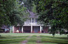
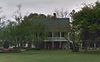
Late 1840s Italianate and Greek Revival mansion attributed to architect Henry Howard. Used as a headquarters by Union General Nathaniel Banks in 1863. Restored and opened to the public in 2013.
33 Wickliffe
Wickliffe Wickliffe Plantation.jpg
Wickliffe
April 22, 1991
(#91000414)
Louisiana Highway 415 east of Patin Duke Slough
30°40′59″N91°22′58″W / 30.683056°N 91.382778°W / 30.683056; -91.382778 (Wickliffe)
New Roads vicinity

Former listings

[3] Name on the RegisterImageDate listedDate removedLocationCity or townDescription
1 Ovide LaCour Store July 27, 1979
(#79001080)
November 29, 2016 Louisiana Highway 419
30°49′40″N91°36′38″W / 30.827778°N 91.610556°W / 30.827778; -91.610556 (Ovide LaCour Store)
Lacour

See also

Related Research Articles

<span class="mw-page-title-main">National Register of Historic Places listings in Natchitoches Parish, Louisiana</span>

This is a list of the National Register of Historic Places listings in Natchitoches Parish, Louisiana.

<span class="mw-page-title-main">National Register of Historic Places listings in East Feliciana Parish, Louisiana</span>

This is a list of the National Register of Historic Places listings in East Feliciana Parish, Louisiana.

<span class="mw-page-title-main">National Register of Historic Places listings in Ouachita Parish, Louisiana</span>

This is a list of the National Register of Historic Places listings in Ouachita Parish, Louisiana.

<span class="mw-page-title-main">National Register of Historic Places listings in St. Martin Parish, Louisiana</span>

This is a list of the National Register of Historic Places listings in St. Martin Parish, Louisiana.

<span class="mw-page-title-main">National Register of Historic Places listings in Webster Parish, Louisiana</span>

This is a list of the National Register of Historic Places listings in Webster Parish, Louisiana.

<span class="mw-page-title-main">National Register of Historic Places listings in St. John the Baptist Parish, Louisiana</span>

This is a list of the National Register of Historic Places listings in St. John the Baptist Parish, Louisiana.

<span class="mw-page-title-main">National Register of Historic Places listings in Vermilion Parish, Louisiana</span>

This is a list of the National Register of Historic Places listings in Vermilion Parish, Louisiana.

<span class="mw-page-title-main">National Register of Historic Places listings in Washington Parish, Louisiana</span>

This is a list of the National Register of Historic Places listings in Washington Parish, Louisiana.

<span class="mw-page-title-main">National Register of Historic Places listings in Tensas Parish, Louisiana</span>

This is a list of the National Register of Historic Places listings in Tensas Parish, Louisiana.

<span class="mw-page-title-main">National Register of Historic Places listings in Assumption Parish, Louisiana</span>

This is a list of the National Register of Historic Places listings in Assumption Parish, Louisiana.

<span class="mw-page-title-main">National Register of Historic Places listings in Cameron Parish, Louisiana</span>

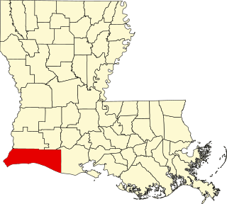
This is a list of the National Register of Historic Places listings in Cameron Parish, Louisiana.

<span class="mw-page-title-main">National Register of Historic Places listings in Jackson Parish, Louisiana</span>

This is a list of the National Register of Historic Places listings in Jackson Parish, Louisiana.

<span class="mw-page-title-main">National Register of Historic Places listings in Bossier Parish, Louisiana</span>

This is a list of the National Register of Historic Places listings in Bossier Parish, Louisiana.

<span class="mw-page-title-main">National Register of Historic Places listings in Union Parish, Louisiana</span>

This is a list of the National Register of Historic Places listings in Union Parish, Louisiana.

<span class="mw-page-title-main">National Register of Historic Places listings in St. Charles Parish, Louisiana</span>

This is a list of the National Register of Historic Places listings in St. Charles Parish, Louisiana.

<span class="mw-page-title-main">National Register of Historic Places listings in LaSalle Parish, Louisiana</span>

This is a list of the National Register of Historic Places listings in LaSalle Parish, Louisiana.

<span class="mw-page-title-main">National Register of Historic Places listings in Morehouse Parish, Louisiana</span>

This is a list of the National Register of Historic Places listings in Morehouse Parish, Louisiana.

<span class="mw-page-title-main">National Register of Historic Places listings in Red River Parish, Louisiana</span>

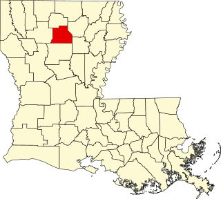
This is a list of the National Register of Historic Places listings in Red River Parish, Louisiana.

<span class="mw-page-title-main">National Register of Historic Places listings in Sabine Parish, Louisiana</span>

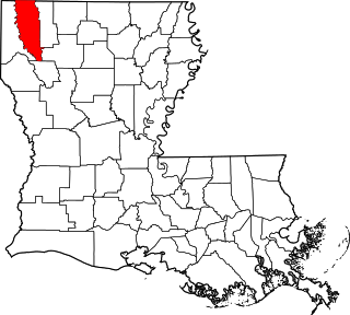
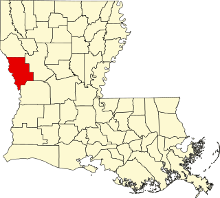
This is a list of the National Register of Historic Places listings in Sabine Parish, Louisiana.

<span class="mw-page-title-main">National Register of Historic Places listings in St. Helena Parish, Louisiana</span>

This is a list of the National Register of Historic Places listings in St. Helena Parish, Louisiana.

References

  1. The latitude and longitude information provided in this table was derived originally from the National Register Information System, which has been found to be fairly accurate for about 99% of listings. Some locations in this table may have been corrected to current GPS standards.
  2. National Park Service, United States Department of the Interior, "National Register of Historic Places: Weekly List Actions", retrieved March 22, 2024.
  3. 1 2 Numbers represent an alphabetical ordering by significant words. Various colorings, defined here, differentiate National Historic Landmarks and historic districts from other NRHP buildings, structures, sites or objects.
  4. "National Register Information System". National Register of Historic Places . National Park Service. March 13, 2009.
  5. The eight-digit number below each date is the number assigned to each location in the National Register Information System database, which can be viewed by clicking the number.