National Register of Historic Places listings in Caddo Parish, Louisiana

Last updated

Location of Caddo Parish in Louisiana Map of Louisiana highlighting Caddo Parish.svg
Location of Caddo Parish in Louisiana

This is a list of the National Register of Historic Places listings in Caddo Parish, Louisiana.

Contents

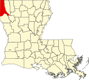
This is intended to be a complete list of the properties and districts on the National Register of Historic Places in Caddo Parish, Louisiana, United States. The locations of National Register properties and districts for which the latitude and longitude coordinates are included below, may be seen in a map. [1]

There are 68 properties and districts listed on the National Register in the parish, including 2 National Historic Landmarks. Four properties were once listed, but have since been removed. One listing, the Caddo Parish Confederate Monument, was originally listed in Caddo Parish but has since been relocated to De Soto Parish.


    This National Park Service list is complete through NPS recent listings posted March 8, 2024. [2]

Current listings

[3] Name on the Register [4] ImageDate listed [5] Location City or townDescription
1 Antioch Baptist Church
Antioch Baptist Church Antioch Baptist Church Shreveport.JPG
Antioch Baptist Church
November 1, 1982
(#82000431)
1057 Texas Avenue
32°30′14″N93°45′13″W / 32.50388°N 93.75366°W / 32.50388; -93.75366 (Antioch Baptist Church)
Shreveport Also contributing property of St. Paul's Bottoms historic district since its boundary increase on July 9, 1999. [6]
2 B'Nai Zion Temple
B'Nai Zion Temple B'Nai Zion Temple (1 of 1).jpg
B'Nai Zion Temple
January 21, 1994
(#93001547)
802 Cotton Street
32°30′30″N93°45′02″W / 32.50846°N 93.75056°W / 32.50846; -93.75056 (B'Nai Zion Temple)
Shreveport Also contributing property of Shreveport Commercial Historic District since its first boundary increase on May 16, 1997. [7]
3 Bethune Junior-Senior High School February 21, 2018
(#100002113)
4331 Henry Street
32°27′50″N93°48′44″W / 32.46378°N 93.81231°W / 32.46378; -93.81231 (Bethune Junior-Senior High School)
Shreveport Part of Caddo Parish Public School System Building Program, 1946-1961 MPS. [8]
4 C. E. Byrd High School
C. E. Byrd High School C.E. Byrd High School IMG 1585.JPG
C. E. Byrd High School
June 10, 1991
(#91000704)
3201 Line Avenue
32°28′49″N93°44′43″W / 32.48031°N 93.74541°W / 32.48031; -93.74541 (C. E. Byrd High School)
Shreveport
5 Caddo Lake Bridge
Caddo Lake Bridge Caddo Lake Bridge (1 of 1).jpg
Caddo Lake Bridge
October 18, 1996
(#96001166)
Across Caddo Lake, next modern LA 538 bridge
32°41′47″N93°57′28″W / 32.69628°N 93.95785°W / 32.69628; -93.95785 (Caddo Lake Bridge)
Mooringsport
6 Caspiana House
Caspiana House Caspiana House at LSU-S IMG 1560.JPG
Caspiana House
December 10, 1981
(#81000288)
Pioneer Heritage Center, Louisiana State University campus
32°25′52″N93°42′11″W / 32.43117°N 93.70318°W / 32.43117; -93.70318 (Caspiana House)
Shreveport Once was part of the Caspiana Plantation in Caspiana, Caddo Parish. [9]
7 Central Fire Station
Central Fire Station Central Fire Station (1 of 1).jpg
Central Fire Station
May 28, 1991
(#91000625)
801 Crockett Street
32°30′32″N93°45′03″W / 32.50881°N 93.75092°W / 32.50881; -93.75092 (Central Fire Station)
Shreveport Now hosting the Shreveport Regional Arts Council. Also contributing property of Shreveport Commercial Historic District since its first boundary increase on May 16, 1997. [7]
8 Central High School
Central High School Old Central High School, Shreveport, LA.JPG
Central High School
May 16, 1991
(#91000606)
1627 Weinstock Street
32°30′02″N93°45′51″W / 32.50043°N 93.76424°W / 32.50043; -93.76424 (Central High School)
Shreveport Also known as Central Elementary School
9 Central Railroad Station
Central Railroad Station Central Railroad Station, Shreveport, LA.JPG
Central Railroad Station
May 28, 1991
(#91000622)
1025 Marshall Street
32°30′32″N93°44′43″W / 32.50878°N 93.74526°W / 32.50878; -93.74526 (Central Railroad Station)
Shreveport Also contributing property of Shreveport Commercial Historic District since its second boundary increase on April 29, 2015. [7]
10 Crystal Grocery
Crystal Grocery Crystal Grocery (1 of 1).jpg
Crystal Grocery
March 5, 1998
(#98000181)
1124 Fairfield Avenue
32°30′12″N93°45′02″W / 32.50322°N 93.75057°W / 32.50322; -93.75057 (Crystal Grocery)
Shreveport Also known as Fertitta's Delicatessen.
11 Davidson House
Davidson House Davidson House (1 of 1).jpg
Davidson House
December 22, 1983
(#83003604)
654 Wichita Street
32°29′41″N93°44′37″W / 32.49475°N 93.74363°W / 32.49475; -93.74363 (Davidson House)
Shreveport Also contributing property of Highland Historic District. [10]
12 Dodd College President's Home
Dodd College President's Home Dodd College President's House.JPG
Dodd College President's Home
July 22, 1982
(#82002758)
601 Ockley Drive
32°28′07″N93°44′32″W / 32.46848°N 93.74228°W / 32.46848; -93.74228 (Dodd College President's Home)
Shreveport
13 Dunn House
Dunn House Closeup of the Dunn House, located in Greenwood, LA.JPG
Dunn House
December 2, 1998
(#98001423)
9371 Greenwood Road
32°26′36″N93°58′29″W / 32.44327°N 93.97474°W / 32.44327; -93.97474 (Dunn House)
Greenwood
14 Fair Park High School
Fair Park High School Fair Park High School IMG 1352.JPG
Fair Park High School
January 11, 2001
(#00001630)
3222 Greenwood Road
32°28′45″N93°47′26″W / 32.47913°N 93.79065°W / 32.47913; -93.79065 (Fair Park High School)
Shreveport
15 The Fairfield Building September 17, 2013
(#13000729)
1600-1612 Fairfield Avenue
32°29′49″N93°45′10″W / 32.49687°N 93.75276°W / 32.49687; -93.75276 (The Fairfield Building)
Shreveport
16 Fairfield Historic District
Fairfield Historic District Fairfield Historic District, LA.png
Fairfield Historic District
February 19, 1987
(#87000190)
Fairfield Avenue and adjacent streets, from Olive Street to Kings Highway
32°29′12″N93°44′59″W / 32.48674°N 93.74969°W / 32.48674; -93.74969 (Fairfield Historic District)
Shreveport The 120.6 acres (48.8 ha) historic district comprises 253 contributing properties built between 1900 and 1936. On October 24, 1996, an additional property located at 948 Boulevard Street increased district boundaries. [11]
17 First Presbyterian Church
First Presbyterian Church First Presbyterian Church Shreveport (1 of 1).jpg
First Presbyterian Church
June 15, 2011
(#11000358)
900 Jordan Street
32°29′55″N93°44′56″W / 32.49861°N 93.749°W / 32.49861; -93.749 (First Presbyterian Church)
Shreveport
18 Flesch House
Flesch House Flesch House.JPG
Flesch House
June 10, 1991
(#91000703)
415 Sherwood Road
32°27′09″N93°44′18″W / 32.45261°N 93.73828°W / 32.45261; -93.73828 (Flesch House)
Shreveport
19 Flournoy-Wise House
Flournoy-Wise House Closeup of the Flournoy-Wise House, located in Greenwood, LA.JPG
Flournoy-Wise House
March 16, 1990
(#90000435)
9251 Bois d'Arc Lane
32°26′30″N93°58′38″W / 32.44175°N 93.97717°W / 32.44175; -93.97717 (Flournoy-Wise House)
Greenwood Originally at 9152 Bois d'Arc Lane.
20 Forest Home October 30, 1989
(#89001873)
About 240 yards (220 m) west of Johns Road and Johns Gin Road intersection
32°12′29″N94°01′31″W / 32.20817°N 94.02527°W / 32.20817; -94.02527 (Forest Home)
Four Forks
21 Highland Historic District
Highland Historic District Eglin House in Shreveport IMG 1571.JPG
Highland Historic District
February 19, 1987
(#87000192)
Roughly bounded by Vine Street, Gilbert Drive, and Topeka Street and Irving Place; also roughly bounded by Stoner Avenue, Centenary Boulevard, Kings Highway, and Line Avenue
32°29′30″N93°44′23″W / 32.49168°N 93.73961°W / 32.49168; -93.73961 (Highland Historic District)
Shreveport The 96.8 acres (39.2 ha) historic district comprises 251 contributing properties built between c.1890 and 1933. Second set of boundaries represents an increase of April 17, 2001. [12]
22 Holy Trinity Catholic Church
Holy Trinity Catholic Church Holy Trinity Catholic Church Shreveport.JPG
Holy Trinity Catholic Church
September 27, 1984
(#84001261)
315 Marshall Street
32°30′52″N93°45′03″W / 32.51447°N 93.75083°W / 32.51447; -93.75083 (Holy Trinity Catholic Church)
Shreveport Also contributing property of Shreveport Commercial Historic District since its second boundary increase on April 29, 2015. [7]
23 Walter B. Jacobs House September 19, 2016
(#16000670)
5935 East Ridge Drive
32°27′09″N93°44′04″W / 32.45246°N 93.7345°W / 32.45246; -93.7345 (Walter B. Jacobs House)
Shreveport
24 Jefferson Hotel July 27, 1989
(#89000977)
907 Louisiana Avenue
32°30′30″N93°44′52″W / 32.50822°N 93.74787°W / 32.50822; -93.74787 (Jefferson Hotel)
Shreveport Also contributing property of Shreveport Commercial Historic District since its first boundary increase on May 16, 1997. [7]
25 Kansas City Southern Depot
Kansas City Southern Depot VivianStation1.JPG
Kansas City Southern Depot
January 20, 1995
(#94001578)
100 North West Front Street
32°52′19″N93°59′07″W / 32.872°N 93.98525°W / 32.872; -93.98525 (Kansas City Southern Depot)
Vivian
26 Kansas City Southern Railroad Bridge, Cross Bayou
Kansas City Southern Railroad Bridge, Cross Bayou KCS bridge Cross Bayou.jpg
Kansas City Southern Railroad Bridge, Cross Bayou
March 23, 1995
(#95000347)
Over Cross Bayou, between North Spring Street bridge and Clyde Fant Memorial Parkway bridge
32°31′10″N93°45′00″W / 32.51958°N 93.74996°W / 32.51958; -93.74996 (Kansas City Southern Railroad Bridge, Cross Bayou)
Shreveport
27 Kings Highway Christian Church
Kings Highway Christian Church Kings Highway Christian Church Shreveport.JPG
Kings Highway Christian Church
August 7, 1989
(#89001042)
806 Kings Highway
32°28′54″N93°44′48″W / 32.48172°N 93.74658°W / 32.48172; -93.74658 (Kings Highway Christian Church)
Shreveport
28 Lakeside Municipal Golf Course
Lakeside Municipal Golf Course Lakeside Municipal Golf Course, Shreveport, LA.JPG
Lakeside Municipal Golf Course
June 1, 2005
(#05000504)
2200 Milam Street
32°30′19″N93°46′40″W / 32.5053°N 93.77769°W / 32.5053; -93.77769 (Lakeside Municipal Golf Course)
Shreveport The historic golf course comprises a 38 acres (15 ha) area at northeast corner of Hearne Avenue and Milam Street.
29 Lewis House
Lewis House Lewis House (1 of 1).jpg
Lewis House
July 27, 1979
(#79001054)
675 Jordan Street
32°29′53″N93°44′40″W / 32.49793°N 93.74431°W / 32.49793; -93.74431 (Lewis House)
Shreveport Also contributing property of Highland Historic District. [10]
30 Col. Robert H. Lindsay House July 16, 1973
(#73000861)
2803 Woodlawn Avenue
32°29′04″N93°43′45″W / 32.48456°N 93.72929°W / 32.48456; -93.72929 (Col. Robert H. Lindsay House)
Shreveport Also known as Symphony House and Scofield House.
31 Line Avenue School
Line Avenue School Line Avenue School (1 of 1).jpg
Line Avenue School
June 3, 1981
(#81000289)
1800 Line Avenue
32°29′39″N93°44′47″W / 32.49419°N 93.74643°W / 32.49419; -93.74643 (Line Avenue School)
Shreveport Building now host Northwestern State University nursing campus.
32 Huey P. Long House
Huey P. Long House Huey P. Long House.JPG
Huey P. Long House
August 15, 1991
(#91001060)
305 Forest Avenue
32°28′47″N93°44′11″W / 32.47967°N 93.73637°W / 32.47967; -93.73637 (Huey P. Long House)
Shreveport
33 Louisiana State Exhibit Building
Louisiana State Exhibit Building Louisiana State Exhibit Building.JPG
Louisiana State Exhibit Building
February 20, 1991
(#91000071)
3015 Greenwood Road
32°28′48″N93°47′06″W / 32.48012°N 93.78512°W / 32.48012; -93.78512 (Louisiana State Exhibit Building)
Shreveport
34 Mason House May 22, 2001
(#01000512)
103 Ardmore Avenue
32°28′38″N93°43′06″W / 32.47733°N 93.71826°W / 32.47733; -93.71826 (Mason House)
Shreveport
35 Masonic Temple
Masonic Temple Masonic Temple (1 of 1).jpg
Masonic Temple
June 10, 1991
(#91000702)
1805 Creswell Avenue
32°29′39″N93°44′29″W / 32.49423°N 93.74132°W / 32.49423; -93.74132 (Masonic Temple)
Shreveport Also contributing property of Highland Historic District. [10]
36 Mooringsport Masonic Lodge October 10, 2023
(#100009426)
144 West Croom St.
32°41′32″N93°57′36″W / 32.6922°N 93.9601°W / 32.6922; -93.9601 (Mooringsport Masonic Lodge)
Mooringsport
37 Mooringsport School
Mooringsport School Mooringsport School (1 of 1).jpg
Mooringsport School
June 13, 1996
(#96000605)
602 Latimer Street
32°41′14″N93°57′37″W / 32.68719°N 93.96039°W / 32.68719; -93.96039 (Mooringsport School)
Mooringsport Also known as Mooringsport Elementary School.
38 Oakland Cemetery
Oakland Cemetery Oakland Cemetery (1 of 1).jpg
Oakland Cemetery
July 13, 1977
(#77000667)
Bounded by Milam Street, Christian Street and Sprague Street
32°30′31″N93°45′17″W / 32.50849°N 93.75469°W / 32.50849; -93.75469 (Oakland Cemetery)
Shreveport Post NRHP source available through wikilibrary: Newberry, Jane Leslie "Oakland Cemetery: Its Trials and tribulations; The Evolution of a National Historic Landmark" 19 (Spring/Summer 1988) North Louisiana Historical Association Journal pp 69-77
39 Ogilvie Hardware Company Building October 12, 2000
(#00001210)
217 Jones Street
32°30′33″N93°44′32″W / 32.50919°N 93.74217°W / 32.50919; -93.74217 (Ogilvie Hardware Company Building)
Shreveport Converted to 90 loft-style apartments in 2011, while preserving the historic building. [13]
40 Oil City School
Oil City School Oil City (LA) Magnet School 1.jpg
Oil City School
August 2, 2017
(#100001429)
407 North Kerley Avenue
32°44′54″N93°58′15″W / 32.7484°N 93.97081°W / 32.7484; -93.97081 (Oil City School)
Oil City Also known as Oil City Elementary Middle Magnet School, the 6 acres (2.4 ha) area comprises three historic buildings (Elementary School, High School and Gym/Cafeteria) and one historic site (Football/Baseball Field). [14]
41 Old Commercial National Bank Building
Old Commercial National Bank Building Old Commercial National Bank Building (1 of 1).jpg
Old Commercial National Bank Building
March 11, 1982
(#82002759)
509 Market Street
32°30′51″N93°44′51″W / 32.51423°N 93.74737°W / 32.51423; -93.74737 (Old Commercial National Bank Building)
Shreveport Also known as the United Mercantile Bank Building. Built in 1910. Not to be confused with nearby 1938-39 building at the corner of Edward Street and Texas Street. Also contributing property of Shreveport Commercial Historic District since its creation on March 11, 1982. [7]
42 Petroleum Tower
Petroleum Tower Petroleum Tower (1 of 1).jpg
Petroleum Tower
September 17, 2013
(#13000730)
425 Edwards Street
32°30′50″N93°44′56″W / 32.51396°N 93.74884°W / 32.51396; -93.74884 (Petroleum Tower)
Shreveport Also contributing property of Shreveport Commercial Historic District since its creation on March 11, 1982. [7]
43 St. Mark's Episcopal Church
St. Mark's Episcopal Church St. Marks Church (1 of 1).jpg
St. Mark's Episcopal Church
June 11, 1991
(#91000700)
875 Cotton Street
32°30′25″N93°45′05″W / 32.50703°N 93.75139°W / 32.50703; -93.75139 (St. Mark's Episcopal Church)
Shreveport Now known as Church of the Holy Cross. Also contributing property of Shreveport Commercial Historic District since its first boundary increase on May 16, 1997. [7]
44 St. Paul's Bottoms
St. Paul's Bottoms St. Paul's Bottoms, LA.png
St. Paul's Bottoms
October 11, 1984
(#84000033)
Roughly bounded by North Western Avenue, North Pierre Avenue, Alston Street, Christian Street, Oakland Street, Snow Street, Texas Avenue and Milam Street
32°30′26″N93°45′28″W / 32.50736°N 93.75769°W / 32.50736; -93.75769 (St. Paul's Bottoms)
Shreveport Also known as Ledbetter Heights. The 134 acres (54 ha) area comprises a total of 792 contributing properties built between c.1880 and c.1934. A boundary increase, including 17 other contributing properties located on Texas Avenue and Milam Street, took place on July 9, 1999. [15]
45 Scottish Rite Cathedral
Scottish Rite Cathedral Scottish Rite Cathedral (1 of 1).jpg
Scottish Rite Cathedral
November 6, 1986
(#86003132)
725 Cotton Street
32°30′30″N93°44′59″W / 32.50827°N 93.74967°W / 32.50827; -93.74967 (Scottish Rite Cathedral)
Shreveport Also contributing property of Shreveport Commercial Historic District since its first boundary increase on May 16, 1997. [7]
46 Shreveport Commercial Historic District
Shreveport Commercial Historic District Downtown Riverfront, Shreveport, LA, USA - panoramio.jpg
Shreveport Commercial Historic District
March 11, 1982
(#82002760)
Roughly bounded by Commerce Street, Crockett Street, Market Street, Franklin Street, Lake Street, Commons Street, Elvis Presley Avenue, Douglas Street, Travis Street, Marshall Street and Fannin Street
32°30′43″N93°44′59″W / 32.51206°N 93.74978°W / 32.51206; -93.74978 (Shreveport Commercial Historic District)
Shreveport Also known as Downtown Shreveport Historic District. The 145 acres (59 ha) area comprises a total of 181 contributing properties. A first boundary increase took place on May 16, 1997, and a subsequent modification was made on April 29, 2015. [16] [17]
47 Shreveport Fire Station No. 8
Shreveport Fire Station No. 8 Shreveport Fire Station No. 8.JPG
Shreveport Fire Station No. 8
June 30, 2000
(#00000683)
3406 Velva Avenue
32°28′49″N93°46′54″W / 32.48024°N 93.78161°W / 32.48024; -93.78161 (Shreveport Fire Station No. 8)
Shreveport
48 Shreveport Municipal Building
Shreveport Municipal Building Construction Outside 724 McNeill Street, Shreveport.JPG
Shreveport Municipal Building
May 5, 1982
(#82002761)
724 McNeil Street
32°30′35″N93°44′55″W / 32.50981°N 93.74861°W / 32.50981; -93.74861 (Shreveport Municipal Building)
Shreveport Also contributing property of Shreveport Commercial Historic District since its first boundary increase on May 16, 1997. [7]
49 Shreveport Municipal Memorial Auditorium
Shreveport Municipal Memorial Auditorium Shreveport-municipal-auditorium-1995.jpg
Shreveport Municipal Memorial Auditorium
May 28, 1991
(#91000624)
705 Elvis Presley Boulevard
32°30′29″N93°45′11″W / 32.50793°N 93.75296°W / 32.50793; -93.75296 (Shreveport Municipal Memorial Auditorium)
Shreveport Also contributing property of Shreveport Commercial Historic District since its first boundary increase on May 16, 1997. [7]
50 Shreveport Water Works Company, Pump Station
Shreveport Water Works Company, Pump Station McNeil Street Pumping Station, McNeil Street & Cross Bayou, Shreveport (Caddo Parish, Louisiana).jpg
Shreveport Water Works Company, Pump Station
May 9, 1980
(#80001707)
142 North Common Street
32°31′04″N93°45′26″W / 32.51769°N 93.7571°W / 32.51769; -93.7571 (Shreveport Water Works Company, Pump Station)
Shreveport
51 Shreveport Woman's Department Club Building
Shreveport Woman's Department Club Building Shreveport Woman's Department Club Building (1 of 1).jpg
Shreveport Woman's Department Club Building
July 18, 1985
(#85001590)
802 Margaret Place
32°29′47″N93°44′47″W / 32.49639°N 93.74628°W / 32.49639; -93.74628 (Shreveport Woman's Department Club Building)
Shreveport
52 South Highlands Fire Station
South Highlands Fire Station South Highlands Fire Station.JPG
South Highlands Fire Station
May 28, 1991
(#91000626)
763 Oneonta Street
32°27′53″N93°44′45″W / 32.46484°N 93.74576°W / 32.46484; -93.74576 (South Highlands Fire Station)
Shreveport Also a contributing property to South Highlands Historic District
53 South Highlands Historic District
South Highlands Historic District South Highlands Historic District, LA.png
South Highlands Historic District
April 29, 1999
(#99000496)
Roughly bounded by Southern Avenue, Lawhon Street, Fairfield Avenue, Trabue Street, Unadilla Street, Gilbert Drive, Oneonta Street, Line Avenue, Thora Boulevard, Thornhill Avenue, Delmar Street and Southfield Road
32°27′50″N93°44′54″W / 32.46385°N 93.74824°W / 32.46385; -93.74824 (South Highlands Historic District)
Shreveport The 188 acres (76 ha) area comprises a total of 394 contributing properties built between 1912 and 1949. [18] [19]
54 Star Cemetery
Star Cemetery Star Cemetery1, Shreveport, LA.JPG
Star Cemetery
January 17, 2002
(#01001478)
West of St. Joseph Cemetery, access entrance in front of 2205 Texas Avenue
32°29′26″N93°46′09″W / 32.49069°N 93.76907°W / 32.49069; -93.76907 (Star Cemetery)
Shreveport
55 A. C. Steere Elementary School February 20, 1991
(#91000074)
4009 Youree Drive
32°28′01″N93°43′18″W / 32.46687°N 93.72163°W / 32.46687; -93.72163 (A. C. Steere Elementary School)
Shreveport
56 Strand Theatre
Strand Theatre Strand (1 of 1).jpg
Strand Theatre
May 26, 1977
(#77000668)
630 Crockett Street
32°30′37″N93°45′00″W / 32.51022°N 93.74992°W / 32.51022; -93.74992 (Strand Theatre)
Shreveport Also contributing property of Shreveport Commercial Historic District since its first boundary increase on May 16, 1997. [7]
57 Tally's Bank July 14, 1976
(#76000963)
525 Spring Street
32°30′52″N93°44′46″W / 32.51443°N 93.746°W / 32.51443; -93.746 (Tally's Bank)
Shreveport Also contributing property of Shreveport Commercial Historic District since its creation on March 11, 1982. [7]
58 Taylor Wholesale Grocers and Cotton Factors Warehouse-Lee Hardware Building February 13, 1986
(#86000251)
719-729 Edwards Street
32°30′42″N93°44′47″W / 32.51156°N 93.74632°W / 32.51156; -93.74632 (Taylor Wholesale Grocers and Cotton Factors Warehouse-Lee Hardware Building)
Shreveport Now known as Lee Hardware, building is also a contributing property of Shreveport Commercial Historic District since its first boundary increase on May 16, 1997. [7]
59 Texas Avenue Buildings
Texas Avenue Buildings Texas Avenue Buildings (1 of 1).jpg
Texas Avenue Buildings
May 25, 1979
(#79001055)
824-874 Texas Avenue
32°30′31″N93°45′07″W / 32.50854°N 93.75198°W / 32.50854; -93.75198 (Texas Avenue Buildings)
Shreveport All the district buildings became contributing properties of Shreveport Commercial Historic District since its first boundary increase on May 16, 1997. [7]
60 Thrasher House September 10, 1987
(#87001565)
Pioneer Heritage Center, Louisiana State University campus
32°25′53″N93°42′12″W / 32.43134°N 93.70342°W / 32.43134; -93.70342 (Thrasher House)
Shreveport
61 Trees City Office and Bank Building
Trees City Office and Bank Building Treescity3.JPG
Trees City Office and Bank Building
August 13, 1986
(#86001492)
200 South Land Avenue
32°44′28″N93°58′16″W / 32.7412°N 93.97098°W / 32.7412; -93.97098 (Trees City Office and Bank Building)
Oil City
62 Trosper House
Trosper House Closeup of the Trospher House, located in Greenwood, LA.JPG
Trosper House
May 14, 1987
(#87000728)
7078 Magnolia Street
32°26′29″N93°58′35″W / 32.44126°N 93.97632°W / 32.44126; -93.97632 (Trosper House)
Greenwood
63 U.S. Post Office and Courthouse
U.S. Post Office and Courthouse Caddo Parish Library IMG 1328.JPG
U.S. Post Office and Courthouse
September 12, 1974
(#74000920)
424 Texas Street
32°30′48″N93°44′59″W / 32.51331°N 93.7497°W / 32.51331; -93.7497 (U.S. Post Office and Courthouse)
Shreveport Also contributing property of Shreveport Commercial Historic District since its creation on March 11, 1982. [7]
64 Booker T. Washington High School July 14, 2015
(#15000414)
2104 Milam Street
32°30′19″N93°46′26″W / 32.5053°N 93.77375°W / 32.5053; -93.77375 (Booker T. Washington High School)
Shreveport
65 Samuel Wiener House
Samuel Wiener House Samuel Wiener House.JPG
Samuel Wiener House
September 30, 2004
(#04001079)
615 Longleaf Road
32°28′03″N93°44′33″W / 32.46749°N 93.74247°W / 32.46749; -93.74247 (Samuel Wiener House)
Shreveport
66 Wile House
Wile House Wile House.JPG
Wile House
August 5, 1991
(#91001007)
626 Wilder Place
32°28′35″N93°44′35″W / 32.4764°N 93.74295°W / 32.4764; -93.74295 (Wile House)
Shreveport
67 Wray-Dickinson Building March 24, 1983
(#83000492)
308 Market Street
32°30′56″N93°44′58″W / 32.51543°N 93.7494°W / 32.51543; -93.7494 (Wray-Dickinson Building)
Shreveport Also contributing property of Shreveport Commercial Historic District since its second boundary increase on April 29, 2015. [7]
68 YMCA, Downtown Branch
YMCA, Downtown Branch YMCA Branch (1 of 1).jpg
YMCA, Downtown Branch
May 28, 1991
(#91000621)
400 McNeill Street
32°30′46″N93°45′05″W / 32.51264°N 93.75151°W / 32.51264; -93.75151 (YMCA, Downtown Branch)
Shreveport Also contributing property of Shreveport Commercial Historic District since its first boundary increase on May 16, 1997. [7]

Former listings

[3] Name on the RegisterImageDate listedDate removedLocationCity or townDescription
1 C.C. Antoine House
C.C. Antoine House C.C. Antoine House (1 of 1).jpg
C.C. Antoine House
August 20, 1999
(#99001013)
March 13, 20241941 Perrin Street
32°30′35″N93°46′15″W / 32.50966°N 93.77096°W / 32.50966; -93.77096 (C.C. Antoine House)
Shreveport 
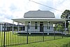
In April 2007 a move of the property to a public park at corner of Sycamore Avenue and Milam Street was pre-approved, but never took place. Destroyed by fire in May 2022. [20] [21]
2 Sidney Herold Mansion July 25, 1978
(#78003197)
August 2, 1978840 Jordan Street
32°29′56″N93°44′51″W / 32.49893°N 93.74757°W / 32.49893; -93.74757 (Sidney Herold Mansion)
Shreveport Removed from the register due to owner objection. Demolished later in 1978.
3 Huey P. Long House
Huey P. Long House 2403 Laurel St. Shreveport, LA.JPG
Huey P. Long House
June 10, 1991
(#91000701)
May 2, 20162403 Laurel Street
32°29′43″N93°46′36″W / 32.49537°N 93.77679°W / 32.49537; -93.77679 (Huey P. Long House)
Shreveport Destroyed by fire in September 1992. [22]
4 Sprague Street Houses October 3, 1983
(#83003606)
January 31, 20191100-1118 Sprague Street
32°30′32″N93°45′21″W / 32.50889°N 93.75595°W / 32.50889; -93.75595 (Sprague Street Houses)
Shreveport All houses have been demolished. The last one, at 1118 Sprague Street, on the corner of Christian Street, was torn down in early 2017. [23] [24]

See also

Related Research Articles

<span class="mw-page-title-main">National Register of Historic Places listings in East Baton Rouge Parish, Louisiana</span>

This is a list of the National Register of Historic Places listings in East Baton Rouge Parish, Louisiana.

<span class="mw-page-title-main">National Register of Historic Places listings in Iberia Parish, Louisiana</span>

This is a list of the National Register of Historic Places listings in Iberia Parish, Louisiana.

<span class="mw-page-title-main">National Register of Historic Places listings in DeSoto Parish, Louisiana</span>

This is a list of the National Register of Historic Places listings in DeSoto Parish, Louisiana.

<span class="mw-page-title-main">National Register of Historic Places listings in Lafayette Parish, Louisiana</span>

This is a list of the National Register of Historic Places listings in Lafayette Parish, Louisiana.

<span class="mw-page-title-main">National Register of Historic Places listings in Lincoln Parish, Louisiana</span>

This is a list of the National Register of Historic Places listings in Lincoln Parish, Louisiana.

<span class="mw-page-title-main">National Register of Historic Places listings in Avoyelles Parish, Louisiana</span>

This is a list of the National Register of Historic Places listings in Avoyelles Parish, Louisiana.

<span class="mw-page-title-main">National Register of Historic Places listings in Iberville Parish, Louisiana</span>

This is a list of the National Register of Historic Places listings in Iberville Parish, Louisiana.

<span class="mw-page-title-main">Shreveport Municipal Memorial Auditorium</span> Theater and meeting hall in Shreveport, Louisiana, United States

Shreveport Municipal Memorial Auditorium is a historic performance and meeting venue at 705 Elvis Presley Boulevard in Shreveport, Louisiana. It is an Art Deco building constructed between 1926 and 1929 during the administration of Mayor Lee Emmett Thomas as a memorial to the servicemen of World War I. In 1991, the auditorium was listed on the National Register of Historic Places and on October 6, 2008, it was designated a National Historic Landmark.

The Jefferson Hotel in Shreveport, Louisiana is a four-story brick railway hotel that was built in 1922. It was listed on the National Register of Historic Places in 1989. It also became a contributing property of Shreveport Commercial Historic District when its boundaries were increased on May 16, 1997.

<span class="mw-page-title-main">Holy Trinity Catholic Church (Shreveport, Louisiana)</span> Historic church in Louisiana, United States

Holy Trinity Catholic Church in Shreveport, Louisiana was built in 1896. It was listed on the National Register of Historic Places in 1984. The current structure is the third church, with the first being constructed in 1856 by Fr. Jean Pierre, who became the first pastor. During the city's Yellow Fever epidemic of 1873, Fr. Jean Pierre and his assistant pastor, Fr. Isidore Quemerais, both gave their lives while caring for the sick and dying.

<span class="mw-page-title-main">National Register of Historic Places listings in Calcasieu Parish, Louisiana</span>

This is a list of the National Register of Historic Places listings in Calcasieu Parish, Louisiana.

<span class="mw-page-title-main">National Register of Historic Places listings in Jefferson Parish, Louisiana</span>

This is a list of the National Register of Historic Places listings in Jefferson Parish, Louisiana.

<span class="mw-page-title-main">National Register of Historic Places listings in Jefferson Davis Parish, Louisiana</span>

This is a list of the National Register of Historic Places listings in Jefferson Davis Parish, Louisiana.

<span class="mw-page-title-main">National Register of Historic Places listings in Franklin Parish, Louisiana</span>

This is a list of the National Register of Historic Places listings in Franklin Parish, Louisiana.

<span class="mw-page-title-main">National Register of Historic Places listings in East Carroll Parish, Louisiana</span>

This is a list of the National Register of Historic Places listings in East Carroll Parish, Louisiana.

<span class="mw-page-title-main">United States Post Office and Courthouse (Shreveport, Louisiana)</span> United States historic place

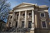
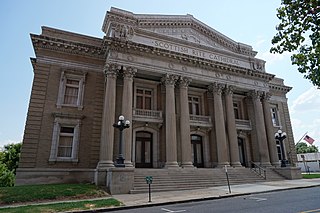
The U.S. Post Office and Courthouse in Shreveport, Louisiana, was built in 1910. It was designed in Italian Renaissance architecture style by James K. Taylor and James A. Wetmore. It served historically as a courthouse and as a post office.

<span class="mw-page-title-main">National Register of Historic Places listings in Claiborne Parish, Louisiana</span>

This is a list of the National Register of Historic Places listings in Claiborne Parish, Louisiana.

<span class="mw-page-title-main">Scottish Rite Cathedral (Shreveport, Louisiana)</span> United States historic place

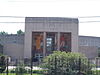
The Scottish Rite Cathedral is a historic building located at 725 Cotton Street in Shreveport, Louisiana. It was designed in 1915 by architect Edward F. Neild in Beaux Arts style.

<span class="mw-page-title-main">National Register of Historic Places listings in Caldwell Parish, Louisiana</span>

This is a list of the National Register of Historic Places listings in Caldwell Parish, Louisiana.

<span class="mw-page-title-main">Central Fire Station (Shreveport, Louisiana)</span> United States historic place

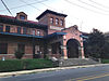
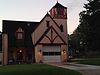
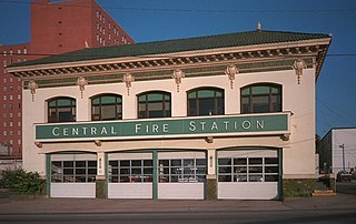
The Central Fire Station in Shreveport, Louisiana, at 801 Crockett St., was built in 1922. It was listed on the National Register of Historic Places in 1991. The listing included two contributing buildings.

References

  1. The latitude and longitude information provided in this table was derived originally from the National Register Information System, which has been found to be fairly accurate for about 99% of listings. Some locations in this table may have been corrected to current GPS standards.
  2. National Park Service, United States Department of the Interior, "National Register of Historic Places: Weekly List Actions", retrieved March 8, 2024.
  3. 1 2 Numbers represent an alphabetical ordering by significant words. Various colorings, defined here, differentiate National Historic Landmarks and historic districts from other NRHP buildings, structures, sites or objects.
  4. "National Register Information System". National Register of Historic Places . National Park Service. March 13, 2009.
  5. The eight-digit number below each date is the number assigned to each location in the National Register Information System database, which can be viewed by clicking the number.
  6. "St. Paul's Bottoms" (PDF). State of Louisiana's Division of Historic Preservation. Retrieved April 13, 2018.[ permanent dead link ]
  7. 1 2 3 4 5 6 7 8 9 10 11 12 13 14 15 16 17 18 "Shreveport Commercial Historic District" (PDF). State of Louisiana's Division of Historic Preservation. Archived from the original (PDF) on April 14, 2018. Retrieved April 16, 2018.
  8. National Register of Historic Places Program: Weekly List - February 23, 2018
  9. Otto, David (2010-08-17). Insiders' Guide to Shreveport. Rowman & Littlefield. p. 92. ISBN   978-0-7627-6340-5.
  10. 1 2 3 "Highland Historic District" (PDF). State of Louisiana's Division of Historic Preservation. Retrieved April 18, 2018.
  11. Fairfield Historic District boundary map and District boundaries on Wikimedia Commons
  12. Highland Historic District boundary map and District boundaries on Wikimedia Commons
  13. Provident Realty Advisors. "The Ogilvie Hardware Lofts" . Retrieved April 13, 2018.
  14. "Oil City School" (PDF). State of Louisiana's Division of Historic Preservation. Retrieved April 13, 2018. (with 63 photos and two maps)
  15. St. Paul's Bottoms boundary map, St. Paul's Bottoms boundary map image and District boundaries on Wikimedia Commons
  16. "Shreveport Commercial Historic District" (PDF). State of Louisiana's Division of Historic Preservation. Archived from the original (PDF) on April 14, 2018. Retrieved April 13, 2018. (with 66 photos and four maps)
  17. Shreveport Commercial Historic District boundary map and District boundaries on Wikimedia Commons
  18. "South Highlands Historic District" (PDF). State of Louisiana's Division of Historic Preservation. Retrieved April 17, 2018. (with fifteen photos and two maps)
  19. South Highlands Historic District boundary map and District boundaries on Wikimedia Commons
  20. "Shreveport's C.C. Antoine House destroyed by fire".
  21. National Register Staff (June 1999). "National Register of Historic Places Registration Form: C.C. Antoine House". National Park Service. pp. 10–15. Retrieved April 10, 2018..
  22. "National Register of Historic Places: Request for Removal - Huey P. Long House" (PDF). National Park Service. March 18, 2016. Retrieved April 18, 2018.
  23. Gerry May (April 13, 2017). "Historians lament demolition of last historic home on Sprague Row". ktbs.com. Retrieved April 18, 2018.
  24. The last Sprague Street house, still standing in 2013 and 2014, is visible on StreetView and satellite imagery.