
Fresnillo is a city in north central Mexico, founded in 1554 by Francisco de Ibarra. It is the second largest city in Zacatecas state and the seat of Fresnillo municipality. As a rail and highway junction, Fresnillo is the center of a rich mining area known especially for silver, and the location of one of the world's richest silver mines, the Mina Proaño or Fresnillo Mine, which belongs to the Peñoles mining company. Other important economic activities include agriculture, cattle raising, and a mining school. Fresnillo is also the municipal seat of the municipality of the same name which surrounds it. The municipality had a population of 196,538 and an areal extent of 4,947 square kilometres (1,910 sq mi).

Loreto is a town and municipality in the state of Zacatecas, Mexico. The town is the seventh-largest community in the state, with a 2005 census population of 22,085 inhabitants, while the municipality of which it serves as municipal seat had a population of 43,411. The municipality has an area of 427 km².
Tingüindín is a municipality in the Mexican state of Michoacán. The municipality has an area of 174.24 square kilometres and is bordered to the north by the municipalities of Villamar, Tangamandapio and Tangancícuaro, to the east by Los Reyes, and to the south and west by Tocumbo. The municipality had a population of 12,414 inhabitants according to the 2005 census. Its municipal seat is the city of the same name.

The municipality of Tepechitlán is located in the southwestern portion of the Mexican state of Zacatecas. It is located between 21º33'49" and 21º44'00" latitude north and 103º09'07" and 103º32'01" longitude west with an average altitude of approximately 1700 meters above sea level. The municipality covers an area of 584 square kilometers.
Benito Juárez is a municipality located on the edge of the Canyon of Tlaltenango in the southern extreme of the Mexican state of Zacatecas. The municipal seat is the town of Florencia.

García is a city and municipality located to the northwest of the Monterrey metropolitan area in the state of Nuevo León, Mexico. The municipality had, according to the 2005 census, a population of 145,867. It borders the municipalities of Mina, Escobedo and Hidalgo to the north; to the south and east with Santa Catarina; and to the west with the state of Coahuila.
Apulco is a city in the Mexican state of Zacatecas. The city serves as the administrative center for the surrounding municipality of Apulco. Apulco had a 2005 census population of 1,453 people.
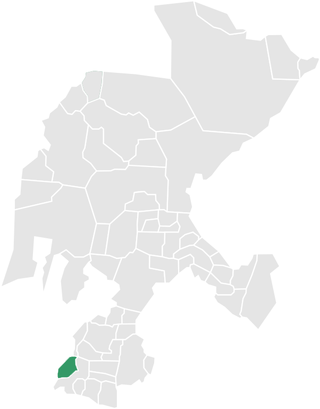
Apulco is one of the 58 municipalities in the Mexican state of Zacatecas. It is located on the southern part of the state of Zacatecas and it is bounded by the municipality of Nochistlán de Mejía. The municipality covers a total surface area of 200 square kilometers (77 sq mi).

Nochistlán is one of the 58 municipalities in the Mexican state of Zacatecas. Founded by the Caxcanes, it was also the first site of Guadalajara in Mexico.

Atolinga is one of the 58 municipalities in the state of Zacatecas, Mexico. It is located on the southern part of the state of Zacatecas and is bordered by the municipalities of Tepechitlán and Florencia de Benito Juárez. To the east it is bordered by Tlaltenango de Sánchez Román and to the north and west by the state of Jalisco. The municipality covers a total surface area of 280 square kilometers (110 sq mi).

Calera is one of the 58 municipalities in the Mexican state of Zacatecas. It is located on the central part of the state of Zacatecas and it is bounded by the municipalities of General Enrique Estrada, Fresnillo, Villa de Cos, Pánuco, Morelos and Zacatecas. The municipality covers a total surface area of 389 square kilometers (150 sq mi). The municipality makes up for 0.5% of the area of the state of Zacatecas.

Cañitas de Felipe Pescador is one of the 58 municipalities in the state of Zacatecas, Mexico. It is located in the northern part of Zacatecas and is bounded by the municipalities of Río Grande, Villa de Cos, and Fresnillo. The municipality covers a total surface area of 482 square kilometres (186 sq mi).

Concepción del Oro is one of the 58 municipalities in the Mexican state of Zacatecas. It is located on the northern part of the state and it is bounded by the municipalities of Mazapil and El Salvador; it also lies next to the states of Coahuila and San Luis Potosí. The municipality covers a total surface area of 2,559 square kilometers (988 sq mi).
Cuauhtémoc is one of the 58 municipalities in the Mexican state of Zacatecas. It is located in the central part of the state of Zacatecas and it is bounded by the municipalities of Ojocaliente, Luis Moya, and Genaro Codina; it also shares a border with the state of Aguascalientes. The municipality covers a total surface area of 318 square kilometers (123 sq mi).
Jungapeo is a municipality in the eastern part of the Mexican state of Michoacán. The municipality has an area of 265.98 square kilometres and is bordered to the north by the municipality of Tuxpan, to the east by Juárez and Zitácuaro, to the south by Tuzantla, and to the west by Hildago. The municipality had a population of 18,571 inhabitants according to the 2005 census. Its municipal seat is the city of Jungapeo de Juárez.
Coalcomán de Vázquez Pallares is a municipality located in the Sierra Madre del Sur mountain range, in the southwest region of the state of Michoacán in central-western Mexico.

Zacatecas ( ), officially the Free and Sovereign State of Zacatecas, is one of the 31 states of Mexico. It is divided into 58 municipalities and its capital city is Zacatecas.
General Pánfilo Natera is a municipality in the Mexican state of Zacatecas, located approximately 50 kilometres (31 mi) east of the state capital. It is named after Pánfilo Natera, commander of the Central Division of the Constitutional Army in the Mexican Revolution, and governor of Zacatecas in 1915 and from 1940 to 1944.

Santa María de la Paz is a municipality in the Mexican state of Zacatecas, located approximately 165 kilometres (103 mi) southwest of the state capital of Zacatecas City.

Juchipila is a municipality in the Mexican state of Zacatecas, located approximately 160 kilometres (99 mi) southwest of the state capital Zacatecas City.

