Chalchihuites Municipality

Last updated
Chalchihuites Municipality
Etymology: Emerald or precious stone (in Nahuatl)
Municipio de Chalchihuites.png
CountryFlag of Mexico.svg  Mexico
State Zacatecas
Municipal seat Chalchihuites
Government
  Municipal presidentLic. Laura Nava Reveles
Area
  Total891 km2 (344 sq mi)
Elevation
2,270 m (7,450 ft)
Population
  Total10,519
  Density12/km2 (31/sq mi)
Website www.chalchihuites.gob.mx

Chalchihuites is a municipality in the Mexican state of Zacatecas. The archaeological site of Altavista, at Chalchihuites, is located 137 miles to the northwest of the city of Zacatecas and 102 miles southeast of the city of Durango. Located to the west of Sombrerete in the northwestern corner of the state of Zacatecas, it is believed that the site was a cultural oasis that was occupied more or less continuously from AD 100 to AD 1400.

Contents

History

It was a Teotihuacano ceremonial center lying on the Tropic of Cancer. It has a number of important features, including petroglyphs, a processional walkway and the Hall of Columns. It has some of the best evidence for astronomical alignments at an archaeological site but remains poorly known.

The archaeologist Manuel Gamio referred to Chalchihuites as a "culture of transition" between the Mesoamerican civilizations and the so-called Chichimeca hunter-gatherers who lived in the arid plateau of central Mexico. Chalchihuites and La Quemada were both outposts of Mesoamerican settlement in an ecological and cultural frontier area. However, in this transition zone, climatic changes caused continual shifts in the available resource base, discouraging most attempts at creating permanent settlements.

It is also known for a large church that is located in its colonial center.

It founded by the Spanish captain Martin Perez in 1556 of a community from Guadalajara, in the first years after the conquest, became known as a mining center since 1591, when a group of Spaniards and Tlaxcalans were to be placed there by order of the viceroy Don Luis de Velasco. It is known that Don Lucas de Montealegre governed that colony as governor. The municipality dates from the same period as that of Sombrerete; From immemorial time it was part of the Mayor's Office of the same name, having constitutional character the year of 1824. Formerly it was called Real of Mines of the Valley of San Pedro de los Chalchihuites, they formed three districts or divisions: Chalchihuites, Tonalá and Nueva Tlaxcala, But in 1857 this last part, that belonged to Jalisco, was added to the State of Zacatecas by constitutional declaration.

Demographics

The municipality of Chalchihuites, according to the 2020 Population and Housing Census, has 10,086 inhabitants, of which 4,892 are men and 5,194 are women.

Locations

The municipality includes a total of 69 localities in its territory. The main ones, considering their population from the 2020 Census, are:

LocationPopulation
Total Municipality10 086
Chalchihuites3 816
Gualterio 826
José María Morelos (San José de Gracia)817
San José de Buenavista (San José de Abajo)357
Hidalgo del Manto337
Blue Stones303

Geography

The municipality of Chalchihuites is physically located in the Sierra Madre Occidental and Mesa Central. It has a territorial extension of approximately 891 km², and limits to the north with the municipality of Sombrerete, to the south with the municipality of Jiménez of Teúl and to the west with the State of Durango. The word Chalchihuites is of Nahuatl origin and means Emerald or precious stone. In the municipality of Chalchihuites five minutes away you will find a very beautiful place better known as Gualterio which has a hot springs spa.

Climate

The climate is very hot during the summer months and cold in the winter. The site sits lonely in the badlands about four miles east of the town of Chalchihuites. It is also close to the colonial town of Zacatecas, which has a distinctive cathedral.

Notable people

23°28′34″N103°52′50″W / 23.4761111211°N 103.880555566°W / 23.4761111211; -103.880555566

Related Research Articles

<span class="mw-page-title-main">Peñoles</span> Mexican mining company (1887–)

Peñoles is a subsidiary company owned by Grupo BAL. Peñoles is the second largest Mexican mining company, the first Mexican producer of gold, zinc and lead and the world leader in silver production. Peñoles is a company with active mines within Mexico and with some prospection projects in South America. Holdings includes the Fresnillo Silver Mine / Mina Proaño, the Met-Mex Peñoles metallurgical complex and Química del Rey; a Chemical facility; three operations. Peñoles produces about 80,500,000 troy ounces (2,500,000 kg) of silver and 756,100 troy ounces (23,520 kg) of gold annually. Other metals that the company produces are zinc, lead, copper, bismuth, and cadmium.

<span class="mw-page-title-main">Metallurgy in pre-Columbian Mesoamerica</span>

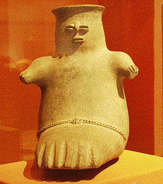
The emergence of metallurgy in pre-Columbian Mesoamerica occurred relatively late in the region's history, with distinctive works of metal apparent in West Mexico by roughly 800 CE, and perhaps as early as 600 CE. Metallurgical techniques likely diffused northward from regions in Central or South America via maritime trade routes; recipients of these metallurgical technologies apparently exploited a wide range of material, including alloys of copper-silver, copper-arsenic, copper-tin and copper-arsenic-tin.

<span class="mw-page-title-main">La Quemada</span>

La Quemada is an archeological site. It is located in the Villanueva Municipality, in the state of Zacatecas, about 56 km south of the city of Zacatecas on Fed 54 Zacatecas–Guadalajara, in Mexico.

<span class="mw-page-title-main">Camino Real de Tierra Adentro</span> Northernmost of Mexico Citys four "royal roads"

The Camino Real de Tierra Adentro, also known as the Silver Route, was a Spanish 2,560-kilometre-long (1,590 mi) road between Mexico City and San Juan Pueblo, New Mexico, that was used from 1598 to 1882. It was the northernmost of the four major "royal roads" that linked Mexico City to its major tributaries during and after the Spanish colonial era.

Ricardo Moreno Escamilla was a Mexican professional boxer in the Super Featherweight division. Moreno was ranked #76 on The Ring's list of 100 All time Greatest Punchers.

<span class="mw-page-title-main">Sombrerete, Zacatecas</span> City and municipality in Zacatecas, Mexico

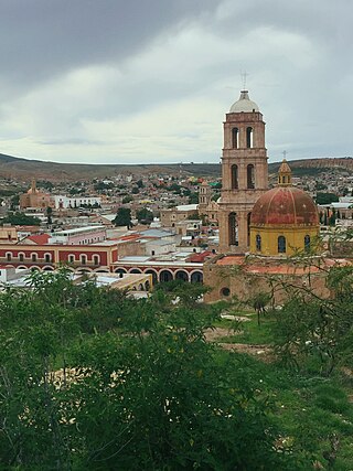
Sombrerete is a town and municipality located in the northwest of the Mexican state of Zacatecas, bordering the state of Durango.

<span class="mw-page-title-main">Peralta (Mesoamerican site)</span> Mesoamerican archaeological site in Abasolo Municipality, Guanajuato, Mexico

Peralta is a prehispanic mesoamerican archaeological site located in Abasolo Municipality, Guanajuato, just outside the village of San Jose de Peralta in the Mexican state of Guanajuato. The site is reached via Fed 90 from Irapuato. Approximately 15.5 km south of the intersection with Fed 45, take the Irapuato-Huanimaro route southeast (left). Follow the route for about 12.5 km, then turnoff southwest (right) to San Jose de Peralta. Cross the bridge and turn right, and then follow the road out of the village northwest about 1 km. The site is on the left.

<span class="mw-page-title-main">Zacatecas</span> State of Mexico

Zacatecas ( ), officially the Free and Sovereign State of Zacatecas, is one of the 31 states of Mexico. It is divided into 58 municipalities and its capital city is Zacatecas.

Súchil is a city and seat of the municipality of Súchil, in the state of Durango, north-western Mexico. As of 2010, the town of Súchil had a population of 4,107.

Juan de Tolosa was a Spanish Basque conquistador. He discovered rich silver deposits near the present day city of Zacatecas, Mexico, in 1546.

<span class="mw-page-title-main">Altavista (Zacatecas)</span>

Altavista, or Chalchihuites, is an archaeological site near the municipality of Chalchihuites in the Mexican state of Zacatecas, in the northwest of Mexico. It is believed that the site was a cultural oasis that was occupied more or less continuously from AD 100 to AD 1400.

<span class="mw-page-title-main">Chupícuaro</span>

Chupícuaro is an important prehispanic archeological site from the late preclassical or formative period. The culture that takes its name from the site dates to 400 BC to 200 AD, or alternatively 500 BC to 300 AD., although some academics suggest an origin as early as 800 BC.

<span class="mw-page-title-main">El Teúl</span>

El Teúl is an important archaeological Mesoamerican site located on a hill with the same name in the municipality of Teúl in the south of the Mexican state of Zacatecas, near the border with the state of Jalisco.

<span class="mw-page-title-main">La Ferrería</span> Archaeological site in Durango, Mexico

La Ferrería is an archaeological site located 7 kilometers south of the city of Durango, in the Mexican state of Durango, at the “Cerro de La Ferrería”, on the side of the Tunal River.

<span class="mw-page-title-main">Sierra de Órganos National Park</span>

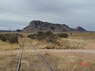
Sierra de Órganos National Park is a national park in Mexico, located in the northwest corner of the municipality of Sombrerete in the state of Zacatecas, near the border with Durango. The park is known for its diverse aridland ecosystem and towering rock formations of the Sierra Madre Occidental, which are reminiscent of organ pipe cacti or the pipes of the musical instrument, from which the park takes its name.

<span class="mw-page-title-main">Miguel Auza Municipality</span> Municipality in Zacatecas, Mexico

Miguel Auza is a municipality in the Mexican state of Zacatecas, located approximately 190 kilometres (120 mi) northwest of the state capital of Zacatecas City.

<span class="mw-page-title-main">Saín Alto Municipality</span> Municipality in Zacatecas, Mexico

Saín Alto is a municipality in the Mexican state of Zacatecas, located approximately 110 kilometres (68 mi) northwest of the state capital of Zacatecas City.

<span class="mw-page-title-main">Juchipila</span> Municipality in Zacatecas, Mexico

Juchipila is a municipality in the Mexican state of Zacatecas, located approximately 160 kilometres (99 mi) southwest of the state capital Zacatecas City.

<span class="mw-page-title-main">Gualterio, Zacatecas</span> Municipality and town in Mexico

Gualterio is a town and village in the municipality of Chalchihuites, Zacatecas. This town is located approximately two to three hours from the city of Zacatecas and approximately an hour and a half from Durango. To the northwest, it is bordered by the municipality of Súchil, to the south by the town of Chalchihuites and to the east is Sombrerete, Zacatecas.

References

  1. Dorian, Lilia (2008-06-01). "Ricardo Moreno's Video Biography". Televisa Deportes. Retrieved 2010-08-26.
  2. Luevanos, Fernando (2008-10-04). "Ricardo Moreno is one of the All time Greatest Punchers". Boxrec. Retrieved 2010-09-22.
  3. Hernández, Carlos; Jorge Sepúlveda Marin (2008-06-26). "Ricardo El Pajarito Moreno". Jornada. Retrieved 2010-09-22.
  4. Mulei, Alessandro (2006-08-26). "Members of Los Bukis". La Purísima. Retrieved 2010-09-22.
  5. Escobedo, Juan; Escobedo, Thomas. "San Juan de Los Mier". Myxer. Retrieved 2010-06-23.