
Biliran, officially the Province of Biliran, is an island province in the Philippines located in the Eastern Visayas region. Biliran is one of the country's smallest and newest provinces. Formerly a sub-province of Leyte, it became an independent province in 1992.

Atibaia is a Brazilian municipality in the state of São Paulo, Brazil. The name is derived from an indigenous language called Tupi, and means "healthy water river". Its name has changed over time, from the primitive Tupi word Tybaia, to Thibaia, Atubaia, Thibaya, and finally the city's modern name, Atibaia.

Fresnillo is a city in north central Mexico, founded in 1554 by Francisco de Ibarra. It is the second largest city in Zacatecas state and the seat of Fresnillo municipality. As a rail and highway junction, Fresnillo is the center of a rich mining area known especially for silver, and the location of one of the world's richest silver mines, the Mina Proaño or Fresnillo Mine, which belongs to the Peñoles mining company. Other important economic activities include agriculture, cattle raising, and a mining school. Fresnillo is also the municipal seat of the municipality of the same name which surrounds it. The municipality had a population of 196,538 and an areal extent of 4,947 square kilometres (1,910 sq mi).

San Mateo, officially the Municipality of San Mateo, is a 1st class urban municipality in the province of Rizal, Philippines. According to the 2020 census, it has a population of 273,306.
Rizal, officially the Municipality of Rizal, is a 5th class municipality in the province of Laguna, Philippines. According to the 2020 census, it has a population of 18,332 people.

La Paz is a municipality in the State of Mexico, Mexico, with its municipal seat in the town of Los Reyes Acaquilpan. It is located on the dividing line between Mexico State and the eastern edge of the Federal District and is part of the Greater Mexico City area. The area was part of a region called "Atlicpac" which in Náhuatl means 'above or at the edge of water.' The current city's/municipality's glyph symbolizes water.

Loreto is a town and municipality in the state of Zacatecas, Mexico. The town is the seventh-largest community in the state, with a 2005 census population of 22,085 inhabitants, while the municipality of which it serves as municipal seat had a population of 43,411. The municipality has an area of 427 km².

Jalajala, officially the Municipality of Jalajala, is a 4th class municipality in the province of Rizal, Philippines. According to the 2020 census, it has a population of 34,017 people.
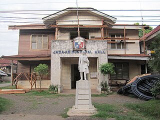
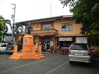
Jasaan, officially the Municipality of Jasaan, is a 2nd class municipality in the province of Misamis Oriental, Philippines. According to the 2020 census, it has a population of 57,055 people.

Jerez is a town and municipality in the Mexican state of Zacatecas. To distinguish the two, the town is officially called Jerez de García Salinas reformer, in honor of a 19th-century reformer. The town of Jerez governs 128 other communities, which comprise a rural area known for its production of fruit trees and dairy. Jerez was designated a Pueblo Mágico to promote tourism, as it is in close proximity to the state capital of Zacatecas and offers handcrafts, traditional food, and architecture."
Huixquilucan Municipality is one of the municipalities in State of Mexico, Mexico. It lies adjacent to the west side of the Federal District and is part of Greater Mexico City but independent of Mexico City itself. The name "Huixquilucan" comes from Nahuatl meaning, "place full of edible thistles".
Apozol is one of the 58 municipalities in the state of Zacatecas, Mexico.
Apulco is one of the 58 municipalities in the Mexican state of Zacatecas. It is located on the southern part of the state of Zacatecas and it is bounded by the municipality of Nochistlán de Mejía. The municipality covers a total surface area of 200 square kilometers (77 sq mi).

Nochistlán is one of the 58 municipalities in the Mexican state of Zacatecas. Founded by the Caxcanes, it was also the first site of Guadalajara in Mexico.

Atolinga is one of the 58 municipalities in the state of Zacatecas, Mexico. It is located on the southern part of the state of Zacatecas and is bordered by the municipalities of Tepechitlán and Florencia de Benito Juárez. To the east it is bordered by Tlaltenango de Sánchez Román and to the north and west by the state of Jalisco. The municipality covers a total surface area of 280 square kilometers (110 sq mi).

Calera is one of the 58 municipalities in the Mexican state of Zacatecas. It is located on the central part of the state of Zacatecas and it is bounded by the municipalities of General Enrique Estrada, Fresnillo, Villa de Cos, Pánuco, Morelos and Zacatecas. The municipality covers a total surface area of 389 square kilometers (150 sq mi). The municipality makes up for 0.5% of the area of the state of Zacatecas.

Cañitas de Felipe Pescador is one of the 58 municipalities in the state of Zacatecas, Mexico. It is located in the northern part of Zacatecas and is bounded by the municipalities of Río Grande, Villa de Cos, and Fresnillo. The municipality covers a total surface area of 482 square kilometres (186 sq mi).

Zacatecas ( ), officially the Free and Sovereign State of Zacatecas, is one of the 31 states of Mexico. It is divided into 58 municipalities and its capital city is Zacatecas.
Saín Alto is a municipality in the Mexican state of Zacatecas, located approximately 110 kilometres (68 mi) northwest of the state capital of Zacatecas City.

Morelos is a semi-urban municipality in the metropolitan area of Zacatecas City in the Mexican state of Zacatecas.


