Morelos, Zacatecas

Last updated
Morelos
Parroquia San Antonio de Padua, Morelos, Zacatecas.jpg
Parish church of Saint Anthony of Padua in Morelos
Mexico Zacatecas location map.svg
Red pog.svg
Morelos
Location in Mexico
Mexico States blank map.svg
Red pog.svg
Morelos
Morelos (Mexico)
Coordinates: 22°51′46″N102°36′30″W / 22.86278°N 102.60833°W / 22.86278; -102.60833 [1]
CountryFlag of Mexico.svg  Mexico
State Flag of Zacatecas.svg  Zacatecas
Established8 February 1869
SeatMorelos
Government
  PresidentMargarita Robles de Santiago
Area
[2]
  Total180.9 km2 (69.8 sq mi)
Elevation
[1] (of seat)
2,321 m (7,615 ft)
Highest elevation
[3] (Cerro San Gil)
2,603 m (8,540 ft)
Population
 (2020 Census) [2]
  Total13,207
  Density73/km2 (190/sq mi)
  Seat
7,515
Time zone UTC-6 (Central)
  Summer (DST) UTC-5 (Central)
Postal codes
98100–98113 [4]
Area code 492
Website Official website

Morelos is a semi-urban municipality in the metropolitan area of Zacatecas City in the Mexican state of Zacatecas. [5]

Contents

Geography

The municipality of Morelos is located at an elevation between 2,100 and 2,600 metres (6,900–8,500 ft) in central Zacatecas. It borders the municipalities of Calera to the northwest, Pánuco to the northeast, Vetagrande to the east, and Zacatecas City to the south. [6] The municipality covers an area of 180.9 square kilometres (69.8 sq mi) [2] and comprises 0.2% of the state's area. [7]

As of 2009, 71% of the land in Morelos is used for agriculture. The remainder is covered by matorral (13.7%), grassland (12.6%) and urban areas (2.4%). [6] The municipality lies in the endorheic basin of El Salado. The highest point of the municipality is Cerro San Gil in the Sierra de Zacatecas southeast of the town of Hacienda Nueva, with an elevation of 2,603 metres (8,540 ft) above sea level. [3] [6] [8]

Morelos has a temperate semi-arid climate with dry winters. [6] Average temperatures in the municipality range between 14 and 18 °C (57–64 °F), and average annual precipitation ranges between 400 and 500 millimetres (16–20 in). [6]

History

In pre-Hispanic times, the Morelos area was inhabited by the Cagihua tribe of the Zacateco people. Francisco de Ibarra passed through the area on 1 September 1554, giving it the name of Arroyo de los Chupaderos. Between 1610 and 1620, Antonio de Figueroa built and operated the first ranch in the area. [8]

After Mexican independence, Chupaderos was administered by the municipality of Vetagrande. It was declared a separate municipality on 8 February 1869 and its first municipal assembly convened in 1871. On 5 May 1894, the municipality changed its name from Chupaderos to Morelos in honour of José María Morelos. [9] The municipal seat inaugurated its first power plant in 1955 and its first potable water supply in 1966. [8]

Administration

The municipal government of Morelos comprises a president, a councillor (Spanish: síndico), and ten trustees (regidores), six elected by relative majority and four by proportional representation. [8] The current president of the municipality is Margarita Robles de Santiago. [10]

Demographics

In the 2020 Mexican Census, the municipality of Morelos recorded a population of 13,207 inhabitants living in 3614 households. [7] The 2010 Census recorded a population of 11,493 inhabitants in Morelos. [1]

INEGI lists 28 inhabited localities in the municipality, [7] of which two are classified as urban: [11]

Economy and infrastructure

General Leobardo C. Ruiz International Airport, also known as Zacatecas International Airport, is located in the municipality of Morelos. Zac airport o1.jpg
General Leobardo C. Ruiz International Airport, also known as Zacatecas International Airport, is located in the municipality of Morelos.

Economic activities in Morelos include agriculture and small businesses. Crops grown include corn, bean, barley, oats and chiles. [8] CRUCEN (Centro Regional Universitario Centro Norte), a regional centre of the agriculturally focused Chapingo Autonomous University, is located in Morelos. [12]

Federal Highways 45, 45D (the Zacatecas City bypass), and 54 all intersect in the municipality. Zacatecas International Airport is located in the northern part of the municipality.

Peñoles operated the Francisco I. Madero zinc mine in the southwestern part of the municipality from 2001 to 2020. [8] [13]

Related Research Articles

<span class="mw-page-title-main">Municipalities of Zacatecas</span>

Zacatecas is a state in North Central Mexico that is divided into 58 municipalities. According to the 2020 Mexican census, it is the state that has the 7th smallest population with 1,622,138 inhabitants and the 8th largest by land area spanning 75,275.3 square kilometres (29,064.0 sq mi).

<span class="mw-page-title-main">Calera de Víctor Rosales</span> Municipality in Zacatecas, Mexico

Calera is one of the 58 municipalities in the Mexican state of Zacatecas. It is located on the central part of the state of Zacatecas and it is bounded by the municipalities of General Enrique Estrada, Fresnillo, Villa de Cos, Pánuco, Morelos and Zacatecas. The municipality covers a total surface area of 389 square kilometers (150 sq mi). The municipality makes up for 0.5% of the area of the state of Zacatecas.

<span class="mw-page-title-main">Mazapil Municipality</span> Municipality in Zacatecas, Mexico

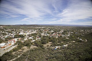
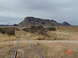
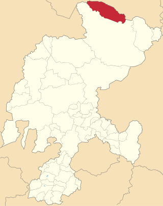
Mazapil is a municipality in the Mexican state of Zacatecas and the state's largest municipality by area. The Peñasquito mine, Mexico's largest gold mine, is located in this sparsely populated municipality.

Carácuaro is a municipality in the Mexican state of Michoacán, located 77 kilometres (48 mi) south of the state capital of Morelia.

<span class="mw-page-title-main">Seybaplaya Municipality</span> Municipality in the Mexican state of Campeche

Seybaplaya is a municipality in the Mexican state of Campeche, located 27 kilometres (17 mi) southwest of the state capital of Campeche City. Its creation was approved in 2019 and came into force on 1 January 2021.

Morelos is a municipality in the Mexican state of Michoacán, located approximately 40 kilometres (25 mi) northwest of the state capital of Morelia.

Nocupétaro is a municipality in the Mexican state of Michoacán, located approximately 75 kilometres (47 mi) south of the state capital of Morelia.

<span class="mw-page-title-main">Tzitzio</span> Municipality in Michoacán, Mexico

Tzitzio is a municipality in the Mexican state of Michoacán, located approximately 30 kilometres (19 mi) southeast of the state capital of Morelia.

<span class="mw-page-title-main">Vista Hermosa, Michoacán</span> Municipality in Michoacán, Mexico

Vista Hermosa is a municipality in the Mexican state of Michoacán, located approximately 150 kilometres (93 mi) northwest of the state capital of Morelia.

<span class="mw-page-title-main">Saín Alto Municipality</span> Municipality in Zacatecas, Mexico

Saín Alto is a municipality in the Mexican state of Zacatecas, located approximately 110 kilometres (68 mi) northwest of the state capital of Zacatecas City.

General Pánfilo Natera is a municipality in the Mexican state of Zacatecas, located approximately 50 kilometres (31 mi) east of the state capital. It is named after Pánfilo Natera, commander of the Central Division of the Constitutional Army in the Mexican Revolution, and governor of Zacatecas in 1915 and from 1940 to 1944.

<span class="mw-page-title-main">Villa González Ortega</span> Municipality in Zacatecas, Mexico

Villa González Ortega is a municipality in the Mexican state of Zacatecas, located approximately 70 kilometres (43 mi) southeast of the state capital of Zacatecas City. It is named after Jesús González Ortega.

<span class="mw-page-title-main">Noria de Ángeles</span> Municipality in Zacatecas, Mexico

Noria de Ángeles is a municipality in the Mexican state of Zacatecas, located approximately 75 kilometres (47 mi) southeast of the state capital of Zacatecas City.

<span class="mw-page-title-main">Luis Moya, Zacatecas</span> Municipality in Zacatecas, Mexico

Luis Moya is a municipality in the Mexican state of Zacatecas, located approximately 50 kilometres (31 mi) southeast of the state capital of Zacatecas City. It is named after Luis Moya (1855–1911), a colonel in the Mexican Revolution who was posthumously given the rank of brigadier general in 1939.

<span class="mw-page-title-main">Santa María de la Paz</span> Municipality in Zacatecas, Mexico

Santa María de la Paz is a municipality in the Mexican state of Zacatecas, located approximately 165 kilometres (103 mi) southwest of the state capital of Zacatecas City.

Genaro Codina is a municipality in the Mexican state of Zacatecas, located approximately 30 kilometres (19 mi) southwest of the state capital of Zacatecas City. It is named after Genaro Codina, musician and composer of the state anthem, the March of Zacatecas.

<span class="mw-page-title-main">Mezquital del Oro</span> Municipality in Zacatecas, Mexico

Mezquital del Oro is a municipality in the Mexican state of Zacatecas, located approximately 190 kilometres (120 mi) southwest of Zacatecas City, the state capital.

<span class="mw-page-title-main">Melchor Ocampo Municipality, Zacatecas</span> Municipality in Zacatecas, Mexico

Melchor Ocampo is a municipality in the Mexican state of Zacatecas, located approximately 250 kilometres (160 mi) north of Zacatecas City, the state capital. It is named after Melchor Ocampo.

El Salvador is a municipality in the Mexican state of Zacatecas, located approximately 260 kilometres (160 mi) northeast of Zacatecas City, the state capital.

<span class="mw-page-title-main">Susticacán</span> Municipality in Zacatecas, Mexico

Susticacán is a municipality in the Mexican state of Zacatecas, located approximately 55 kilometres (34 mi) west of Zacatecas City, the state capital.

References

  1. 1 2 3 "Sistema Nacional de Información Municipal" (in Spanish). SEGOB. 2010. Retrieved 12 June 2021.
  2. 1 2 3 "México en Cifras" (in Spanish). INEGI . Retrieved 11 June 2021.
  3. 1 2 "Programa Regional de Ordenamiento Territorial de Zacatecas (Centro) que abarca los municipios de Calera, Fresnillo, Genaro Codina, General Enrique Estrada, Guadalupe, Morelos, Pánuco, Trancoso, Vetagrande y Zacatecas del Estado de Zacatecas" (PDF) (in Spanish). Government of Zacatecas. 2014. p. 83. Retrieved 13 June 2021.
  4. "Consulta de Códigos Postales". Catálogo Nacional de Códigos Postales. Mexican Postal Service. 11 June 2021. Retrieved 12 June 2021.
  5. "Delimitación de las zonas metropolitanas de México 2015" [Delimitation of Mexico's Metropolitan Areas 2015] (in Spanish). CONAPO. pp. 256–257. Retrieved 12 June 2021.
  6. 1 2 3 4 5 "Morelos, Zacatecas" (PDF). Prontuario de información geográfica municipal de los Estados Unidos Mexicanos (in Spanish). INEGI. 2009. Retrieved 12 June 2021.
  7. 1 2 3 4 Panorama sociodemográfico de Zacatecas. Censo de Población y Vivienda 2020 (PDF) (in Spanish). INEGI. 2016. pp. 78–79. Retrieved 12 June 2021.
  8. 1 2 3 4 5 6 "Morelos". Enciclopedia de los Municipios y Delegaciones de México (in Spanish). INAFED . Retrieved 12 June 2021.
  9. "Morelos: Aniversario" (PDF) (in Spanish). Municipality of Morelos. 2019. Retrieved 12 June 2021.
  10. Alvarado, Silvia (8 June 2021). "Va por Zacatecas gana más municipios". Pórtico (in Spanish). Retrieved 12 June 2021.
  11. "Resumen municipal: Municipio de Morelos". Catálogo de Localidades (in Spanish). SEDESOL . Retrieved 12 June 2021.
  12. "¿Qué es el CRUCEN?" (in Spanish). Chapingo Autonomous University . Retrieved 20 June 2021.
  13. Serrano, Miriam (17 May 2020). "Cierra en Morelos la mina Madero". NTR Zacatecas (in Spanish). Retrieved 12 June 2021.

Further reading