Guadalupe, Zacatecas

Last updated
Guadalupe
Panoramica de Guadalupe.JPG
GUADALUPE, ZACATECAS (19).JPG
Los Conos de Tlacoaleche.jpg
GuadalupeMuseumZacatecas003.jpg
Fachada presidencia Guadalupe Zacatecas.jpg
Top: Panoramic view of Guadalupe; middle: Convent of Our Lady of Guadalupe (left) and Cones of Santa Monica (right); Museum of Guadalupe (left) and Seat of Municipal Government (right).
Bandera Guadalupe, Zacatecas.jpg
Escudo de Guadalupe, Zacatecas.svg
Motto(s): 
Historia, Trabajo, Progreso
(History, Labor, Progress)
Mexico Zacatecas location map.svg
Red pog.svg
Guadalupe
Location in Mexico
Mexico States blank map.svg
Red pog.svg
Guadalupe
Guadalupe (Mexico)
Coordinates: 22°45′10″N102°30′28″W / 22.75278°N 102.50778°W / 22.75278; -102.50778
CountryFlag of Mexico.svg  Mexico
State Zacatecas
Municipality Guadalupe
Government
   Municipal President José Saldívar Alcalde Morena logo (Mexico).svg
Elevation
2,334 m (7,657 ft)
Population
 (2020)
  Total211,740 [1]
Time zone UTC-6 (CST)
  Summer (DST) UTC-5 (CDT)
Area code 492
Climate BSk
Website https://gobiernodeguadalupe.gob.mx/
Official nameCamino Real de Tierra Adentro
Criteria Cultural: ii, iv
Reference 1351-030
Inscription2010 (34th Session)

Guadalupe is a town in the state of Zacatecas, Mexico. It is located in the central region of the state and is the head of the Municipality of Guadalupe. With a population of 170,029 inhabitants, it is the most populated city in the state and with the city of Zacatecas and surrounding towns it forms a metropolitan area. On August 1, 2010, the Camino Real de Tierra Adentro was inscribed by UNESCO on the World Heritage List, being the former Apostolic College of Propaganda Fide of Our Lady of Guadalupe, one of the sites on the cultural itinerary that reached this title, for its architectural richness and contribution to the evangelization of the north of New Spain. On June 30, 2015, the Legislative Branch of the State of Zacatecas approved that the city of Guadalupe Zacatecas be declared a Historical City, a title that came into effect on Thursday, September 3 of that same year after its promulgation in decree number 400 published in the Official Newspaper of the State of Zacatecas. On October 11, 2018 at the Fifth National Fair of Pueblos Mágicos held in the city of Morelia, Michoacán, Guadalupe received incorporation into the Pueblos Mágicos program, being the sixth to have this registration in the state of Zacatecas.

Contents

History

Prehispanic

Until before the arrival of the Spanish (1546), the city's territories were hunting grounds as well as fruit gathering by small semi-nomadic groups such as the Zacatecos and the Guachichiles.

Viceroyalty of New Spain

The territory currently occupied by the city of Guadalupe began to be populated after the discovery of the Zacatecas Mines in 1546, with the establishment of haciendas, ranches and orchards that supplied livestock and provisions to the Very Noble and Loyal City of Our Lady of the Zacatecas. Since there is no formal act of founding a town, the year of founding is taken as a reference to the most remote antecedent of land ownership. According to the latest research, it is the year 1555, when Pedro de Ahumada Sámano obtained a land grant for small livestock three quarters of a league from the mines of Zacatecas, on the way to Mexico City, a place that would be known as San Nicolás de los Campos, located where the Arboledas, Campo Bravo and El Carmen neighborhoods are currently located. However, there are versions that date the origin to the granting by the Royal Court of Guadalajara of a land grant to Gonzalo de Cabañas in 1575 of the territory occupied by the Bernárdez hacienda; as well as the issuance of a grant in July 1578 to the Spaniard Diego Chávez de Montoro, from the site where the historic center of the city of Guadalupe is located.

Jerónima de Castilla, widow of Diego de Melgar, gave up a chapel dedicated to Our Lady of Carmel, located outside the city of Zacatecas, which was in ruins, in addition to the land necessary for the construction of a new sanctuary dedicated to Our Lady of Guadalupe, similar to the one built in Mexico City. Ecclesiastical license was granted for this purpose on January 16, 1677.

The Franciscans founded a collection hospice in the same place where the chapel was located, bearing the name of Our Lady of Guadalupe. Later, after obtaining the Royal Decree in January 1704 from Philip V of Spain, on January 12, 1707, the Apostolic College of Propaganda Fide of Our Lady of Guadalupe was founded by the Franciscans Antonio Margil de Jesús, José de Castro, José Guerra, Alonso González, Pedro Franco, José de San Francisco, among others; With the missionary work of this College, Guadalupe acquired great fame and reputation, since it was a Fide Propaganda Center for the promotion of the Christian faith, for a large portion of the northern area of the Viceroyalty of New Spain and a large part of the states from the south of what is now the United States.

19th Century

During the Independence movement, due to its geographical location, the municipality of Guadalupe was the scene of various relevant events. From January 27 to February 5, 1811, after his defeat in the Battle of Puente de Calderón as he moved towards Northern Mexico, Miguel Hidalgo y Costilla stayed in Guadalupe for 10 days, this fact gave rise to the musical composition "Las Mañanas de Hidalgo", which is considered one of the oldest antecedents of the corrido in Mexico.

At the local level, the figure of José María Rodríguez stands out, who together with the priest Antonio Torres and Víctor Rosales, conspired to surrender the capital to the insurgency. Rodríguez was taken prisoner and sentenced to death, being shot and beheaded on October 3, 1814, placing his head on a stake to serve as a warning to others.

On November 13, 1821, Guadalupe, which until then was part of the territory of the city of Zacatecas, was established as a City Council under the regulations of the Constitution of Cádiz. However, in 1825 it was repealed to the rank of congregational board, not being until 1829 when it was again established as a City Council in accordance with the provisions of the Political Constitution of the State of Zacatecas.

In 1845 the Departmental Assembly of Zacatecas granted Guadalupe the title of Villa de Guadalupe de Rodríguez.

President Benito Juárez, established his itinerant government in Guadalupe on February 16, 1867, before his withdrawal to the state of San Luis Potosí.

20th Century

On June 23, during the famous Capture of Zacatecas, the road that connects Guadalupe with the city of Zacatecas was the escape point for the federalist army, and a considerable number of elements were shot down in the attempt.

During the first days of October 1914, Guadalupe was the scene of the meeting between Zapatista and Villista troops, as a preamble to the Convention of Aguascalientes.

With the issuance of the Free Municipality Law promulgated by Venustiano Carranza, the Political Headquarters of the Zacatecas Party made up of the municipalities of Zacatecas, Guadalupe, Chupaderos, Calera and Panúco is abolished, obtaining these demarcations administrative autonomy and without intermediate figures between the town councils and the State Executive. On August 1, 1915, the Civil Administration Board was established in Guadalupe, thereby establishing itself as a free municipality, a status ratified with the Political Constitution of the Free and Sovereign State of Zacatecas of 1918, a category in force to date.

Related Research Articles

<span class="mw-page-title-main">Aguascalientes (city)</span> City in the Mexican state of Aguascalientes

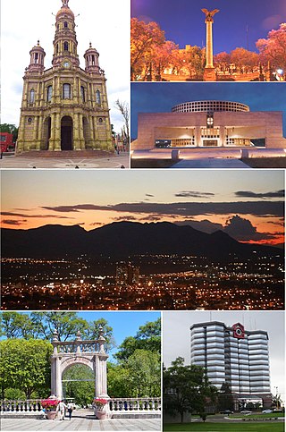
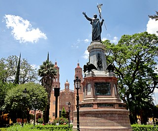
Aguascalientes is the capital of the Mexican state of the same name and its most populous city, as well as the head of the Aguascalientes Municipality; with a population of 934,424 inhabitants in 2012 and 1,225,432 in the metro area. The metropolitan area also includes the municipalities of Jesús María and San Francisco de los Romo. It is located in North-Central Mexico, which roughly corresponds to the Bajío region (Lowlands) within the central Mexican plateau. The city stands on a valley of steppe climate at 1880 meters above sea level, at 21°51′N102°18′W.

<span class="mw-page-title-main">Dolores Hidalgo</span> City and Municipality in Guanajuato, Mexico

Dolores Hidalgo is the name of a city and the surrounding municipality in the north-central part of the Mexican state of Guanajuato.

Guadalupe or Guadeloupe may refer to:

<span class="mw-page-title-main">Aguascalientes</span> State of Mexico

Aguascalientes, officially the Free and Sovereign State of Aguascalientes, is one of the 32 states which comprise the Federal Entities of Mexico. At 22°N and with an average altitude of 1,950 m (6,400 ft) above sea level it is predominantly of semi-arid climate. The state is located in west-central Mexico and is located in the northern part of the Bajío region, which is in the north-central part of the country, bordered by Zacatecas to the north, east and west, and by Jalisco to the south.

<span class="mw-page-title-main">Huamantla</span> Municipal seat in Tlaxcala, Mexico

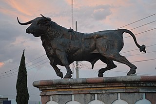
Huamantla is a small city in the municipality of the same name in the eastern half of the Mexican state of Tlaxcala. The area has a long indigenous history, but the city itself was not founded until the early colonial period, in the 1530s. It is mostly agricultural but it is best known for its annual homage to an image of the Virgin Mary called Our Lady of Charity. This includes a month of festivities, the best known of which are the “night no one sleeps” when residents create six km of “carpets” on the streets made from colored sawdust, flowers and other materials. The other is the “Huamantlada” a running of the bulls similar to that in Pamplona.

Parras de la Fuente is a city located in the southern part of the Mexican state of Coahuila. The city serves as the municipal seat of the surrounding Parras Municipality, which has an area of 9,271.7 km2 (3,579.8 sq mi).

<span class="mw-page-title-main">Totatiche</span> Place in Jalisco, Mexico

The municipality and town of Totatiche is located in the northern extreme of the state of Jalisco, Mexico between 21°48’30” and 22°06’00” latitude north and 103°20’00” and 103°34’00” longitude east at a height of 1,751 meters (5,745 ft) above sea level. The municipality is bordered on the north and southeast by the state of Zacatecas. On the northeast, it shares its border with the municipality of Colotlán and on the west it is bordered by the municipalities of Villa Guerrero and Chimaltitán.

<span class="mw-page-title-main">San Juan del Río</span> City in Querétaro, Mexico

San Juan del Río is a city and administration of the surrounding San Juan del Río Municipality in the central Mexican state of Querétaro. The population in for the municipality is 268,408 as of 2015.

<span class="mw-page-title-main">Valparaíso, Zacatecas</span> City in Zacatecas, Mexico

Valparaíso is a city in the north central Mexican state of Zacatecas.

<span class="mw-page-title-main">Zamora, Michoacán</span> Place in Michoacán, Mexico

Zamora de Hidalgo(Spanish pronunciation: [saˈmoɾa de i'dalɢo]) is a city in the Mexican state of Michoacán. The 2010 census population was 141,627. making it the third largest city in the state. The city is the municipal seat of Zamora Municipality, which has an area of 330.97 km² and includes many other smaller communities, the largest of which is Ario de Rayón. The municipality's population is around 186,102, which makes it the second most populous urban area in the state.

<span class="mw-page-title-main">Camino Real de Tierra Adentro</span> Northernmost of Mexico Citys four "royal roads"

The Camino Real de Tierra Adentro, also known as the Silver Route, was a Spanish 2,560-kilometre-long (1,590 mi) road between Mexico City and San Juan Pueblo, New Mexico, that was used from 1598 to 1882. It was the northernmost of the four major "royal roads" that linked Mexico City to its major tributaries during and after the Spanish colonial era.

<span class="mw-page-title-main">Jerez de García Salinas</span> City in Zacatecas, Mexico

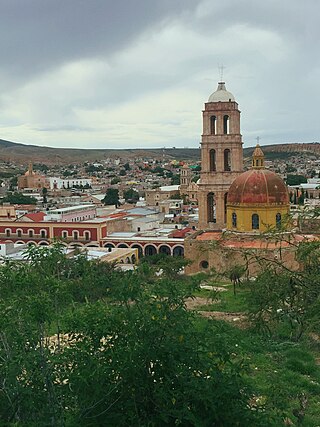
Jerez is a town and municipality in the Mexican state of Zacatecas. To distinguish the two, the town is officially called Jerez de García Salinas reformer, in honor of a 19th-century reformer. The town of Jerez governs 128 other communities, which comprise a rural area known for its production of fruit trees and dairy. Jerez was designated a Pueblo Mágico to promote tourism, as it is in close proximity to the state capital of Zacatecas and offers handcrafts, traditional food, and architecture."

<span class="mw-page-title-main">Sombrerete, Zacatecas</span> City & Municipality in Zacatecas, Mexico

Sombrerete is a town and municipality located in the northwest of the Mexican state of Zacatecas, bordering the state of Durango.

<span class="mw-page-title-main">Teúl de González Ortega Municipality</span> Municipality in Zacatecas, Mexico

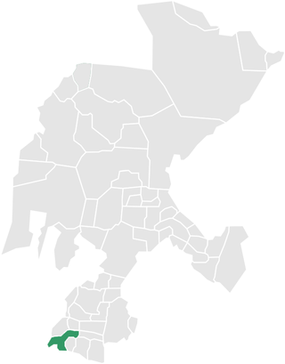
Teúl de González Ortega Municipality is a town and municipality located in the south of the Mexican state of Zacatecas, between the state capital of Zacatecas and the city of Guadalajara. Unlike most of the rest of the state, its economy has been based on agriculture and livestock, rather than mining, and it is noted for its production of agave and mezcal. The town has been named a Pueblo Mágico to promote a tourism industry.

Villa García Municipality is one of the 58 municipalities of the state of Zacatecas, Mexico. It is located 140 kilometers from the city of Zacatecas.

<span class="mw-page-title-main">Acanceh Municipality</span> Municipality in the Mexican state of Yucatán

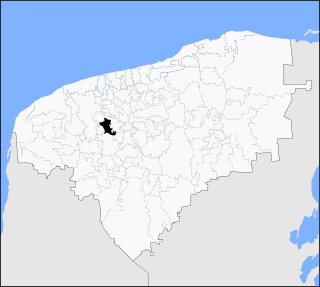
Acanceh Municipality is one of the 106 municipalities in the Mexican state of Yucatán containing (153.29 km2) of land and located roughly 32 km southeast of the city of Mérida.

<span class="mw-page-title-main">Baca Municipality</span> Municipality in the Mexican state of Yucatán

Baca Municipality is one of the 106 municipalities in the Mexican state of Yucatán containing (118.78 km2) of land and located roughly 32 km east of the city of Mérida.

<span class="mw-page-title-main">Chicxulub Pueblo Municipality</span> Municipality in the Mexican state of Yucatán

Chicxulub Pueblo Municipality is one of the 106 municipalities in the Mexican state of Yucatán containing (196.72 km2) of land and located roughly 25 km north of the city of Mérida. The area was considered the epicenter of the Chicxulub crater.

<span class="mw-page-title-main">History of Monterrey</span> Aspect of history

The history of the Mexican city of Monterrey is closely linked with the history of the state of Nuevo León. When the New Kingdom of León was founded, it included Monterrey, Monclova, Saltillo and Cerralvo. The founding families formed a group of about thirty people in each locality. Gradually, Nuevo León was populated with families of nomadic herders of Portuguese origin who fought and displaced the native indigenous groups in the region. The city was a step away from the border with the United States and it began to be a strategic location for industry and trade between the two countries. Originally isolated by the Sierra Madre and far from the center of New Spain and independent Mexico, in the late 19th century and throughout the twentieth century various demographic, social, political, and economic issues began to unfold.

Tacámbaro is a municipality located in the central region of the Mexican state of Michoacán. Its largest city and municipal seat is Heroica Tacámbaro de Codallos.

References

  1. Instituto Nacional de Estadística y Geografía (2020). "Resultados Censo de Población y Vivienda 2020 (ITER)".