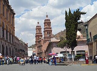
Zacatecas is the principal city within the municipality in Mexico of the same name, and the capital and the largest city of the state of Zacatecas. Located in north-central Mexico, the city had its start as a Spanish mining camp in the mid-16th century. Native Americans had already known about the area's rich deposits of silver and other minerals. Due to the wealth that the mines provided, Zacatecas quickly became one of the most important mining cities in New Spain. The area saw battles during the turbulent 19th century, but the next major event was the Battle of Zacatecas during the Mexican Revolution when Francisco Villa captured the town, an event still celebrated every anniversary. Today, the colonial part of the city is a World Heritage Site, due to the Baroque and other structures built during its mining days. Mining still remains an important industry. The name Zacatecas is derived from the Zacateco people and has its roots in Nahuatl. The name means "people of the grasslands".

Oaxaca is a state in Southwest Mexico that is divided into 570 municipalities, more than any other state in Mexico. According to Article 113 of the state's constitution, the municipalities are grouped into 30 judicial and tax districts to facilitate the distribution of the state's revenues. It is the only state in Mexico with this particular judicial and tax district organization. Oaxaca is the tenth most populated state with 4,132,148 inhabitants as of the 2020 Mexican census and the fifth largest by land area spanning 93,757.6 square kilometres (36,200.0 sq mi).

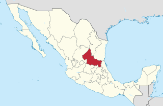
Zacatecas is a state in North Central Mexico that is divided into 58 municipalities. According to the 2020 Mexican census, it is the state that has the 7th smallest population with 1,622,138 inhabitants and the 8th largest by land area spanning 75,275.3 square kilometres (29,064.0 sq mi).
San Luis Potosí is a state in North Central Mexico that is divided into 58 municipalities. According to the 2020 Mexican census, it is the 19th most populated of Mexico's 31 states, with 2,822,255 inhabitants and the 15th largest by land area spanning 61,138.0 square kilometres (23,605.5 sq mi). The largest municipality by population is the city of San Luis Potosí, with 911,908 residents, while the smallest is Armadillo with 4,013 residents. The largest municipality by land area is Santo Domingo which spans 4,322.60 km2 (1,669.0 sq mi), and the smallest is Huehuetlán with 71.50 km2 (27.61 sq mi). The newest municipalities are El Naranjo, created out of Ciudad del Maíz, and Matlapa, carved from Tamazunchale, both established in 1994.

Juan Aldama was a Mexican revolutionary rebel soldier during the Mexican War of Independence in 1810.
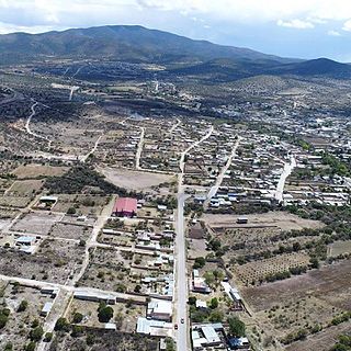
The Municipality of Juan Aldama was named in honor of the insurgent Juan Aldama, who participated alongside Miguel Hidalgo in the Mexican War of Independence. It is also the name of the biggest community in the municipality.

The Camino Real de Tierra Adentro, also known as the Silver Route, was a Spanish 2,560-kilometre-long (1,590 mi) road between Mexico City and San Juan Pueblo, New Mexico, that was used from 1598 to 1882. It was the northernmost of the four major "royal roads" that linked Mexico City to its major tributaries during and after the Spanish colonial era.

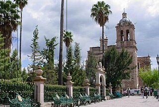
Jerez is a town and municipality in the Mexican state of Zacatecas. To distinguish the two, the town is officially called Jerez de García Salinas reformer, in honor of a 19th-century reformer. The town of Jerez governs 128 other communities, which comprise a rural area known for its production of fruit trees and dairy. Jerez was designated a Pueblo Mágico to promote tourism, as it is in close proximity to the state capital of Zacatecas and offers handcrafts, traditional food, and architecture."
Sombrerete is a town and municipality located in the northwest of the Mexican state of Zacatecas, bordering the state of Durango.

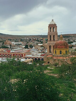
Guadalupe is a town in the state of Zacatecas, Mexico. It is located in the central region of the state and is the head of the Municipality of Guadalupe. With a population of 170,029 inhabitants, it is the most populated city in the state and with the city of Zacatecas and surrounding towns it forms a metropolitan area. On August 1, 2010, the Camino Real de Tierra Adentro was inscribed by UNESCO on the World Heritage List, being the former Apostolic College of Propaganda Fide of Our Lady of Guadalupe, one of the sites on the cultural itinerary that reached this title, for its architectural richness and contribution to the evangelization of the north of New Spain. On June 30, 2015, the Legislative Branch of the State of Zacatecas approved that the city of Guadalupe Zacatecas be declared a Historical City, a title that came into effect on Thursday, September 3 of that same year after its promulgation in decree number 400 published in the Official Newspaper of the State of Zacatecas. On October 11, 2018 at the Fifth National Fair of Pueblos Mágicos held in the city of Morelia, Michoacán, Guadalupe received incorporation into the Pueblos Mágicos program, being the sixth to have this registration in the state of Zacatecas.

Jilotepec de Molina Enríquez, known as Jilotepec de Abasolo until 1986, and commonly known as Jilotepec, is a city located in the northwest zone of the State of Mexico in Mexico. The name comes from Náhuatl, meaning "hill of corncobs". It is the municipal seat and largest city of the municipality of Jilotepec. It is located in hilly and forested terrain about an hour's drive from Mexico City and the state capital of Toluca, 40 minutes from San Juan del Río, 30 minutes from Tula and 20 minutes from Tepeji. The Mexico City–Querétaro highway and the new Transoceanic Freeways that unite the coasts of Mexico from Veracruz to Michoacán converge within its territory.
Villanueva is a city in the Mexican state of Zacatecas. It is the administrative seat of the municipality of Villanueva.
Federal Highway 71 (Fed. 71) is a free (libre) part of the federal highways corridors of Mexico. Fed. 71 exists in two separate segments; the first runs from Fed. 45 at Luis Moya, Zacatecas in the north to Providencia, Aguascalientes in the south. The second segment runs from San Felipe, Aguascalientes in the north to Villa Hidalgo, Jalisco in the south. The highway continues on from Villa Hidalgo to Teocaltiche as Jal 211.

Huejúcar is a town and municipality, in Jalisco in central-western Mexico. The municipality covers an area of 309.2 km2.

Francisco García Salinas, known as "Tata Pachito" was born in Jerez, Zacatecas, Mexico. He was a Mexican politician, Deputy and Senator, noted for his participation in the Second Mexican Constituent Congress. He was Minister of Finance (1827–1828) and Governor of Zacatecas, where he promoted important reforms.
Villa Insurgentes, better known as is a town located in the municipality of Sombrerete. There are 2,837 inhabitants; it is 2150 meters in elevation. The area around Villa Insurgentes has a small population, with 16 people per square kilometer. The nearest city is Vicente Guerrero 14.5 km west.
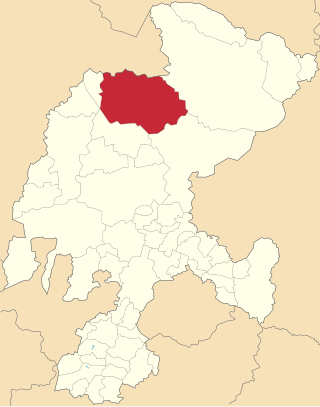
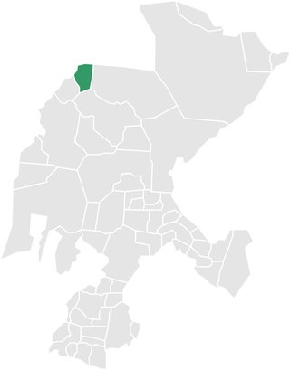
General Francisco R. Murguía is a municipality in the Mexican state of Zacatecas, located approximately 140 kilometres (87 mi) north of the state capital of Zacatecas City.

Noria de Ángeles is a municipality in the Mexican state of Zacatecas, located approximately 75 kilometres (47 mi) southeast of the state capital of Zacatecas City.


