El Salvador | |
---|---|
Coordinates: 24°31′10″N100°52′03″W / 24.51944°N 100.86750°W [1] | |
Country | ![]() |
State | ![]() |
Established | 14 November 1964 |
Seat | El Salvador |
Government | |
• Municipal president | Miguel Coronado Gómez |
Area | |
• Total | 623.9 km2 (240.9 sq mi) |
Elevation [1] (of seat) | 1,721 m (5,646 ft) |
Population (2020 Census) [2] | |
• Total | 2,509 |
• Density | 4.0/km2 (10/sq mi) |
• Seat | 982 |
Time zone | UTC-6 (Central) |
• Summer (DST) | UTC-5 (Central) |
Postal code | 98290 [3] |
Area code | 844 |
El Salvador is a municipality in the Mexican state of Zacatecas, located approximately 260 kilometres (160 mi) northeast of Zacatecas City, the state capital.
The municipality of El Salvador lies at an elevation between 1,800 and 2,900 metres (5,900–9,500 ft) in the foothills of the Sierra Madre Oriental in northeastern Zacatecas. It borders the municipalities of Concepción del Oro in Zacatecas to the west, Saltillo in Coahuila to the north, Galeana in Nuevo León to the northeast, and Vanegas in San Luis Potosí to the southeast. [4] The municipality covers an area of 623.9 square kilometres (240.9 sq mi) and comprises 0.8% of the state's area. [2]
The land cover in El Salvador is mostly Meseta Central matorral (81%) with small tracts of forest (11%) and grassland (8%) also present. The municipality is situated in the Matehuala sub-basin of the Llanos el Salado. [4]
El Salvador's climate ranges from semiarid to arid desert. Average temperatures in the municipality range between 12 and 20 °C (54–68 °F), and average annual precipitation ranges between 300 and 600 millimetres (12–24 in). [4]
Climate data for El Salvador weather station at 24°31′15″N100°52′18″W / 24.52083°N 100.87167°W , 1726 m above sea level (1981–2010 averages, 1951–2010 extremes) | |||||||||||||
---|---|---|---|---|---|---|---|---|---|---|---|---|---|
Month | Jan | Feb | Mar | Apr | May | Jun | Jul | Aug | Sep | Oct | Nov | Dec | Year |
Record high °C (°F) | 38.0 (100.4) | 36.0 (96.8) | 40.0 (104.0) | 44.0 (111.2) | 40.0 (104.0) | 45.0 (113.0) | 43.0 (109.4) | 45.0 (113.0) | 43.0 (109.4) | 45.0 (113.0) | 40.0 (104.0) | 36.0 (96.8) | 45.0 (113.0) |
Average high °C (°F) | 21.0 (69.8) | 23.4 (74.1) | 26.1 (79.0) | 29.1 (84.4) | 30.7 (87.3) | 29.4 (84.9) | 29.8 (85.6) | 29.6 (85.3) | 28.5 (83.3) | 27.4 (81.3) | 24.3 (75.7) | 21.8 (71.2) | 26.8 (80.2) |
Daily mean °C (°F) | 11.4 (52.5) | 13.3 (55.9) | 15.6 (60.1) | 18.7 (65.7) | 20.7 (69.3) | 20.8 (69.4) | 21.2 (70.2) | 20.9 (69.6) | 19.9 (67.8) | 18.0 (64.4) | 14.2 (57.6) | 11.6 (52.9) | 17.2 (63.0) |
Average low °C (°F) | 1.7 (35.1) | 3.3 (37.9) | 5.1 (41.2) | 8.2 (46.8) | 10.8 (51.4) | 12.2 (54.0) | 12.5 (54.5) | 12.1 (53.8) | 11.4 (52.5) | 8.5 (47.3) | 4.0 (39.2) | 1.5 (34.7) | 7.6 (45.7) |
Record low °C (°F) | −14.0 (6.8) | −9.0 (15.8) | −9.0 (15.8) | −5.0 (23.0) | 3.0 (37.4) | 4.0 (39.2) | 6.0 (42.8) | 5.0 (41.0) | −8.0 (17.6) | −5.0 (23.0) | −8.0 (17.6) | −13.0 (8.6) | −14.0 (6.8) |
Average precipitation mm (inches) | 11.5 (0.45) | 12.6 (0.50) | 7.1 (0.28) | 24.0 (0.94) | 44.8 (1.76) | 66.3 (2.61) | 66.6 (2.62) | 59.5 (2.34) | 66.7 (2.63) | 28.7 (1.13) | 11.1 (0.44) | 12.5 (0.49) | 411.4 (16.20) |
Average rainy days (≥ 1 mm) | 1.8 | 1.7 | 1.5 | 2.9 | 6.0 | 7.6 | 7.6 | 8.2 | 7.0 | 3.3 | 1.4 | 1.8 | 50.8 |
Source: Servicio Meteorológico Nacional [5] [6] |
Cave paintings in the municipality demonstrate past occupation of the area by Irritila tribes. [7] Colonial settlement of the area dates to the 18th century, when it was part of the Hacienda El Salado. Based in the neighbouring state of San Luis Potosí, this was one of the largest haciendas in Mexico, and was owned by Juan Bustamante, a former governor of that state. [8] Matías Ramos Santos , who was born in El Salvador in 1891, served as Governor of Zacatecas from 1932 to 1936, [9] and as Secretary of National Defence from 1952 to 1958. [10]
The congregacíon of El Salvador was established in the municipality of Concepción del Oro on 14 November 1964. It became an independent municipality a week later on 21 November 1964. [11]
The municipal government of El Salvador comprises a president, a councillor (Spanish: síndico), [7] and seven trustees (regidores), four elected by relative majority and three by proportional representation. [12] The current president of the municipality is Miguel Coronado Gómez. [13]
In the 2020 Mexican Census, the municipality of El Salvador recorded a population of 2509 inhabitants living in 733 households. [2] The 2010 Census recorded a population of 2710 inhabitants in El Salvador. [14]
There are 24 inhabited localities in the municipality, [2] of which only the municipal seat, also called El Salvador, is classified as urban. [14] It recorded a population of 982 inhabitants in the 2020 Census. [2]
In the 2015 Intercensal Survey, 53% of El Salvador's workforce was employed in the primary sector, 16% in the secondary sector, 6% in commerce, and 24% in services. [15] Agricultural activities in the municipality include cattle and goat farming. [16]
The Kansas City Southern de México railway runs north to south through the municipality.
Granados is a municipality in the Mexican state of Sonora, located approximately 180 kilometres (110 mi) northeast of Hermosillo, the state capital. It is named after José Joaquín Granados y Gálvez, the second bishop of Sonora from 1788 to 1794.
Mazapil is a municipality in the Mexican state of Zacatecas and the state's largest municipality by area. The Peñasquito mine, Mexico's largest gold mine, is located in this sparsely populated municipality.
Jilotepec is a municipality in the Mexican state of Veracruz, located 11 kilometres (6.8 mi) north-northwest of the state capital Xalapa.
Citlaltépetl is a municipality in the Mexican state of Veracruz, located 223 kilometres (139 mi) northwest of the state capital of Xalapa and 99 kilometres (62 mi) south of the city of Tampico, Tamaulipas.
Contepec is a municipality in the Mexican state of Michoacán, located 110 kilometres (68 mi) east of the state capital of Morelia.
Jiménez is a municipality in the Mexican state of Michoacán, located approximately 65 kilometres (40 mi) west of the state capital of Morelia.
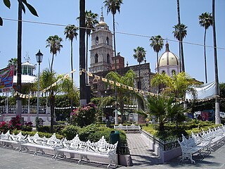
Senguio is a municipality in the Mexican state of Michoacán, located approximately 90 kilometres (56 mi) east of the state capital of Morelia.
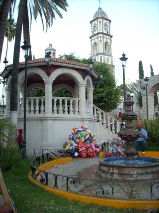
Tzitzio is a municipality in the Mexican state of Michoacán, located approximately 30 kilometres (19 mi) southeast of the state capital of Morelia.
Tanhuato is a municipality in the Mexican state of Michoacán, located approximately 135 kilometres (84 mi) northwest of the state capital of Morelia.
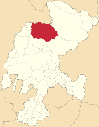
General Francisco R. Murguía is a municipality in the Mexican state of Zacatecas, located approximately 140 kilometres (87 mi) north of the state capital of Zacatecas City.
Saín Alto is a municipality in the Mexican state of Zacatecas, located approximately 110 kilometres (68 mi) northwest of the state capital of Zacatecas City.
Morelos is a semi-urban municipality in the metropolitan area of Zacatecas City in the Mexican state of Zacatecas.
General Pánfilo Natera is a municipality in the Mexican state of Zacatecas, located approximately 50 kilometres (31 mi) east of the state capital. It is named after Pánfilo Natera, commander of the Central Division of the Constitutional Army in the Mexican Revolution, and governor of Zacatecas in 1915 and from 1940 to 1944.
Villa González Ortega is a municipality in the Mexican state of Zacatecas, located approximately 70 kilometres (43 mi) southeast of the state capital of Zacatecas City. It is named after Jesús González Ortega.
Noria de Ángeles is a municipality in the Mexican state of Zacatecas, located approximately 75 kilometres (47 mi) southeast of the state capital of Zacatecas City.
Luis Moya is a municipality in the Mexican state of Zacatecas, located approximately 50 kilometres (31 mi) southeast of the state capital of Zacatecas City. It is named after Luis Moya (1855–1911), a colonel in the Mexican Revolution who was posthumously given the rank of brigadier general in 1939.
Genaro Codina is a municipality in the Mexican state of Zacatecas, located approximately 30 kilometres (19 mi) southwest of the state capital of Zacatecas City. It is named after Genaro Codina, musician and composer of the state anthem, the March of Zacatecas.
Mezquital del Oro is a municipality in the Mexican state of Zacatecas, located approximately 190 kilometres (120 mi) southwest of Zacatecas City, the state capital.
Trinidad García de la Cadena is a municipality in the Mexican state of Zacatecas, located approximately 200 kilometres (120 mi) southwest of Zacatecas City, the state capital. It is named after General Trinidad García de la Cadena, governor of Zacatecas from 1869 to 1870 and from 1876 to 1880.
Susticacán is a municipality in the Mexican state of Zacatecas, located approximately 55 kilometres (34 mi) west of Zacatecas City, the state capital.
{{cite book}}
: |work=
ignored (help){{cite book}}
: |work=
ignored (help)