Saín Alto

Last updated
Saín Alto
Mexico Zacatecas location map.svg
Red pog.svg
Saín Alto
Location of Saín Alto
Mexico States blank map.svg
Red pog.svg
Saín Alto
Saín Alto (Mexico)
Coordinates: 23°34′52″N103°14′53″W / 23.58111°N 103.24806°W / 23.58111; -103.24806
CountryFlag of Mexico.svg  Mexico
State Zacatecas
Municipality Saín Alto
Founded1555
Elevation
2,045 m (6,709 ft)
Population
 (2020)
  Total5,295
Area code 498

Sain Alto is a locality in the Mexican state of Zacatecas. It serves as the municipal seat of the eponymous Sain Alto Municipality.

Contents

Climate

Saín Alto has a cold steppe climate. [1] The average annual temperature in the town is 21 °C (70 °F). The warmest month is May, with an average temperature of 29 °C (84 °F), and the coldest is January, at 14 °C (57 °F). [2] Average annual rainfall is 559 mm (22.0 in). The wettest month is September, with an average of 146 mm (5.7 in) of precipitation, and the driest is March, at 1 mm (0.039 in). [3]

History

Saín Alto derives from Zaín  [ es ] or Çayn, [4] a group of Zacateco people who established the settlement of Saín Alto sometime around 1535–1540. [5] These people were led by a cacique named Saín Alonso. The town's full name was originally "San Sebastián con el renombre de Saín", but it eventually became known as San Sebastián de Saín Alto and later simply Saín Alto. The earliest Spanish conquistadors to come into contact with the people of Zaín were Ginés Vázquez de Mercado  [ es ] in 1552 and 1553, and Francisco de Ibarra in September 1554. [5]

With the first Zacatecas state constitution of 1825, Saín Alto became the seat of its own municipality. The latter became a free municipality on 19 August 1916. [5] [6] Mercury mining began in the municipality in 1934, and accounted for 12% of Mexico's mercury production in the years of 1939 and 1940. [5]

Demographics

In the 2020 Mexican Census, Saín Alto recorded a population of 5,295 inhabitants. [7]

Related Research Articles

<span class="mw-page-title-main">Coatepec, Veracruz</span> City and municipality in Veracruz, Mexico

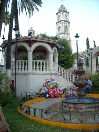
The municipality of Coatepec is located in the central region of the Mexican state of Veracruz. Its north latitude is 19° 27′, west longitude is 96° 58′, altitude of 1,200.00 m (3,937.01 ft), and surface of 202.4 km2 (78.1 sq mi). It represents the 0.338% of the current state. The municipal seat and largest community of the municipality is also called Coatepec. The Mexican census of 2020 reported a population of 55,720 in the city, while the municipality had 93,911 inhabitants. The municipality also includes many smaller communities within its boundaries. The largest of these are Tuzamapan,, Pacho Viejo, and Mahuixtlán.

<span class="mw-page-title-main">Aguascalientes</span> State of Mexico

Aguascalientes, officially the Free and Sovereign State of Aguascalientes, is one of the 32 states which comprise the Federal Entities of Mexico. At 22°N and with an average altitude of 1,950 m (6,400 ft) above sea level it is predominantly of semi-arid climate. The state is located in the northern part of the Bajío region, which is in the north-central part of the country, bordered by Zacatecas to the north, east and west, and by Jalisco to the south.

<span class="mw-page-title-main">Sombrerete, Zacatecas</span> City and municipality in Zacatecas, Mexico

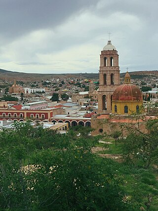
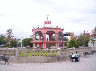
Sombrerete is a town and municipality located in the northwest of the Mexican state of Zacatecas, bordering the state of Durango.

<span class="mw-page-title-main">Zacatecas</span> State of Mexico

Zacatecas ( ), officially the Free and Sovereign State of Zacatecas, is one of the 31 states of Mexico. It is divided into 58 municipalities and its capital city is Zacatecas.

<span class="mw-page-title-main">Río Grande Municipality, Zacatecas</span> Municipality in Zacatecas, Mexico

Río Grande is a municipality in the Mexican state of Zacatecas.

<span class="mw-page-title-main">General Francisco R. Murguía Municipality</span> Municipality in Zacatecas, Mexico

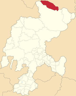
General Francisco R. Murguía is a municipality in the Mexican state of Zacatecas, located approximately 140 kilometres (87 mi) north of the state capital of Zacatecas City. Its municipal seat is located in Nieves.

<span class="mw-page-title-main">Miguel Auza Municipality</span> Municipality in Zacatecas, Mexico

Miguel Auza is a municipality in the Mexican state of Zacatecas, located approximately 190 kilometres (120 mi) northwest of the state capital of Zacatecas City.

<span class="mw-page-title-main">Saín Alto Municipality</span> Municipality in Zacatecas, Mexico

Sain Alto is a municipality in the Mexican state of Zacatecas, located approximately 110 kilometres (68 mi) northwest of the state capital of Zacatecas City.

<span class="mw-page-title-main">Morelos, Zacatecas</span> Municipality in Zacatecas, Mexico

Morelos is a semi-urban municipality in the Zacatecas metropolitan area in the Mexican state of Zacatecas.

General Pánfilo Natera is a municipality in the Mexican state of Zacatecas, located approximately 50 kilometres (31 mi) east of the state capital. It is named after Pánfilo Natera, commander of the Central Division of the Constitutional Army in the Mexican Revolution, and governor of Zacatecas in 1915 and from 1940 to 1944.

<span class="mw-page-title-main">Villa González Ortega</span> Municipality in Zacatecas, Mexico

Villa González Ortega is a municipality in the Mexican state of Zacatecas, located approximately 70 kilometres (43 mi) southeast of the state capital of Zacatecas City. It is named after Jesús González Ortega.

<span class="mw-page-title-main">Luis Moya, Zacatecas</span> Municipality in Zacatecas, Mexico

Luis Moya is a municipality in the Mexican state of Zacatecas, located approximately 50 kilometres (31 mi) southeast of the state capital at Zacatecas. It is named after Luis Moya (1855–1911), a colonel in the Mexican Revolution who was posthumously given the rank of brigadier general in 1939.

<span class="mw-page-title-main">Santa María de la Paz</span> Municipality in Zacatecas, Mexico

Santa María de la Paz is a municipality in the Mexican state of Zacatecas, located approximately 165 kilometres (103 mi) southwest of the state capital of Zacatecas City.

<span class="mw-page-title-main">Juchipila</span> Municipality in Zacatecas, Mexico

Juchipila is a municipality in the Mexican state of Zacatecas, located approximately 160 kilometres (99 mi) southwest of the state capital Zacatecas City.

Genaro Codina is a municipality in the Mexican state of Zacatecas, located approximately 30 kilometres (19 mi) southwest of the state capital at the city of Zacatecas. It is named after Genaro Codina, musician and composer of the state anthem, the "March of Zacatecas".

<span class="mw-page-title-main">Mezquital del Oro</span> Municipality in Zacatecas, Mexico

Mezquital del Oro is a municipality in the Mexican state of Zacatecas, located approximately 190 kilometres (120 mi) southwest of Zacatecas City, the state capital.

Trinidad García de la Cadena is a municipality in the Mexican state of Zacatecas, located approximately 200 kilometres (120 mi) southwest of Zacatecas City, the state capital. It is named after General Trinidad García de la Cadena, governor of Zacatecas from 1869 to 1870 and from 1876 to 1880.

<span class="mw-page-title-main">Melchor Ocampo Municipality, Zacatecas</span> Municipality in Zacatecas, Mexico

Melchor Ocampo is a municipality in the Mexican state of Zacatecas, located approximately 250 kilometres (160 mi) north of Zacatecas City, the state capital. It is named after Melchor Ocampo.

El Salvador is a municipality in the Mexican state of Zacatecas, located approximately 260 kilometres (160 mi) northeast of Zacatecas City, the state capital.

<span class="mw-page-title-main">Susticacán</span> Municipality in Zacatecas, Mexico

Susticacán is a municipality in the Mexican state of Zacatecas, located approximately 55 kilometres (34 mi) west of Zacatecas City, the state capital.

References

  1. "Saín Alto, Zacatecas" (PDF). Prontuario de información geográfica municipal de los Estados Unidos Mexicanos (in Spanish). INEGI. 2009. Retrieved 11 June 2021.
  2. "NASA Earth Observations Data Set Index". NASA. Archived from the original on 10 May 2020. Retrieved 30 January 2016.
  3. "NASA Earth Observations: Rainfall (1 month - TRMM)". NASA/Tropical Rainfall Monitoring Mission. Archived from the original on 11 May 2020. Retrieved 30 January 2016.
  4. Carrillo Cázares, Alberto (2000). El debate sobre la guerra chichimeca, 1531-1585. Vol. 2. Zamora: El Colegio de Michoacán  [ es ], El Colegio de San Luis  [ es ]. p. 565. ISBN   970-679-031-4 . Retrieved 21 June 2021.
  5. 1 2 3 4 "Saín Alto". Enciclopedia de los Municipios y Delegaciones de México (in Spanish). INAFED . Retrieved 11 June 2021.
  6. Estado de Zacatecas. División Territorial de 1810 a 1995 (PDF) (in Spanish). Mexico: INEGI. 1996. ISBN   970-13-1519-7.
  7. Panorama sociodemográfico de Zacatecas. Censo de Población y Vivienda 2020 (PDF) (in Spanish). INEGI. 2016. p. 94–95. Retrieved 22 January 2021.