Its coordinates are 21° 46' north latitude and 102° 58' west longitude. The average elevation of the municipality is 500 meters (1,625 feet) above sea level and the municipality covers an area of roughly 368 square kilometers (142sqmi). The municipality is bordered on the north by the municipalities of Tabasco and General Joaquin Amaro, on the east by the municipality of Calvillo, Aguascalientes, on the south by the municipalities of Jalpa and on the west by the municipality of Tlaltenango De Sanchez Roman.
Founding
Huanusco was founded shortly after the Mixtón War fought between 1540 and 1542 between the Caxcanes and other semi-nomadic Indigenous people of the area of north western Mexico against Spanish invaders, including their Aztec and Tlaxcalan allies. Huanusco is one of the municipalities located in the southwest of Zacatecas, in the region recognized as Juchipila Canyon. Leobardo Viramontes Flores, deputy chronicler of the municipality, tells us, in historical notes of Huanusco, that there are vestiges that during the pre-Hispanic era, members of the Caxcan tribe (of nomadic nature) spent long stays in the surroundings of what is now the municipal seat, in a place known as Las Liebres.
The name of the municipality has generated various discussions. In the book cited, Viramontes tells us that the place was originally known as Huanoch, which paid tribute to the chief of Metahuasco (Tabasco); there are also those who affirm that the word derives from Huataca, the last indigenous chief of the place; Huanol, son of Huataca or Huanoch, last priest of the tribe.
It has even been claimed that the name derives from <<Huaricho>>, which is a wild honeycomb that is abundant in the region, and that, previously, its inhabitants were called Huarichos. To date, no consensus has been reached on the meaning of the name, so it is preferable to give credit to the assistant and assistant chronicler of the municipality, who has access to sources of high historical value of the place. What Leobardo Viramontes confirms is that from 1600 it is already known as Huanusco.
During the colony, the municipality settled by Tlaxcaltecan Indians who were brought by Viceroy Antonio de Mendoza to replace the natives who were transferred to the Jalisco coast, because it represented a serious risk of insurrection. The few natives who remained hidden there will take a long time to engage in the usual work of the place, convinced after arduous talks by the Franciscan religious, who had been taught the mission to evangelize them.
Once again established and evangelized, the natives erected their capillary and were awarded La Purísima Concepción and San Francisco de Asís by patrons. Hence, the coat of arms of the municipality has, in addition to the garden and the building of the Municipal Palace with its archery, the effigies of an Indian in a fighting position and the face of the Saint of Assisi.
Festivities
The book The municipalities of Zacatecas, belonging to the Encyclopedia Collection of the Municipalities of Mexico, indicates that within the popular festivities of the municipality of Huanusco are those held from September 28 to October 5, in honor of the Saint San Francisco de Asis; during these festivities serenades, pilgrimages, dances, quermeses, charreadas are celebrated, in addition pyro-technical games are launched, pyrotechnic games are installed, rooster tournaments are held and a cultural artistic program is developed with a variety of activities.
Some of the communities of the municipality also have their religious festivities:
Mexiquito and La Higuera, January 12, celebrate the Virgin of Guadalupe
Ciénega de Abajo, February 5, pay tribute to San Felipe de Jesús
La Palma and Los Rodríguez, March 19, pay tribute to San Jose
La Luz and El Remudadero, May 3, celebrate the Holy Cross
Los Arellanos y los Soyates, May 15, hold a celebration in honor of San Isidro Labrador
San Antonio de Oriente, June 13, worship San Antonio de Padua
San Pedro Apóstol, June 29
Guatimala, July 4, honor the Virgen del Refugio
Ojo de Agua de las Flores, September 15, celebrate parties in honor of the Virgen de la Soledad
Loma Larga, September 28, celebrate San Miguel Arcángel
Yerbanis, December 8, celebrate the Purest Conception.
Chronology
1709. It is founded as a brotherhood La Purisima by the illustrious bishop Don Diego Camacho.
1805. The first baptism certificate is recorded.
1869. Huanusco municipality is declared by Governor Victoriano Zamora.
1918. It is declared a free municipality, in congruence with the Constitution of 1917.
1935. The teachers Saul J. Maldonado and Maria Rodriguez Murillo are sacrificed by the cristeros.
Emblematic Places
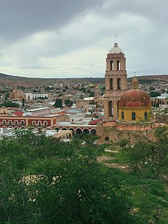
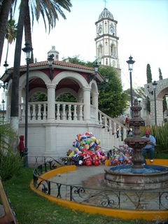
Temple of San Francisco de Asís. The most representative building of the municipality of Huanusco is, invariably, the temple erected to the Patron Saint Francisco de Asís, whose construction began in 1970. In his book The church of Huanusco, Leobardo Viramontes Flores, says that << the front [...] It is of the Tuscan order in its columns, as well as its altar, but Corinthian as far as Asis capitals are concerned. Currently the altar has been modified, for which part of the old one was destroyed, something that is regrettable since it should have been preserved as it was >>.
Other places. In addition to the municipal seat and the communities mentioned above, we find in Huanusco several tourist places such as the Dam and the Eye of Water, both on the banks of the Juchipila river as well as in the mountains that surround it, the Matrera Pile, Charco de la Campana, The Hillside of the Sálate; El Charco de las Figuras, Hot Springs in La Higuera and Los Ahuehuetes. The inconvenience to visit these sites is the lack of infrastructure and professional attention in the tourist field.
Famous Characters
Calixto Medina Medina. This was Huanusco's first qualified doctor; He served as federal deputy and senator of the Republic. It was characterized by its high philanthropic and humanitarian spirit. The Jalpa hospital is named after him.
Bonifacio Villegas. This man was a soldier who participated in several combats; In 1920 he was appointed head of the committee in the land petition, which led him to the enmity of the landowners and cristeros of the region. He lost his life in a fight in Los Tepetates, in the Sierra de Morones.
Arturo Reyes Viramontes. He is a character who has numerous unpublished books (didactic, historical, anecdotal), which have served as a basis for shaping the history of Huanusco and Jalpa; that is, he was the first historian of these municipalities. He was also the initiator of the community museums of Jalpa and Huanusco, the first of which bears his name.
Jose Maria Benitez. This character is a writer. I collaborate in Excelsior and in the supplement “Mexican Magazine of Culture” of El Nacional. He was a teacher of literature, universal history and advertising. He was also a trade unionist and public official. Among his published works we find What my cat saw and other stories, belonging to the Debt Debt Collection, edited by the National Autonomous University of Mexico. In this work, María de Lourdes Franco Bagnouls, compiler of the stories, tells us the author: manages an extensive record of human behavior and condition, as well as the aesthetic orientations at his disposal; in the same way that it raises the most negative situations, it also reaches moments of extreme sublimity. His stories may or may not like a reader who is constantly attacked by the author but will recognize, no doubt in them the office exercised with skill and forcefulness.
Gastronomy
Huanusco's food is diverse in colors, smells and flavors. Among the most representative dishes of the region and the municipality, we find the traditional pozole of red corn; there are also gorditas filled with curd, chilaquiles, chopped butter, red corn and tacazotas, which are tender corn gorditas; Red, deaf, green and sugar chili tamales; suegras or quesadillas of pumpkin flower, hitlacoche and jazpite; peanut atole, white, fat, abrojo and mesquite; red enchiladas, often, sweet and double mole, pipian, roast pork, tejuino, birria, pumpkin patties, mexquitamal, pumpkin seed hash, charrascas or charamuscas, corn soup, ponteduro, ozote mushroom stew, tea cuachalala, temachaca and pipitoria broth.
Related Research Articles
Zacatecas is the principal city within the municipality in Mexico of the same name, and the capital and the largest city of the state of Zacatecas. Located in north-central Mexico, the city had its start as a Spanish mining camp in the mid-16th century. Native Americans had already known about the area's rich deposits of silver and other minerals. Due to the wealth that the mines provided, Zacatecas quickly became one of the most important mining cities in New Spain. The area saw battles during the turbulent 19th century, but the next major event was the Battle of Zacatecas during the Mexican Revolution when Francisco Villa captured the town, an event still celebrated every anniversary. Today, the colonial part of the city is a World Heritage Site, due to the Baroque and other structures built during its mining days. Mining still remains an important industry. The name Zacatecas is derived from the Zacateco people and has its roots in Nahuatl. The name means "people of the grasslands".
Ixtlahuacán del Rio is a town and municipality in the center of the Mexican state of Jalisco, a little less than 50 kilometres (31 mi) from state capital Guadalajara. It stands at 1,655 metres (5,430 ft) above sea level; the climate is semi-arid, with a mild winter and an average annual temperature of 19 °C (66 °F).
Tepatitlán de Morelos is a city and municipality founded in 1530, in the central Mexican state of Jalisco. It is located in the area known as Los Altos de Jalisco, about 70 km east of state capital Guadalajara. It is part of the macroregion of the Bajío. Its surrounding municipality of the same name had an area of 1,532.78 km2. Its most distinctive feature is the Baroque-style parish church in the centre of the city dedicated to Saint Francis of Assisi. Other notable sites include the kiosk that sits on the Plaza de Armas in downtown, the Temple of San Antonio, and the city hall. The latter is one of the most distinctive features in the city, built in neoclassic-baroque style.
Sombrerete is a town and municipality located in the northwest of the Mexican state of Zacatecas, bordering the state of Durango.
Benito Juárez Municipality is a Mexican municipality located in the southern extreme of the state of Zacatecas on the edge of the Canyon of Tlaltenango.
Jalpa is a town located in the Mexican state of Zacatecas, close to the border with Jalisco and Aguascalientes and about a two hours drive south of the capital city, Zacatecas. Jalpa is a colonial-style city, with cobble stone streets, narrow walkways, two main churches: El Señor de Jalpa and La Parroquia de San Antonio, and two plazas. Jalpa was modeled by the French in the 19th century. In the middle of the plaza is a kiosk which remains in good shape today, after hundreds of years. Most houses are painted in bright colors just as in colonial times. The houses are made of adobe and share common walls and most have flat roofs.
Jerécuaro is a Mexican city located in the lowlands of the state of Guanajuato. The municipality has an area of 828.3 square kilometres and is bordered to the north by Apaseo el Alto, to the east by Coroneo and the state of Querétaro, to the south by Tarandacuao, to the southwest with Acámbaro, and to the northwest with Tarimoro. The municipality had 55,311 inhabitants according to the 2005 census. The municipal president of Jerécuaro and its many smaller outlying communities is C.Jaime García Cardona.
Chalchihuites is a municipality in the Mexican state of Zacatecas in northwest Mexico. The archaeological site of Altavista, at Chalchihuites, is located 137 miles to the northwest of the city of Zacatecas and 102 miles southeast of the city of Durango. Located to the west of Sombrerete in the northwestern corner of the Zacatecas state, it is believed that the site was a cultural oasis that was occupied more or less continuously from AD 100 to AD 1400.
Teúl de González Ortega Municipality is a town and municipality located in the south of the Mexican state of Zacatecas, between the state capital of Zacatecas and the city of Guadalajara. Unlike most of the rest of the state, its economy has been based on agriculture and livestock, rather than mining, and it is noted for its production of agave and mezcal. The town has been named a Pueblo Mágico to promote a tourism industry.
Tlatlaya is one of 125 municipalities of the State of Mexico in Mexico. The municipal seat is the town of Tlatlaya which is the eleventh largest town in the municipality. The word “Tlatlaya” means when the hearth is black and red.
Ixtlahuaca de Rayón is the municipal seat and 5th largest city in the municipality of Ixtlahuaca north of Toluca in the northwest part of the State of Mexico, in Mexico. The distance between Mexico City and Ixtlahuaca is 32 km. The name Ixthahuaca comes from Náhuatl and means plains without trees. The city and municipality were officially established by decree on November 14, 1816 by the Congress of the State of Mexico.
Zacatecas, officially the Free and Sovereign State of Zacatecas, is one of the 31 states of Mexico. It is divided into 58 municipalities and its capital city is Zacatecas.
Atotonilco El Alto is a town and municipality, in Jalisco in Los Altos (Jalisco) region in central-western Mexico. The municipality covers an area of 638.15 km2.
El Teúl is an important archaeological Mesoamerican site located on a hill with the same name in the Teúl Municipality in the south of the Zacatecas State, Mexico, near the Jalisco State.
Santa María de la Paz is a municipality in the Mexican state of Zacatecas, located approximately 165 kilometres (103 mi) southwest of the state capital of Zacatecas City.
Juchipila is a municipality in the Mexican state of Zacatecas, located approximately 160 kilometres (99 mi) southwest of the state capital Zacatecas City.
Genaro Codina is a municipality in the Mexican state of Zacatecas, located approximately 30 kilometres (19 mi) southwest of the state capital of Zacatecas City. It is named after Genaro Codina, musician and composer of the state anthem, the March of Zacatecas.
Mezquital del Oro is a municipality in the Mexican state of Zacatecas, located approximately 190 kilometres (120 mi) southwest of Zacatecas City, the state capital.
Trinidad García de la Cadena is a municipality in the Mexican state of Zacatecas, located approximately 200 kilometres (120 mi) southwest of Zacatecas City, the state capital. It is named after General Trinidad García de la Cadena, governor of Zacatecas from 1869 to 1870 and from 1876 to 1880.
References
Content obtained from booked titled Los municipios de Zacatecas, memoria y patrimonio. Huanusco part written by Federico Priapo Chew Araiza, typed here by Jose Garcia, First Edition
This page is based on this Wikipedia article Text is available under the CC BY-SA 4.0 license; additional terms may apply. Images, videos and audio are available under their respective licenses.