General Francisco R. Murguía | |
---|---|
![]() View of Nieves | |
![]() Location of General Francisco R. Murguía in Zacatecas | |
Coordinates: 23°59′38″N103°01′10″W / 23.99389°N 103.01944°W [1] | |
Country | ![]() |
State | ![]() |
Established | 17 January 1825 |
Seat | Nieves |
Government | |
• President | Javier García |
Area | |
• Total | 5,034.261 km2 (1,943.739 sq mi) |
Elevation [1] (of seat) | 1,910 m (6,270 ft) |
Population (2010 Census) [2] | |
• Total | 21,974 |
• Estimate (2015 Intercensal Survey) [3] | 21,809 |
• Density | 4.4/km2 (11/sq mi) |
• Seat | 5,653 |
Time zone | UTC-6 (Central) |
• Summer (DST) | UTC-5 (Central) |
Postal codes | 98350–98390 [4] |
Area code | 498 |
Website | Official website |
General Francisco R. Murguía is a municipality in the Mexican state of Zacatecas, located approximately 140 kilometres (87 mi) north of the state capital of Zacatecas City. Its municipal seat is located in Nieves.
The municipality of Francisco R. Murguía is located at an elevation between 1,500 and 2,700 metres (4,900–8,900 ft) on the Mexican Plateau in northern Zacatecas. It borders the Zacatecan municipalities of Mazapil to the northeast, Villa de Cos to the southeast, Río Grande to the southwest, and Juan Aldama to the west. [5] It also borders three municipalities of Durango to the north and northwest: Santa Clara, General Simón Bolívar, and San Juan de Guadalupe. The municipality covers an area of 5,034.261 square kilometres (1,943.739 sq mi) [2] and comprises 6.6% of the state's area. [5]
As of 2009, the land cover in Francisco R. Murguía comprises matorral (53%), grassland (24%), and mezquital (2%). Another 21% of the land is used for agriculture. [5] The municipality lies in the endorheic basin of the Aguanaval River, which flows south to north through the municipality. [6] The small mountain range called the Sierra de Guadalupe rises in the south-central part of the municipality, and was formerly exploited for its deposits of copper, antimony and mercury. [7]
Francisco R. Murguía has a semi-arid climate with dry winters. [6] Average temperatures in the municipality range between 12 and 20 °C (54–68 °F), and average annual precipitation ranges between 200 and 500 millimetres (7.9–19.7 in). [5]
Climate data for Nieves weather station at 24°00′05″N103°01′10″W / 24.00139°N 103.01944°W , 1913 m above sea level (1981–2010 averages, 1951–2010 extremes) | |||||||||||||
---|---|---|---|---|---|---|---|---|---|---|---|---|---|
Month | Jan | Feb | Mar | Apr | May | Jun | Jul | Aug | Sep | Oct | Nov | Dec | Year |
Record high °C (°F) | 29.5 (85.1) | 32.5 (90.5) | 35.0 (95.0) | 37.0 (98.6) | 38.0 (100.4) | 39.0 (102.2) | 38.0 (100.4) | 36.0 (96.8) | 35.0 (95.0) | 33.5 (92.3) | 29.5 (85.1) | 29.5 (85.1) | 39.0 (102.2) |
Mean daily maximum °C (°F) | 20.4 (68.7) | 23.1 (73.6) | 26.1 (79.0) | 29.0 (84.2) | 31.8 (89.2) | 30.7 (87.3) | 28.5 (83.3) | 28.1 (82.6) | 26.5 (79.7) | 25.7 (78.3) | 23.5 (74.3) | 21.4 (70.5) | 26.2 (79.2) |
Daily mean °C (°F) | 11.6 (52.9) | 13.8 (56.8) | 16.3 (61.3) | 19.3 (66.7) | 22.3 (72.1) | 22.6 (72.7) | 21.3 (70.3) | 20.8 (69.4) | 19.6 (67.3) | 17.6 (63.7) | 14.6 (58.3) | 12.1 (53.8) | 17.7 (63.9) |
Mean daily minimum °C (°F) | 2.8 (37.0) | 4.6 (40.3) | 6.5 (43.7) | 9.5 (49.1) | 12.8 (55.0) | 14.5 (58.1) | 14.1 (57.4) | 13.5 (56.3) | 12.7 (54.9) | 9.5 (49.1) | 5.7 (42.3) | 2.7 (36.9) | 9.1 (48.4) |
Record low °C (°F) | −8.0 (17.6) | −5.5 (22.1) | −6.0 (21.2) | −0.5 (31.1) | 2.5 (36.5) | 5.0 (41.0) | 6.0 (42.8) | 6.0 (42.8) | 4.0 (39.2) | −2.5 (27.5) | −4.5 (23.9) | −9.5 (14.9) | −9.5 (14.9) |
Average precipitation mm (inches) | 9.9 (0.39) | 7.3 (0.29) | 2.1 (0.08) | 5.9 (0.23) | 16.8 (0.66) | 72.9 (2.87) | 77.0 (3.03) | 80.5 (3.17) | 74.4 (2.93) | 35.3 (1.39) | 10.3 (0.41) | 12.9 (0.51) | 405.3 (15.96) |
Average rainy days (≥ 1 mm) | 1.7 | 0.9 | 0.6 | 1.4 | 2.4 | 8.3 | 10.8 | 10.9 | 8.9 | 4.4 | 1.4 | 1.7 | 53.4 |
Source: Servicio Meteorológico Nacional [8] [9] |
Prior to the arrival of the Spanish, the area in what is now the municipality of General Francisco R. Murguía was inhabited by Chichimeca peoples. The expedition of Francisco de Ibarra arrived in the area on 5 August 1558, naming it Santa Maria de las Nieves after the feast on that day. In the 18th century it took the name of Real de Minas in reference to the local mining activities, but was renamed Nieves later in the same century. [6]
After the independence of Mexico, Nieves was one of the original partidos named in Zacatecas's state constitution first enacted on 17 January 1825. It became a free municipality on 19 August 1916. In 1964, the municipality was renamed in honour of General Francisco Murguía , who was born in Mazapil and fought in the Mexican Revolution. [6] [10]
The municipal government of Francisco R. Murguía comprises a president, a councillor (Spanish: síndico), and thirteen trustees (regidores), eight elected by relative majority and five by proportional representation. [6] The current president of the municipality is Javier Garcia (2021). [11]
In the 2010 Mexican Census, the municipality of Francisco R. Murguía recorded a population of 21,974 inhabitants living in 5427 households. [12] The 2015 Intercensal Survey estimated a population of 21,809 inhabitants in Francisco R. Murguía. [3]
INEGI lists 76 localities in the municipality, [1] of which only the municipal seat Nieves is classified as urban. It recorded a population of 5653 inhabitants in the 2010 Census. [12]
The main economic activity in Francisco R. Murguía is agriculture. [6] The main crops grown are forage oats, beans, and corn. [13] Cattle, sheep and goats are also raised. [7]
Mazapil is a municipality in the Mexican state of Zacatecas and the state's largest municipality by area. The Peñasquito mine, Mexico's largest gold mine, is located in this sparsely populated municipality.
Río Grande is a municipality in the Mexican state of Zacatecas.
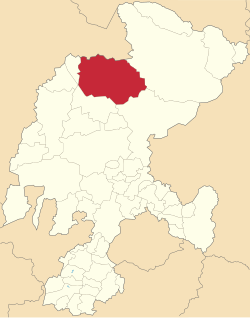
Jilotepec is a municipality in the Mexican state of Veracruz, located 11 kilometres (6.8 mi) north-northwest of the state capital Xalapa.
Citlaltépetl is a municipality in the Mexican state of Veracruz, located 223 kilometres (139 mi) northwest of the state capital of Xalapa and 99 kilometres (62 mi) south of the city of Tampico, Tamaulipas.
Epitacio Huerta is a municipality in the Mexican state of Michoacán. It is located approximately 105 kilometres (65 mi) northeast of the state capital of Morelia. It is named after General Epitacio Huerta, who fought in the Mexican–American War and under Juan Álvarez in the Revolution of Ayutla, and served as governor of Michoacán from 1858 to 1862.
Huaniqueo is a municipality in the Mexican state of Michoacán. It is located approximately 40 kilometres (25 mi) northwest of the state capital of Morelia.
Jiménez is a municipality in the Mexican state of Michoacán. It is located approximately 65 kilometres (40 mi) west of the state capital of Morelia.
Tzitzio is a municipality in the Mexican state of Michoacán, located approximately 30 kilometres (19 mi) southeast of the state capital of Morelia.
Tanhuato is a municipality in the Mexican state of Michoacán. It is located approximately 135 kilometres (84 mi) northwest of the state capital of Morelia.
Miguel Auza is a municipality in the Mexican state of Zacatecas, located approximately 190 kilometres (120 mi) northwest of the state capital of Zacatecas City.
Sain Alto is a municipality in the Mexican state of Zacatecas, located approximately 110 kilometres (68 mi) northwest of the state capital of Zacatecas City.
Morelos is a semi-urban municipality in the Zacatecas metropolitan area in the Mexican state of Zacatecas.
Villa González Ortega is a municipality in the Mexican state of Zacatecas, located approximately 70 kilometres (43 mi) southeast of the state capital of Zacatecas City. It is named after Jesús González Ortega.
Noria de Ángeles is a municipality in the Mexican state of Zacatecas, located approximately 75 kilometres (47 mi) southeast of the state capital of Zacatecas City.
Luis Moya is a municipality in the Mexican state of Zacatecas, located approximately 50 kilometres (31 mi) southeast of the state capital at Zacatecas. It is named after Luis Moya (1855–1911), a colonel in the Mexican Revolution who was posthumously given the rank of brigadier general in 1939.
Genaro Codina is a municipality in the Mexican state of Zacatecas, located approximately 30 kilometres (19 mi) southwest of the state capital at the city of Zacatecas. It is named after Genaro Codina, musician and composer of the state anthem, the "March of Zacatecas".
Mezquital del Oro is a municipality in the Mexican state of Zacatecas, located approximately 190 kilometres (120 mi) southwest of Zacatecas City, the state capital.
Trinidad García de la Cadena is a municipality in the Mexican state of Zacatecas, located approximately 200 kilometres (120 mi) southwest of Zacatecas City, the state capital. It is named after General Trinidad García de la Cadena, governor of Zacatecas from 1869 to 1870 and from 1876 to 1880.
El Salvador is a municipality in the Mexican state of Zacatecas, located approximately 260 kilometres (160 mi) northeast of Zacatecas City, the state capital.
Susticacán is a municipality in the Mexican state of Zacatecas, located approximately 55 kilometres (34 mi) west of Zacatecas City, the state capital.