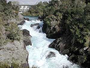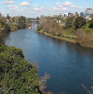
The Waikato River is the longest river in New Zealand, running for 425 kilometres (264 mi) through the North Island. It rises on the eastern slopes of Mount Ruapehu, joining the Tongariro River system and flowing through Lake Taupō, New Zealand's largest lake. It then drains Taupō at the lake's northeastern edge, creates the Huka Falls, and flows northwest through the Waikato Plains. It empties into the Tasman Sea south of Auckland, at Port Waikato. It gives its name to the Waikato region that surrounds the Waikato Plains. The present course of the river was largely formed about 17,000 years ago. Contributing factors were climate warming, forest being reestablished in the river headwaters and the deepening, rather than widening, of the existing river channel. The channel was gradually eroded as far up river as Piarere, leaving the old Hinuera channel through the Hinuera Gap high and dry. The remains of the old course are seen clearly at Hinuera, where the cliffs mark the ancient river edges. The Waikato's main tributary is the Waipā River, which converges with it at Ngāruawāhia.

The Taupō Volcanic Zone (TVZ) is a volcanic area in the North Island of New Zealand that has been active for at least the past two million years and is still highly active. Mount Ruapehu marks its south-western end and the zone runs north-eastward through the Taupō and Rotorua areas and offshore into the Bay of Plenty. It is part of a larger Central Volcanic Region that extends to the Coromandel Peninsula and has been active for four million years. The zone is contained within the tectonic intra-arc continental Taupō Rift and this rift volcanic zone is widening unevenly east–west with the greatest rate of widening at the Bay of Plenty coast, the least at Mount Ruapehu and a rate of about 8 mm (0.31 in) per year at Taupō. The zone is named after Lake Taupō, the flooded caldera of the largest volcano in the zone, the Taupō Volcano and contains a large central volcanic plateau as well as other landforms.

Wairakei is a small settlement, and geothermal area 8-kilometres north of Taupō, in the centre of the North Island of New Zealand, on the Waikato River. It is part of the Taupō Volcanic Zone and features several natural geysers, hot pools. boiling mud pools, and the Wairakei Power Station, a major geothermal electric power generating station.
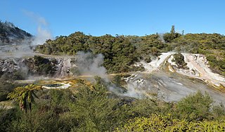
Orakei Korako is a highly active geothermal area most notable for its series of fault-stepped sinter terraces, located in a valley north of Taupō on the banks of the Waikato River in the Taupō Volcanic Zone, New Zealand. It is also known as "The Hidden Valley".

The Tongariro River is a river in the North Island of New Zealand. The part of the Waikato River from the Waihohonu Stream, down to Lake Taupō, was formally named the Tongariro River in 1945. The river originates in the Central Plateau of the North Island where it is fed by numerous tributaries that flow off the surrounding hill ranges and mountains such as Mount Ruapehu. It then winds its way north, through the township of Tūrangi before entering Lake Taupō via a number of river mouths. The minimum volume of water flowing down the lower Tongariro River ranges from approximately 16 cubic metres per second (570 cu ft/s) to 21 cubic metres per second (740 cu ft/s). This volume can substantially increase due to catchment of rainfall by the surrounding mountains and hill ranges.
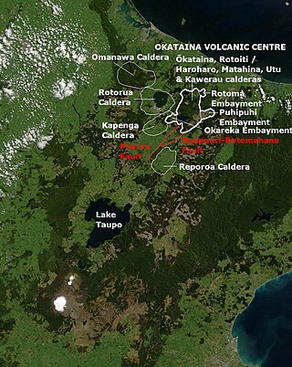
The Reporoa Caldera is a 10 km by 15 km caldera in New Zealand's Taupō Volcanic Zone located in the Taupō-Reporoa Basin. It formed some 280,000 years ago, in a large eruption that deposited approximately 100 km3 of tephra, forming the Kaingaroa Ignimbrite layer. The ignimbrite sheet extends up to 15 km (9.3 mi) to the east.
Tauhara is a suburb and geothermal area of Taupō in the Waikato region of New Zealand's North Island.
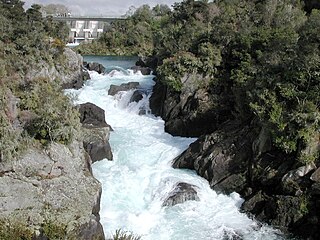
Aratiatia Power Station is a hydroelectric power station on the Waikato River, in the North Island of New Zealand. It is the first hydroelectric power station on the Waikato River, and is located 13 kilometres (8.1 mi) downstream of Lake Taupō. Aratiatia is owned and operated by Mercury Energy.

Ātiamuri Power Station is a hydroelectric power station on the Waikato River, in the North Island of New Zealand. It is the third of eight hydroelectric power stations on the Waikato River. The station can easily be seen from State Highway 1 between Taupō and Tokoroa.
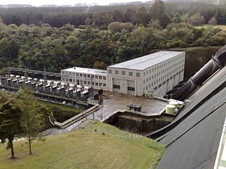
Whakamaru Power Station is a hydroelectric power station on the Waikato River, in the North Island of New Zealand. It is the fourth hydroelectric power station on the Waikato River.
The Hinemaiaia Stream is a river of the central North Island of New Zealand. It flows northwest from Kaimanawa Forest Park, flowing into the eastern shore of Lake Taupō at Hatepe, halfway between Taupō and Tūrangi. It is a popular Fly fishing stream with good numbers of Rainbow trout spawning in the winter months of June through to September.

The Wairakei River or Wairakei Stream is a river of the Waikato Region of New Zealand's North Island. It flows southeast to meet the Waikato River, which it does at the town of Wairakei, 10 kilometres north of Taupō.

The Waikato River Trails is a combined walk- and cycleway along the Waikato River. Originally conceived and started by local politicians and trustees, in 2009 the trails became one of the seven Quick Start Projects that form the beginning of the New Zealand Cycle Trail. The trail is proposed to be 100 km long, out of which 50 km existed before the NZCT scheme was created. In mid-2011, work on the last sections of the cycle trail project sections was begun, while the official grand opening occurred early November 2011.

Iwitahi is a rural locality in the Taupō District and Bay of Plenty Region of New Zealand's North Island. It is situated on State Highway 5 between Taupō and Napier, about 20 km southeast of Taupō. It is a farming area, largely surrounded by forest, close to the plains of the upper Rangitaiki River. The locality was formerly known as Iwatahi.

The Huka Prawn Park is an aquaculture venture and tourist attraction located 10 minutes north of Taupō. It was started in 1987, and is currently New Zealand's only prawn farm. It can produce over 30 tonnes of prawns a year.
Piarere is a locality in the Waikato region of New Zealand's North Island. It is situated on State Highway 29 close to its junction with State Highway 1, close to the shore of Lake Karapiro. The nearest towns are Tīrau, six kilometres to the southeast, Matamata, 10 kilometres to the northeast, and Cambridge, 10 kilometres to the northwest.
Motutere is a small township on the southeastern shore of Lake Taupō in New Zealand's Waikato region. It lies on Motutere Bay, close to the popular diving location, Te Poporo / Bulli Point, and approximately halfway between Taupō and Tūrangi, to both of which it is connected by SH1.

The Maroa Caldera is approximately 16 km × 25 km in size and is located in the north-east corner of the earlier Whakamaru caldera in the Taupō Volcanic Zone in the North Island of New Zealand.
The Taupō Fault Belt contains many almost parallel active faults, and is located in the Taupō Rift of the central North Island of New Zealand geographically between Lake Taupō and the lakes of Rotorua, Tarawera, Rotomahana and Rerewhakaaitu. The potential active fault density is very high, with only 0.1 to 1 km separating the north-east to south-west orientated normal fault strands on detailed mapping of part of the belt. The Waikato River bisects the western region of the belt.
