
Hamilton is an inland city in the North Island of New Zealand. Located on the banks of the Waikato River, it is the seat and most populous city of the Waikato region. With a territorial population of 185,300, it is the country's fourth most-populous city. Encompassing a land area of about 110 km2 (42 sq mi), Hamilton is part of the wider Hamilton Urban Area, which also encompasses the nearby towns of Ngāruawāhia, Te Awamutu and Cambridge. In 2020, Hamilton was awarded the title of most beautiful large city in New Zealand.

The Waikato River is the longest river in New Zealand, running for 425 kilometres (264 mi) through the North Island. It rises on the eastern slopes of Mount Ruapehu, joining the Tongariro River system and flowing through Lake Taupō, New Zealand's largest lake. It then drains Taupō at the lake's northeastern edge, creates the Huka Falls, and flows northwest through the Waikato Plains. It empties into the Tasman Sea south of Auckland, at Port Waikato. It gives its name to the Waikato region that surrounds the Waikato Plains. The present course of the river was largely formed about 17,000 years ago. Contributing factors were climate warming, forest being reestablished in the river headwaters and the deepening, rather than widening, of the existing river channel. The channel was gradually eroded as far up river as Piarere, leaving the old Hinuera channel through the Hinuera Gap high and dry. The remains of the old course are seen clearly at Hinuera, where the cliffs mark the ancient river edges. The Waikato's main tributary is the Waipā River, which converges with it at Ngāruawāhia.
Ngāruawāhia is a town in the Waikato region of the North Island of New Zealand. It is located 20 kilometres (12 mi) north-west of Hamilton at the confluence of the Waikato and Waipā Rivers, adjacent to the Hakarimata Range. Ngāruawāhia is in the Hamilton Urban Area, the fourth largest urban area in New Zealand. The location was once considered as a potential capital of New Zealand.

The Auckland Harbour Bridge is an eight-lane motorway bridge over the Waitematā Harbour in Auckland, New Zealand. It joins St Marys Bay on the Auckland city side with Northcote on the North Shore side. It is part of State Highway 1 and the Auckland Northern Motorway. The bridge is operated by the NZ Transport Agency (NZTA). It is the second-longest road bridge in New Zealand, and the longest in the North Island.

The Waikato Times is a daily newspaper published in Hamilton, New Zealand and owned by media business Stuff Ltd. It has a circulation to the greater Waikato region and became a tabloid paper in 2018.

State Highway 1 is the longest and most significant road in the New Zealand road network, running the length of both main islands. It appears on road maps as SH 1 and on road signs as a white number 1 on a red shield, but it has the official designations SH 1N in the North Island, SH 1S in the South Island.

Waikato Museum is a regional museum located in Hamilton, New Zealand. The museum manages ArtsPost, a shop and gallery space for New Zealand art and design. Both are managed by the Hamilton City Council. Outside the museum is The Tongue of The Dog, a sculpture by Michael Parekōwhai that has helped to increase visitor numbers. The sculpture was commissioned by MESH Sculpture Trust, Hamilton.

The Auckland Northern Motorway in the Auckland Region of New Zealand links Central Auckland and Warkworth in the former Rodney District via the Hibiscus Coast and North Shore. It is part of State Highway 1.

Rototuna is a suburb in northern Hamilton, New Zealand, east of Flagstaff. It is one of the newest and fastest-growing suburbs in Hamilton, along with neighbouring Huntington and Flagstaff.
The Waikato Expressway is a dual carriageway section of State Highway 1 in New Zealand's Waikato region. Constructed in stages, it forms part of the link between Auckland and Hamilton. Currently stretching from Auckland to south of Cambridge, the first section of the highway was built in 1993. Throughout its lifetime, it has undergone many upgrades to optimise traffic flow throughout the Waikato region, including various bypasses of many towns in the region, culminating with Hamilton in 2022.
Fairfield Bridge is a tied-arch bridge on the Waikato River in Fairfield, Hamilton, New Zealand. It is one of six bridges in the city. It spans from River Road, on the east bank of the river, to Victoria Street, on the west side.

Pukete is a 1970s riverside suburb in northwestern Hamilton in New Zealand.

Harrowfield is a suburb in eastern Hamilton in New Zealand. It was built in about 1991.

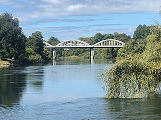
Victoria Bridge is a steel arch bridge in Hamilton, New Zealand. The bridge has a Category I heritage protection.
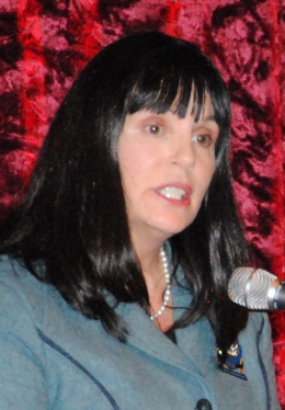
Julie Hardaker was the Mayor of Hamilton, New Zealand, from October 2010 to October 2016. Born in New Zealand, she was self-employed in Australia in the 1980s. After graduating from the University of Waikato, she joined the Hamilton law firm McCaw Lewis Chapman and became a partner and held senior management roles. She is involved in various community and business organisations at a governance level. As a political novice, she defeated former Mayor and experienced politician Bob Simcock in the 2010 New Zealand local government elections. Hardaker was re-elected in the 2013 election beating her main rival Ewan Wilson, with a majority of 2911 votes, becoming the first mayor of Hamilton in nearly two decades to survive their first term in office. She was returned to power with an increased majority, capturing 43.6% of the valid mayoral votes cast.
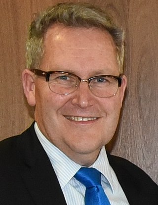
The 2016 Hamilton City mayoral election is part of the New Zealand local elections and held to determine the next mayor of the Hamilton City Council. The incumbent Julie Hardaker, who was first elected in the 2010 mayoral election did not stand for re-election. Confirmed candidates included current Waikato Regional Council chair Paula Southgate, East Ward Councillor Rob Pascoe, West Ward Councillor Andrew King, and former business manager at Hamilton City Council Chris Simpson. Andrew King won with a nine-vote margin, amended to 6 votes in a recount.
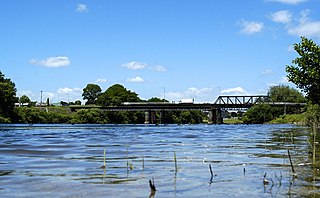
Horotiu is a small township on the west bank of the Waikato River in the Waikato District of New Zealand. It is on the Waikato Plains 13 km (8.1 mi) north of Hamilton and 5 km (3.1 mi) south of Ngāruawāhia. From early in the 20th century it developed around a freezing works and other industries.

Whitiora Bridge is a prestressed concrete box girder bridge in Hamilton, New Zealand, spanning the Waikato River. It cost $2.35m, or $3.4m including the approach roads, and was opened at the start of a weekend of Centennial celebrations, on 11 February 1978, by representatives of Māori, Government and City, Dame Te Atairangikaahu, Venn Young and Ross Jansen.
Newstead is a rural settlement on the outskirts of Hamilton, in the Waikato District and Waikato region of New Zealand's North Island.

