Related Research Articles

Waikato is a region of the upper North Island of New Zealand. It covers the Waikato District, Waipa District, Matamata-Piako District, South Waikato District and Hamilton City, as well as Hauraki, Coromandel Peninsula, the northern King Country, much of the Taupō District, and parts of the Rotorua Lakes District. It is governed by the Waikato Regional Council.

The Waikato River is the longest river in New Zealand, running for 425 kilometres (264 mi) through the North Island. It rises on the eastern slopes of Mount Ruapehu, joining the Tongariro River system and flowing through Lake Taupō, New Zealand's largest lake. It then drains Taupō at the lake's northeastern edge, creates the Huka Falls, and flows northwest through the Waikato Plains. It empties into the Tasman Sea south of Auckland, at Port Waikato. It gives its name to the Waikato region that surrounds the Waikato Plains. The present course of the river was largely formed about 17,000 years ago. Contributing factors were climate warming, forest being reestablished in the river headwaters and the deepening, rather than widening, of the existing river channel. The channel was gradually eroded as far up river as Piarere, leaving the old Hinuera channel through the Hinuera Gap high and dry. The remains of the old course are seen clearly at Hinuera, where the cliffs mark the ancient river edges. The Waikato's main tributary is the Waipā River, which converges with it at Ngāruawāhia.

The Waipā River is in the Waikato region of the North Island of New Zealand. The headwaters are in the Rangitoto Range east of Te Kuiti. It flows north for 115 kilometres (71 mi), passing through Ōtorohanga and Pirongia, before flowing into the Waikato River at Ngāruawāhia. It is the Waikato's largest tributary. The Waipā's main tributary is the Puniu River.

The Piako River is a lowland river system that drains into the Firth of Thames on the North Island of New Zealand. Together with the Waihou River, it is one of the two main rivers systems which drains the Hauraki Plains. It is the dominant river system in the Matamata-Piako District, and on its journey it passes through the towns of Morrinsville and Ngatea.

The Hauraki Plains are a geographical feature and non-administrative area located in the northern North Island of New Zealand, at the lower (northern) end of the Thames Valley. They are located 75 kilometres south-east of Auckland, at the foot of the Coromandel Peninsula and occupy the southern portion of a rift valley bounded on the north-west by the Hunua Ranges, to the east by the Coromandel and Kaimai ranges and to the west by a series of undulating hills which separate the plains from the much larger plains of the Waikato River. Broadly, the northern and southern parts of the Hauraki Plains are administered by the Hauraki District and the Matamata-Piako District respectively.

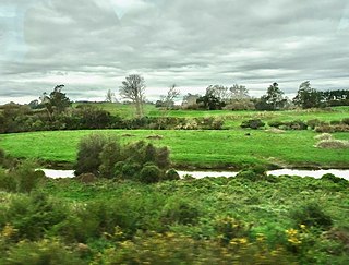
The Waikato Plains form a large area of low-lying land in the northwest of the North Island of New Zealand. They are the alluvial plains of the Waikato River, the country's longest river with a length of 425 km (264 mi).

The Kopuatai Peat Dome is a large peatland complex on the Hauraki Plains in the North Island of New Zealand. It consists of two raised domes, one in the north and the other in the south, that are up to three metres higher at the center than at the edge. The 10,201 hectares wetland contains the largest intact raised bog in New Zealand and was listed under the Ramsar Convention in 1989 as a Wetland of International Importance. Most of the wetland is ombrotrophic, meaning it receives water and nutrient inputs solely from rain and is hydrologically isolated from the surrounding canals and rivers. Locally, a popular misconception persists that water flows from the nearby Piako River into the bog and that the wetland acts as a significant store for floodwater.
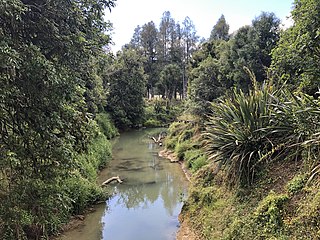
The Mangapu River is a river of the Waikato region of New Zealand's North Island. It has its sources in numerous streams which flow generally northwards from the King Country south of Te Kuiti, the longest of which is the Mangaokewa Stream. These streams join to form the Mangapu close to Te Kuiti, and from here the river flows north, passing close to the east of Waitomo Caves, where the Mangapu caves have the largest entrance in the North Island, before flowing into the Waipā River at Ōtorohanga.
The Puniu River is a river of the Waikato region of New Zealand's North Island. As a tributary of the Waipā River, and at a length of 57 kilometres (35 mi), it is one of the longest secondary tributaries in New Zealand.
The Mangapiko Stream is mostly a low-lying peat stream that flows through the heart of the Waipa district, Waikato. The stream begins near the summit of Mt Maungatautari and then weaves westward through low-lying dairy farmland and eventually becomes the tributary of the Waipā River in Pirongia.

Lake Ngaroto is a peat lake in Waipa District of New Zealand.

The Whangamarino Wetland in the Waikato District is the second largest wetland complex of the North Island of New Zealand. Encompassing a total area of more than 7200 hectares, the Department of Conservation Te Papa Atawhai manages 5,923 hectares of peat bog, swamp, mesotrophic lags, open water and river systems listed as a wetland of international importance under the Ramsar Convention. Fish and Game New Zealand are the second largest landowner, managing 748 hectares of the wetland primarily as gamebird hunting habitat.
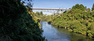
Victoria Bridge is a hinged braced arch, bridge in New Zealand, linking Cambridge with Leamington and spanning the Waikato River.
Lake Whangape is shallow, supertrophic, lateral and the second largest lake in the lower Waikato River basin in New Zealand. One source said the name translated to 'a large sheet of water', another that it was a chief's name.
The Mangatangi River, or Mangatangi Stream, originates on the eastern slopes of the Hunua Ranges in New Zealand and flows roughly southwards until it is joined by the Ruaotehuia Stream just north of State Highway 2 between Mangatāwhiri and Maramarua, where it becomes the Maramarua River. Mangatangi can be translated as manga tangi to stream of weeping, or as rippling stream, or babbling brook.
Lake Opuatia is a small lake in the much larger Opuatia wetland, which drains from the west into the Waikato River. It lies near the foot of a long valley drained by the Opuatia Stream.

Whitikahu is a settlement scattered along Whitikahu Rd in the Waikato District and Waikato region of New Zealand's North Island.

Moanatuatua scientific reserve is a 140 ha remnant of restiad (Restionaceae) peatland in the North Island of New Zealand. The bog was formerly ~ 7500 ha in size and was one of several large peatlands surrounding the city of Hamilton. Widespread drainage and conversion to agriculture has left only this small remnant of what was formerly the dominant ecosystem in the area.

Hapuakohe Range of hills is aligned north–south, between the Waikato River and the Hauraki Plains in the Waikato region of New Zealand. It is separated from the Taupiri Range by an air-gap at Mangawara, where the Waikato flowed about 20,000 years ago.

Te Rore was in the 1850s an important transhipment point on New Zealand's Waipā River, between the agriculture of the Waikato basin and its Auckland market. That was ended in 1864 by the Invasion of the Waikato, when Te Rore was, for a few months, part of the supply route to four redoubts set up nearby. It is now a rural community in the Waipa District, 6 km (3.7 mi) north of Pirongia and roughly the same distance south of Ngāhinapōuri on State Highway 39.
References
- ↑ "Waikato Regional Council's website has been updated". Archived from the original on 14 March 2012. Retrieved 22 October 2010.
- ↑ "Floodwater storage: Lower Waikato-Waipa control scheme: The economic values of Whangamarino Wetland publication". Archived from the original on 23 March 2010. Retrieved 22 October 2010.
- ↑ "The economic values of Whangamarino Wetland" (PDF). Retrieved 20 October 2023.
- ↑ "Highways Information Sheet 025-0127" (PDF). Auckland Motorways.
- ↑ "Ontrack Bridge 298 Project Award - McConnell Dowell" . Retrieved 19 November 2017.
- ↑ "Highway Information Sheet 01N-0486 (I)" (PDF). Auckland Motorways. Archived from the original (PDF) on 1 December 2017.