
Waikato is a local government region of the upper North Island of New Zealand. It covers the Waikato District, Waipa District, Matamata-Piako District, South Waikato District and Hamilton City, as well as Hauraki, Coromandel Peninsula, the northern King Country, much of the Taupō District, and parts of Rotorua District. It is governed by the Waikato Regional Council.

The Waikato River is the longest river in New Zealand, running for 425 kilometres (264 mi) through the North Island. It rises in the eastern slopes of Mount Ruapehu, joining the Tongariro River system and flowing through Lake Taupo, New Zealand's largest lake. It then drains Taupo at the lake's northeastern edge, creates the Huka Falls, and flows northwest through the Waikato Plains. It empties into the Tasman Sea south of Auckland, at Port Waikato. It gives its name to the Waikato region that surrounds the Waikato Plains. The present course of the river was largely formed about 17,000 years ago. Contributing factors were climate warming, forest being reestablished in the river headwaters and the deepening, rather than widening, of the existing river channel. The channel was gradually eroded as far up river as Piarere, leaving the old Hinuera channel through the Hinuera Gap high and dry. The remains of the old river path can be clearly seen at Hinuera where the cliffs mark the ancient river edges. The river's main tributary is the Waipa River, which has its confluence with the Waikato at Ngāruawāhia.
Franklin District was a New Zealand territorial authority that lay between the Auckland metropolitan area and the Waikato Plains. As a formal territory it was abolished on 31 October 2010 and divided between Auckland Council in the Auckland Region to the north and Waikato and Hauraki districts in the Waikato region to the south and east. The Auckland portion is now part of the Franklin ward, which also includes rural parts of the former Manukau City.

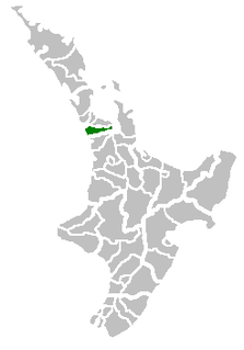
Waikato District is a territorial authority of New Zealand, in the northern part of Waikato region, North Island. Waikato District is administered by the Waikato District Council, with headquarters in Ngāruawāhia.

Lake Waikare is the largest of several shallow lakes in the upper floodplain of the Waikato River in New Zealand's North Island. It is a riverine lake, located to the east of Te Kauwhata and 40 kilometres north of Hamilton. It covers 34 km².

The Waikato Plains form a large area of low-lying land in the northwest of the North Island of New Zealand. They are the alluvial plains of the ancient Waikato River, the country's longest river that over the last 1800 years has changed course many times. In the distant past the river flowed northeast from the current Lake Karapiro, exiting near Thames, but in recent times it has flowed northwest to empty into the Tasman Sea near Port Waikato.

Forest Lake is a suburb of Hamilton in New Zealand and was added to from around the 1930s. It is centred around Forest Lake Road, which is used by around 10,000 vehicles a day.

Lake Rotoroa is a lake in Hamilton, Waikato, North Island, New Zealand. It has a surface area of about 54 hectares and an average depth of 2.4 metres. It is the home of the Hamilton Yacht Club, which holds regular sailing in the summer.

Whangape Harbour is a harbour on the west coast of Northland, New Zealand. There is a settlement called Whangape on the northern side of the harbour. Another, called Pawarenga, is located on the southern side. Kaitaia is 42 km north east.

Lake Harihari is a dune-dammed lake 10 km south of Kawhia in the Waikato region of New Zealand. Its water quality is the best amongst the Waikato dune lakes. It is ranked eighth in importance in the region. Its quality has been attributed to its remoteness.
The Awaroa River is a short river in the Waikato District of New Zealand's North Island. It flows east from its source in the dunes near Karioitahi Beach and Lake Puketi, then south from Waiuku joining with the Aka Aka Stream before reaching the Waikato River in its tidal reaches close to Motutieke Island.
Lake Whangape is shallow, supertrophic, lateral and the second largest lake in the lower Waikato River basin in New Zealand. One source said the name translated to 'a large sheet of water', another that it was a chief's name.
Te Ākau is a small farming settlement in the North Island of New Zealand, located 62 km (39 mi) north west of Hamilton, 39 km (24 mi) south west of Huntly, 45 km (28 mi) south of Port Waikato and 47 km (29 mi), or 19 km (12 mi) by ferry and road, north of Raglan. It has a hall and a school.
Lake Opuatia is a small lake in the much larger Opuatia wetland, which drains from the west into the Waikato River. It lies near the foot of a long valley drained by the Opuatia Stream.

Whitikahu is a settlement scattered along Whitikahu Rd in the Waikato District and Waikato region of New Zealand's North Island.

Lake Kimihia is located approximately 5 km to the Northeast of Huntly, in the Waikato Region of New Zealand. Lake Kimihia is a riverine lake, which links to the Waikato River.

Lake Waahi is located immediately to the west of Huntly, in the Waikato Region. Lake Waahi is a riverine lake, which links to the Waikato River by way of the short Waahi Stream. The smaller Lake Puketirini lies immediately to Waahi's southeast.
Lake Hakanoa is located within the eastern side of the Huntly township, in the Waikato Region of New Zealand. Lake Hakanoa is a riverine lake with links to the Waikato River, which lies 300 metres to the west. A smaller lake lies within wetland near the southeastern edge of Hakanoa.

The Awaroa River is a river in the Ōtorohanga District, on the west coast of New Zealand's North Island. It flows north from its source near Te Koraha, through Hauturu to Kawhia Harbour. The river passes through both pasture and indigenous forest. Over half of the river is in forest.
