Related Research Articles

Taupō, is a town on the shore of Lake Taupo, which occupies the caldera of the Taupo Volcano in the centre of the North Island of New Zealand. It is the seat of the Taupo District Council and lies in the southern Waikato Region.

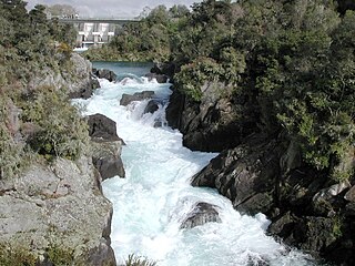
The Waikato River is the longest river in New Zealand, running for 425 kilometres (264 mi) through the North Island. It rises in the eastern slopes of Mount Ruapehu, joining the Tongariro River system and flowing through Lake Taupo, New Zealand's largest lake. It then drains Taupo at the lake's northeastern edge, creates the Huka Falls, and flows northwest through the Waikato Plains. It empties into the Tasman Sea south of Auckland, at Port Waikato. It gives its name to the Waikato region that surrounds the Waikato Plains. The present course of the river was largely formed about 17,000 years ago. Contributing factors were climate warming, forest being reestablished in the river headwaters and the deepening, rather than widening, of the existing river channel. The channel was gradually eroded as far up river as Piarere, leaving the old Hinuera channel through the Hinuera Gap high and dry. The remains of the old river path can be clearly seen at Hinuera where the cliffs mark the ancient river edges. The river's main tributary is the Waipa River, which has its confluence with the Waikato at Ngāruawāhia.
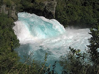
The Huka Falls are a set of waterfalls on the Waikato River that drains Lake Taupo in New Zealand.

Lake Karapiro is an artificial reservoir lake on the Waikato River, 30 kilometres (19 mi) south-east of the city of Hamilton in New Zealand's North Island. The lake was formed in 1947 by damming the Waikato River to store water for the 96-megawatt Karapiro hydroelectric power station.
Waikato Tainui, Waikato or Tainui is a group of Māori people iwi based in Waikato Region, in the western central region of New Zealand's North Island. It is part of the larger Tainui confederation of Polynesian settlers who arrived to New Zealand on the Tainui waka. The tribe is named after the Waikato River, which plays a large part in its history and culture.
Aratiatia Power Station is a hydroelectric power station on the Waikato River, in the North Island of New Zealand. It is the first hydroelectric power station on the Waikato River, and is located 13 kilometres (8.1 mi) downstream of Lake Taupo. Aratiatia is owned and operated by Mercury Energy.

The Karapiro Power Station is a hydroelectric power station on Waikato River, in the North Island of New Zealand. The power station lies on Lake Karapiro, a major rowing regatta venue. Karapiro is 30 kilometres (19 mi) upstream from the city of Hamilton and is the last of the eight hydroelectric power stations on the Waikato River.

Atiamuri Power Station is a hydroelectric power station on the Waikato River, in the North Island of New Zealand. It is the third of eight hydroelectric power stations on the Waikato River. The station can easily be seen from State Highway 1 between Taupo and Tokoroa.

Maraetai Power Station is a hydroelectric power station on the Waikato River, in the North Island of New Zealand. It is the fifth of the eight hydroelectric power stations on the Waikato River, and at 360 MW, is the largest hydroelectric station on the Waikato.
Waipapa River is the name of three rivers in New Zealand's North Island.
The Auckland Region of New Zealand is built on a basement of greywacke rocks that form many of the islands in the Hauraki Gulf, the Hunua Ranges, and land south of Port Waikato. The Waitākere Ranges in the west are the remains of a large andesitic volcano, and Great Barrier Island was formed by the northern end of the Coromandel Volcanic Zone. The main isthmus and North Shore are composed of Waitemata sandstone and mudstone, and portions of the Northland Allochthon extend as far south as Albany. Little Barrier Island was formed by a relatively isolated andesitic volcano, active around 1 to 3 million years ago.
The Waikato and King Country regions of New Zealand are built upon a basement of greywacke rocks, which form many of the hills. Much of the land to the west of the Waikato River and in the King Country to the south has been covered by limestone and sandstone, forming bluffs and a karst landscape. The volcanic cones of Karioi and Pirongia dominate the landscape near Raglan and Kawhia Harbours. To the east, the land has been covered with ignimbrite deposits from the Taupo Volcanic Zone. Large amounts of pumice from the Taupo Volcanic Zone have been deposited in the Waikato Basin and Hauraki Plains.

The Waikato River Trails is a combined walk- and cycleway along the Waikato River. Originally conceived and started by local politicians and trustees, in 2009 the trails became one of the seven Quick Start Projects that form the beginning of the New Zealand Cycle Trail. The trail is proposed to be 100 km long, out of which 50 km existed before the NZCT scheme was created. In mid-2011, work on the last sections of the cycle trail project sections was begun, while the official grand opening occurred early November 2011.
The Waipapa River is a river of the Northland Region of New Zealand's North Island. It flows generally southwest to reach the Whakanekeneke River 12 kilometres northwest of Lake Omapere.
The Waipapa River is a river of the western Bay of Plenty Region of New Zealand's North Island. It flows generally north from its origins in Kaimai Mamaku Forest Park to reach Tauranga Harbour 12 kilometres (7 mi) west of Tauranga.

Waipapa Power Station is a hydroelectric power station on the Waikato River, in the North Island of New Zealand. It is the sixth hydroelectric power station on the Waikato River. It is the smallest power station on the Waikato River.
The Awaroa River is a short river in the Waikato District of New Zealand's North Island. It flows east from its source in the dunes near Karioitahi Beach and Lake Puketi, then south from Waiuku joining with the Aka Aka Stream before reaching the Waikato River in its tidal reaches close to Motutieke Island.
The Mangatangi River, or Mangatangi Stream, originates on the eastern slopes of the Hunua Ranges in New Zealand and flows roughly southwards until it is joined by the Ruaotehuia Stream just north of State Highway 2 between Mangatawhiri and Maramarua, where it becomes the Maramarua River. Mangatangi can be translated as manga tangi to stream of weeping, or as rippling stream, or babbling brook.
Lake Rotongaro is located to the west of Ohinewai in the Waikato Region of New Zealand. It is a large shallow riverine lake, which links to the Waikato River. It is situated between the Waikato River and the larger Lake Whangape.
References
"Place name detail: Waipapa River (Waikato)". New Zealand Gazetteer. Land Information New Zealand . Retrieved 12 July 2009.
| This article about a river in the Waikato Region is a stub. You can help Wikipedia by expanding it. |