Related Research Articles

Lake Taupō is a large crater lake in New Zealand's North Island, located in the caldera of the Taupō Volcano. The lake is the namesake of the town of Taupō, which sits on a bay in the lake's northeastern shore. With a surface area of 616 km2 (238 sq mi), it is the largest lake by surface area in New Zealand, and the second largest freshwater lake by surface area in geopolitical Oceania after Lake Murray in Papua New Guinea. Motutaiko Island lies in the southeastern area of the lake.

The Waikato River is the longest river in New Zealand, running for 425 kilometres (264 mi) through the North Island. It rises on the eastern slopes of Mount Ruapehu, joining the Tongariro River system and flowing through Lake Taupō, New Zealand's largest lake. It then drains Taupō at the lake's northeastern edge, creates the Huka Falls, and flows northwest through the Waikato Plains. It empties into the Tasman Sea south of Auckland, at Port Waikato. It gives its name to the Waikato region that surrounds the Waikato Plains. The present course of the river was largely formed about 17,000 years ago. Contributing factors were climate warming, forest being reestablished in the river headwaters and the deepening, rather than widening, of the existing river channel. The channel was gradually eroded as far up river as Piarere, leaving the old Hinuera channel through the Hinuera Gap high and dry. The remains of the old course are seen clearly at Hinuera, where the cliffs mark the ancient river edges. The Waikato's main tributary is the Waipā River, which converges with it at Ngāruawāhia.
Tūrangi is a small town on the west bank of the Tongariro River, 50 kilometres south-west of Taupō on the North Island Volcanic Plateau of New Zealand. It was built to accommodate the workers associated with the Tongariro hydro-electric power development project and their families. The town was designed to remain as a small servicing centre for the exotic forest plantations south of Lake Taupō and for tourists. It is well known for its trout fishing and calls itself "The trout fishing capital of the world". The major Māori hapū (tribe) of the Tūrangi area is Ngāti Tūrangitukua.

The Makarora River is in the Otago region of the South Island of New Zealand.

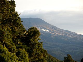
Tongariro National Park is the oldest national park in New Zealand, located in the central North Island. It has been acknowledged by UNESCO as a World Heritage Site of mixed cultural and natural values.

Lake Rotorua is the second largest lake in the North Island of New Zealand by surface area, and covers 79.8 km2. With a mean depth of only 10 metres it is considerably smaller than nearby Lake Tarawera in terms of volume of water. It is located within the Rotorua Caldera in the Bay of Plenty region.

Ngāti Tūwharetoa is an iwi descended from Ngātoro-i-rangi, the priest who navigated the Arawa canoe to New Zealand. The Tūwharetoa region extends from Te Awa o te Atua at Matatā across the central plateau of the North Island to the lands around Mount Tongariro and Lake Taupō.
New Zealand has a large number of hot springs, known as waiariki in Māori. Many of them are used for therapeutic purposes.

Mount Tauhara is a dormant lava dome volcano in New Zealand's North Island, reaching 1,088 metres (3,570 ft) above sea level. It is situated within the Taupō caldera towards the centre of the Taupō Volcanic Zone, which stretches from Whakaari / White Island in the north to Mount Ruapehu in the south. It is 6 kilometres (4 mi) east of the town of Taupō, next to the northeastern shore of Lake Taupō.

The Tongariro River is a river in the North Island of New Zealand. The part of the Waikato River from the Waihohonu Stream, down to Lake Taupo, was formally named the Tongariro River in 1945. The river originates in the Central Plateau of the North Island where it is fed by numerous tributaries that flow off the surrounding hill ranges and mountains such as Mount Ruapehu. It then winds its way north, through the township of Turangi before entering Lake Taupo via a number of river mouths. The minimum volume of water flowing down the lower Tongariro River ranges from approximately 16 cubic metres per second (570 cu ft/s) to 21 cubic metres per second (740 cu ft/s). This volume can substantially increase due to catchment of rainfall by the surrounding mountains and hill ranges.
The Hinemaiaia Stream is a river of the central North Island of New Zealand. It flows northwest from Kaimanawa Forest Park, flowing into the eastern shore of Lake Taupo at Hatepe, halfway between Taupo and Turangi. It is a popular Fly fishing stream with good numbers of Rainbow trout spawning in the winter months of June through to September.
The Tauranga Taupō River is a river of the Hawke's Bay and Waikato Regions of New Zealand's North Island. It flows northwest from its sources at the northern end of the Kaimanawa Range to reach the eastern shore of Lake Taupo close to the settlement of Rangiita, 12 kilometres (7 mi) northeast of Turangi.
The Waimarino River is a river of the Waikato Region of New Zealand's North Island. It flows northwest from its origins in the Kaimanawa Forest Park to reach the southern shore of Lake Taupo 5 kilometres (3 mi) northeast of Turangi.
The Waiotaka River is a river of the Waikato Region of New Zealand's North Island. It flows northwest from its origins in the Kaimanawa Range to reach the southern shore of Lake Taupo 5 kilometres (3 mi) northeast of Turangi.

Tokaanu is a small settlement close to Turangi at the southern end of Lake Taupo.
State Highway 41 (SH 41) is a New Zealand state highway in the central North Island that runs from Manunui, just south of Taumarunui on SH 4 to Turangi just north of the Desert Road. It comprises part of the western bypass of Lake Taupo along with SH 32.

State Highway 47 (SH 47) is a New Zealand state highway in the central North Island. It provides a link from SH 4 at National Park to SH 41 at Tokaanu just west of Turangi.

Lake Wahapo is a small glacial lake in South Westland, New Zealand, within the Westland Tai Poutini National Park and near the township of Whataroa. It was a traditional mahinga kai for local Māori. State Highway 6 skirts the lake's southern shore. The lake discharges to the Ōkārito River via a small hydroelectric power station commissioned in 1960. The ecology of the lake has altered considerably since 1967, when the Waitangitāhuna River changed course to flow into the lake.
References
- Topographic map of Turangi and its environs, nztopomap.com.