Arenalejos, Arecibo, Puerto Rico

Last updated
Arenalejos
Barrio
Carretera PR-656, Arecibo, Puerto Rico.jpg
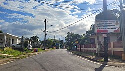
Puerto Rico Highway 656 between Domingo Ruíz and Arenalejos
Arenalejos, Arecibo, Puerto Rico locator map.png
Location of Arenalejos within the municipality of Arecibo shown in red
Caribbean location map.svg
Red pog.svg
Arenalejos
Location of Puerto Rico
Coordinates: 18°25′36″N66°40′10″W / 18.426717°N 66.669423°W / 18.426717; -66.669423 [1]
Commonwealth Flag of Puerto Rico.svg  Puerto Rico
Municipality Bandera de Arecibo, Puerto Rico.svg Arecibo
Area
[1]
  Total2.53 sq mi (6.6 km2)
  Land2.53 sq mi (6.6 km2)
  Water0.00 sq mi (0.0 km2)
Elevation
[2]
200 ft (60 m)
Population
 (2010)
  Total3,064
  Density1,211.1/sq mi (467.6/km2)
 Source: 2010 Census
Time zone UTC−4 (AST)
ZIP Code
00612

Arenalejos is a barrio in the municipality of Arecibo, Puerto Rico. Its population in 2010 was 3,064. Arenalejos is near the center of Arecibo, west of Miraflores. [3] [4] [5]

Contents

History

Arenalejos was in Spain's gazetteers [6] until Puerto Rico was ceded by Spain in the aftermath of the Spanish–American War under the terms of the Treaty of Paris of 1898 and became an unincorporated territory of the United States. In 1899, the United States Department of War conducted a census of Puerto Rico finding that the population of Arenalejos barrio was 1,228. [7]

Historical population
CensusPop.Note
1900 1,228
1910 1,38312.6%
1920 1,296−6.3%
1930 1,74334.5%
1940 1,98413.8%
1950 2,1699.3%
1960 1,946−10.3%
1970 2,1068.2%
1980 2,48518.0%
1990 2,81013.1%
2000 2,9976.7%
2010 3,0642.2%
U.S. Decennial Census
1899 (shown as 1900) [8] 1910-1930 [9]
1930-1950 [10] 1980-2000 [11] 2010 [12]

Sectors

Barrios (which are, in contemporary times, roughly comparable to minor civil divisions) [13] in turn are further subdivided into smaller local populated place areas/units called sectores (sectors in English). The types of sectores may vary, from normally sector to urbanización to reparto to barriada to residencial, among others. [14] [15] [16]

The following sectors are in Arenalejos barrio: [17] [18]

Calle Guzmán, Calle Oms, Colinas de Arenalejos, Comunidad Bithorn, Comunidad Carriones 1, Comunidad Carriones 2, Comunidad Mena, Égida Miraflores, Jardines de Palo Blanco, Sector Abra Fría, Sector Cielo Tapao, Sector Cuatro Calles, Sector Cuesta Colorá, Sector El Centro, Sector La Poza, Sector Los Pobres, Sector Miradero, Sector Palache, Sector Palo Blanco, Sector Pollera, Sector Rincón Prieto, Sector Tejada, Sector Yahueca, Urbanización Hacienda Monte Verde, Urbanización Mansiones Aztecas, Urbanización Villa Linda, and Urbanización Villa Nicole.

See also

Related Research Articles

<span class="mw-page-title-main">Espinosa, Dorado, Puerto Rico</span> Barrio of Puerto Rico

Espinosa is a barrio in the municipality of Dorado, Puerto Rico. Its population in 2010 was 4,534.

<span class="mw-page-title-main">Tanamá, Arecibo, Puerto Rico</span> Barrio of Puerto Rico

Tanamá is a barrio in the municipality of Arecibo, Puerto Rico. Its population in 2010 was 3,190.

<span class="mw-page-title-main">Arecibo barrio-pueblo</span> Historical and administrative center (seat) of Arecibo, Puerto Rico

Arecibo barrio-pueblo is a barrio and downtown area that serves as the administrative center (seat) of Arecibo, a municipality of Puerto Rico. Its population in 2010 was 8,488.

<span class="mw-page-title-main">Hato Arriba, Arecibo, Puerto Rico</span> Barrio of Puerto Rico

Hato Arriba is a barrio in the municipality of Arecibo, Puerto Rico. Its population in 2010 was 8,495.

<span class="mw-page-title-main">Miraflores, Arecibo, Puerto Rico</span> Barrio of Puerto Rico

Miraflores is a barrio in the municipality of Arecibo, Puerto Rico. Its population in 2010 was 5,863.

<span class="mw-page-title-main">Santana, Arecibo, Puerto Rico</span> Barrio of Puerto Rico

Santana is a barrio in the municipality of Arecibo, Puerto Rico. Its population in 2010 was 5,253.

<span class="mw-page-title-main">Garrochales, Arecibo, Puerto Rico</span> Barrio of Puerto Rico

Garrochales is a barrio located in the northeastern area of the municipality of Arecibo, Puerto Rico. Its population in 2010 was 2,433.

<span class="mw-page-title-main">Hato Viejo, Arecibo, Puerto Rico</span> Barrio of Puerto Rico

Hato Viejo is a barrio in the municipality of Arecibo, Puerto Rico. Its population in 2010 was 2,045.

<span class="mw-page-title-main">Arrozal, Arecibo, Puerto Rico</span> Barrio of Puerto Rico

Arrozal is a barrio in the municipality of Arecibo, Puerto Rico. Its population in 2010 was 1,445.

<span class="mw-page-title-main">Cambalache, Arecibo, Puerto Rico</span> Barrio of Puerto Rico

Cambalache is a barrio in the municipality of Arecibo, Puerto Rico. Its population in 2010 was 40.

<span class="mw-page-title-main">Domingo Ruíz, Arecibo, Puerto Rico</span> Barrio of Puerto Rico

Domingo Ruíz is a barrio in the municipality of Arecibo, Puerto Rico. Its population in 2010 was 3,153.

<span class="mw-page-title-main">Dominguito, Arecibo, Puerto Rico</span> Barrio of Puerto Rico

Dominguito is a barrio in the municipality of Arecibo, Puerto Rico. Its population in 2010 was 4,895.

<span class="mw-page-title-main">Esperanza, Arecibo, Puerto Rico</span> Barrio of Puerto Rico

Esperanza is a barrio in the municipality of Arecibo, Puerto Rico. Its population in 2010 was 1,882.

<span class="mw-page-title-main">Factor, Arecibo, Puerto Rico</span> Barrio of Puerto Rico

Factor is a barrio in the municipality of Arecibo, Puerto Rico. Its population in 2010 was 8,001.

<span class="mw-page-title-main">Hato Abajo, Arecibo, Puerto Rico</span> Barrio of Puerto Rico

Hato Abajo is a barrio in the municipality of Arecibo, Puerto Rico. Its population in 2010 was 19,699.

<span class="mw-page-title-main">Islote, Arecibo, Puerto Rico</span> Barrio of Puerto Rico

Islote is a barrio in the municipality of Arecibo, Puerto Rico. Its population in 2010 was 5,665. "Birth of a New World", a giant sculpture of Christopher Columbus on a ship, is located in Islote.

<span class="mw-page-title-main">Sabana Hoyos, Arecibo, Puerto Rico</span> Barrio of Puerto Rico

Sabana Hoyos is a barrio in the municipality of Arecibo, Puerto Rico. Its population in 2010 was 10,745.

<span class="mw-page-title-main">Guzmán Abajo</span> Barrio of Río Grande, Puerto Rico

Guzmán Abajo is a barrio in the municipality of Río Grande, Puerto Rico. Its population in 2010 was 7,367.

<span class="mw-page-title-main">Jiménez, Río Grande, Puerto Rico</span> Barrio of Puerto Rico

Jiménez is a barrio in the municipality of Río Grande, Puerto Rico. Its population in 2010 was 2,925.

<span class="mw-page-title-main">Canóvanas, Canóvanas, Puerto Rico</span> Barrio of Puerto Rico

Canóvanas is a barrio in the municipality of Canóvanas, Puerto Rico. Its population in 2010 was 22,420.

References

  1. 1 2 "US Gazetteer 2019". US Census. US Government.
  2. U.S. Geological Survey Geographic Names Information System: Arenalejos barrio
  3. Picó, Rafael; Buitrago de Santiago, Zayda; Berrios, Hector H. Nueva geografía de Puerto Rico: física, económica, y social, por Rafael Picó. Con la colaboración de Zayda Buitrago de Santiago y Héctor H. Berrios. San Juan Editorial Universitaria, Universidad de Puerto Rico,1969.
  4. Gwillim Law (20 May 2015). Administrative Subdivisions of Countries: A Comprehensive World Reference, 1900 through 1998. McFarland. p. 300. ISBN   978-1-4766-0447-3 . Retrieved 25 December 2018.
  5. Puerto Rico: 2010 Population and Housing Unit Counts.pdf (PDF). U.S. Dept. of Commerce, Economics and Statistics Administration, U.S. Census Bureau. 2010.
  6. "Anuario del comercio, de la industria, de la magistratura y de la administración. 1881". Biblioteca Nacional de España (in Spanish). p. 1614. Retrieved 4 April 2023.
  7. Joseph Prentiss Sanger; Henry Gannett; Walter Francis Willcox (1900). Informe sobre el censo de Puerto Rico, 1899, United States. War Dept. Porto Rico Census Office (in Spanish). Imprenta del gobierno. p.  160.
  8. "Report of the Census of Porto Rico 1899". War Department Office Director Census of Porto Rico. Archived from the original on July 16, 2017. Retrieved September 21, 2017.
  9. "Table 3-Population of Municipalities: 1930 1920 and 1910" (PDF). United States Census Bureau. Archived (PDF) from the original on August 17, 2017. Retrieved September 21, 2017.
  10. "Table 4-Area and Population of Municipalities Urban and Rural: 1930 to 1950" (PDF). United States Census Bureau. Archived (PDF) from the original on August 30, 2015. Retrieved September 21, 2014.
  11. "Table 2 Population and Housing Units: 1960 to 2000" (PDF). United States Census Bureau. Archived (PDF) from the original on July 24, 2017. Retrieved September 21, 2017.
  12. Puerto Rico: 2010 Population and Housing Unit Counts.pdf (PDF). U.S. Dept. of Commerce Economics and Statistics Administration U.S. Census Bureau. 2010. Archived (PDF) from the original on 2017-02-20. Retrieved 2019-08-02.
  13. "US Census Barrio-Pueblo definition". factfinder.com. US Census. Archived from the original on 13 May 2017. Retrieved 5 January 2019.
  14. "Agencia: Oficina del Coordinador General para el Financiamiento Socioeconómico y la Autogestión (Proposed 2016 Budget)". Puerto Rico Budgets (in Spanish). Retrieved 28 June 2019.
  15. Rivera Quintero, Marcia (2014), El vuelo de la esperanza: Proyecto de las Comunidades Especiales Puerto Rico, 1997-2004 (first ed.), San Juan, Puerto Rico Fundación Sila M. Calderón, ISBN   978-0-9820806-1-0
  16. "Leyes del 2001". Lex Juris Puerto Rico (in Spanish). Retrieved 24 June 2020.
  17. "PRECINTO ELECTORAL ARECIBO 026" (PDF). Comisión Estatal de Elecciones (in Spanish). PR Government. 19 October 2018. Retrieved 2 August 2020.
  18. "PRECINTO ELECTORAL ARECIBO 027" (PDF). Comisión Estatal de Elecciones (in Spanish). PR Government. 8 October 2019. Retrieved 2 August 2020.